Today will feature clearing skies with a chance for a shower in the morning. Temperatures will be still above average topping out near 60.
Monthly Archives: November 2011
Todays weather 11-29-11
Today will feature cloudy skies across the region with the chance of an isolated shower. Temperatures will top out in the mid 50s.
Stay tuned!
-Jack
Outlook for 11.28.11-12.2.11
An active but mild pattern as we head through the middle of the workweek with showers late Tuesday and a steady, heavier rain Wednesday. Thursday and Friday will be sunny with more seasonable temperatures to kick off December.
Stay tuned!
-Jack
Weekend outlook
As we head into this weekend saturday will be the better of the two days with sunny skies and a mild 53 degrees for a high. Sunday will showcase more clouds and the chance for an afternoon shower. Temperatures will peak out around 50 degrees sunday.
Storm snow totals
Some impressive totals for this late-november snowstorm.
Fryeburg…………………….15.0″
Bartlett……………………….13.0″
Jackson………………………13.0″
Chatham……………………..12.7″
Harrison……………………..12.0″
Glenn………………………….11.5″
Sunday River……………….12.0″
Augusta………………………10.5″
Auburn………………………. 10.0″
Randolf……………………….10.8″
N. Sebago……………………10.1″
Lisbon Falls…………………10.0
Casco………………………….10.0″
Hope……………………………10.0″
Otisfield……………………….10.5″
Richmond……………………..10.0″
Bethel…………………………..10.0″
Jefferson………………………10.0″
Paris……………………………..10.0″
New Gloucester……………..9.6″
Windham……………………….9.0″
Lewiston………………………..9.0″
Jay………………………………..9.0″
Farmington…………………….8.0″
Turner……………………………8.0″
Jefferson………………………8.0″
Cornish…………………………7.8″
Brunswick……………………..7.5″
Hollis…………………………….7.4″
Yarmouth…………………………7.1″
Cumberland……………………7.0″
Camden………………………….5.0″
Buxton……………………………5.0″
Rangeley………………………..5.0″
Westport Island………………1.5″
Westbrook……………………..1.0″
Portland (Deering)…………..1.0″
SKI RESORT SNOW TOTALS
Attitash…………………………14.0″
Wildcat………………………….11.0″
Sunday River………………….11.0″
Bretton Woods………………8″ to 10″
Cranmore……………………..11.0″
Great Glen Trails……………9.0″
Jackson XC……………………8.0″
Sugarloaf……………………….8.0″
King Pine ………………………8.0″
Loon………………………………8.0″
No more snow in the forecast 😦 a gradual warmup is expected this weekend with a few showers late sunday.
Stay tuned!
-Jack
Storm update #16
At 9:00 am EST the snow is still holding strong here in Yarmouth and with falling temperatures I expect it to stay that way. Already there is 5″on the ground here and with more to come I am a little suspicious that the totals might top 10″ here in Yarmouth and anywhere west of here. In the foothills I expect 12-14″.
Stay tuned!
-Jack
Storm update #15
I have journeyed outside for the first time this morning and the snow is accumulating fast. I now expect something like 5-9″ here along the mainland coast with pure rain along the coast south of Portland. I will continue to monitor the forecast as the complex patterns above our heads keep arguing over weather it should be a rain storm or a snow storm.
Stay tuned!
-Jack
Storm update #14
Sadly the warm air has won and we should not expect very significant accumulations if any.
Stay tuned!
-Jack
Storm update #13
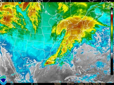
As we get the last update for tonight I have seen that the storm has relocated its center to over lake ontario moving ESE into NY and PA. All other forecasts remain the same. As of 9:30 a few showers have crossed the border into ME.
Stay tuned, I will be back in the morning with more info.
-Jack

