Happy weekend everyone!
Cool and clear conditions are expected today with highs in the 40’s to low 50’s under sunny skies.
-Jack

Happy weekend everyone!
Cool and clear conditions are expected today with highs in the 40’s to low 50’s under sunny skies.
-Jack
Hello everyone!
Today will feature mainly sunny skies with a return to cooler temps as high pressure moves closer to the region. Expect highs in the 40’s to lower 50’s with breezy WNW winds making an appearance as well. Gusts to 20mph are possible.
-Jack
Hello everyone!
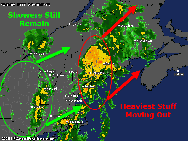
Our long-awaited storm is here and heavy rain is falling across the area with the expected strong winds as accompaniment. The heaviest of rain is north and east of Portland as of 5:15 this morning and this area of intense rain/wind will continue to move NE in the coming hours. Behind that lies a batch of very heavy rain over SE MA and lighter showers over eastern NY. The SE MA rain is moving NE and will likely impact the midcoast with another round of torrential rain and gusty winds. More showers lurk back in NY associated with cold front #1 today and expect one last shot at intense rain and driving winds as this moves through.

Behind those showers, which arrive 9-10 AM, expect clearing skies and warming temps. By mid/late afternoon, temps in the 70’s are likely under partly sunny skies. Another cold front moves through this evening which touches off some showers and possibly a few thunderstorms too. For a minute, it just may feel more like August than October. Temps drop a bit behind the front but a continued stretch of very mild weather looks to be on the way for the next week or so.
-Jack
Hello everyone!
Our upcoming rain and wind event remains largely on track and only minor adjustments are needed to the forecast this evening.

Rain is starting over western and northern areas but most of the steady heavy stuff lurks back over NY and points south. Rain will continue to overspread the area this evening and will become heavier as the night goes on. Winds will also increase gusting over 50 mph at the coast where a wind advisory is up. Lesser winds are expected inland but some gusty conditions are still likely. Total rainfall totals remain the same with 1-1.5″ likely for most with higher amounts to 2-2.5″ on the south facing slopes of the mountains.
Rain winds down tomorrow morning along with winds but temps will be on the rise getting up into the 70’s! Cooler weather is likely for the end of the week.
-Jack
Hello everyone!
Today will feature the arrival of our storm system that I have talked about for a few days now. We start off nice and chilly this morning with some breaks of sun before clouds finish overspreading the area later this morning.

Winds increase along with clouds today out of the east shifting south-east and becoming quite strong by evening. Rain will approach the region arriving in western areas around 3-4 PM and eastern areas closer to 6 PM. The worst conditions will arrive around midnight tonight with heavy rain and high winds peaking through 7 AM or so. Wind gusts to 60mph are totally in play for coastal areas, the farther east you go up the coast the more likely you are to see that type of wind. Winds will be lesser inland but will quickly increase again with elevation especially above 1-2 thousand feet. A general 1-1.5″ of rain is likely with more in the favored SE upslope areas.
I’ll have another update as the storm starts up this evening.
-Jack
Hello everyone!
Not too much has changed since yesterday in terms of our upcoming heavy rain event. Here’s a quick updated rundown of what to expect.
Rain

Rain moves in during the evening hours tomorrow arriving in SW areas around 5 or 6 tomorrow evening with most of the area seeing rain by 7 or 8 PM. The heavier rain will hold off until later in the evening beginning in the west around 9 and spreading east through midnight. Between midnight and 6 AM or so, expect the worst conditions to occur with heavy rain being driven by strong winds.

While available moisture (Precipitable Water, shown above) is quite high, as well as forcing for wringing out that moisture, the ideal parameters are only really in place for about 6 hours early Thursday morning. As a result, total rainfall will be limited somewhat compared to if this was a more slowly moving system. A total of 1-1.5″ of rain is likely with 2-2.5″ amounts on south-facing mountain slopes.
Wind

Winds will become gusty tomorrow afternoon out of the SE as the front approaches. Expect winds building throughout the day with peak gusts arriving in the same 6 hour window as the heaviest rain from 12-6 AM Thursday. Most areas should see 15-25 mph winds with gusts to 35mph while the coast sees 25-35 mph winds gusting to near 60 mph. The plot above shows winds (everything but the yellow line, in knots) and the mixing layer (yellow line). Any winds below the yellow line are eligible to mix down to the surface in heavy precip. In heavy precip early Thursday morning, someone along the coast is likely to see some of those intense winds aloft mixed down on the order of 50-60 mph. The greatest threat for this is the NE coast closer to Penobscot Bay where a wind Advisory is up. All coastal areas should be prepared for strong winds, the chart above is for Portland.
Takeaway
Rain begins tomorrow evening becoming heavy late at night. Winds will also be on the increase out of the SE. Peak rain and wind occurs 12-6 AM Thursday with wind gusts approaching 60 mph along the coast. A total of 1-1.5″ of rain is likely with more on the south-facing mountain slopes where 2-2.5″ is likely.
I’ll have more updates tomorrow in a similar patter to today’s updates.
-Jack
Hello everyone!
Today will feature mainly sunny skies and nice temps as high pressure remains locked in over the region. Lows this morning are a bit chilly but will warm nicely to a few degrees on either side of 50 maybe with some cooler temps up north.
Rain moves in tomorrow, I’ll have another update on that this evening.
-Jack
Hello everyone!
Our midweek heavy rain event is still very much on track for Wednesday afternoon through Thursday morning. Tonight’s update will focus more on specific impacts rather than larger scale setups.
Rain
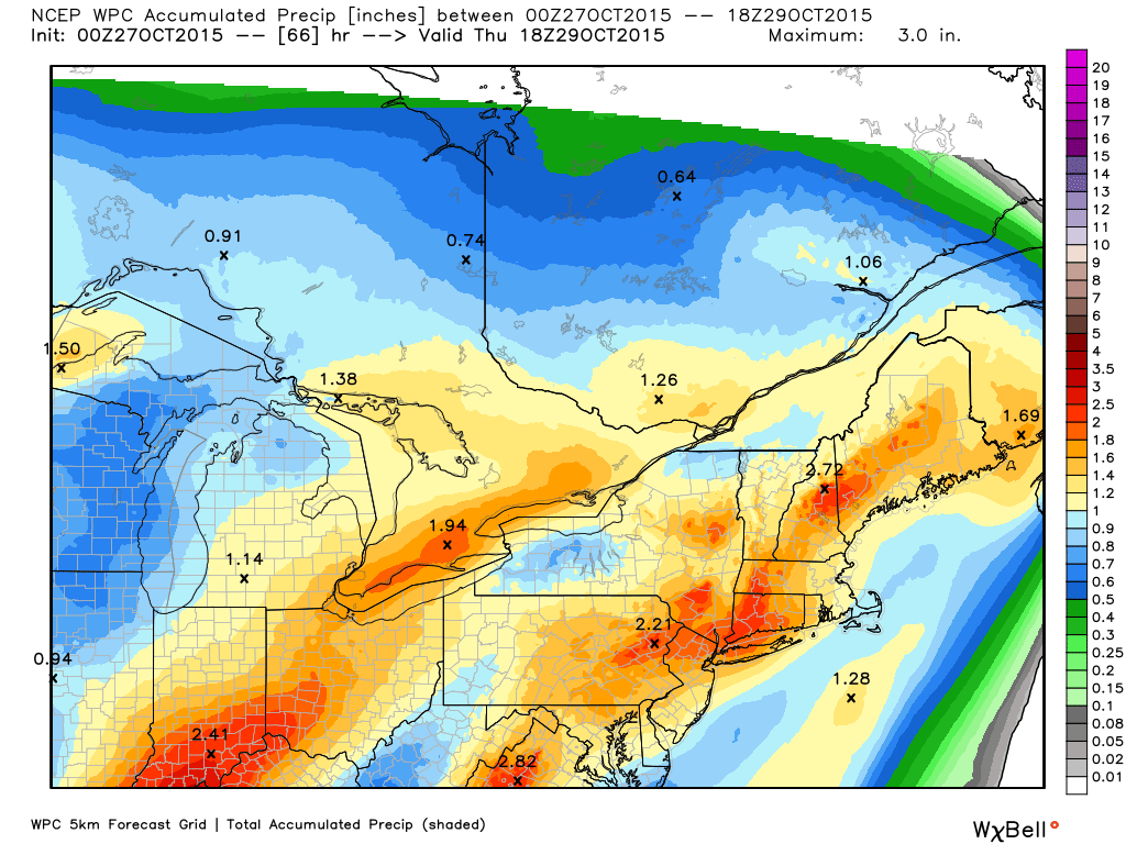
Heavy rainfall is likely to be the main threat from this storm as Patricia’s moisture streams northward and interacts with the approaching cold front. A general 1-2″ is likely (Tan-Orange shadings on the map) with some 2-3″ amounts likely in the favored upslope areas (reddish shadings on the map). The fast moving nature of this system is what will keep precip amounts relatively low and given the quick arrival of dry air from the west Thursday morning, heavy precip should be centered in the 8PM-6AM timeframe which will limit total rainfall. Rain is likely to arrive earlier in the evening Wednesday likely closer to 5 or 6PM. These details will continue to be refined in the coming days.
Wind

With a strong cold front comes strong winds and this time is no different. A SE gradient will sharpen up during the day Wednesday leading to very strong winds by Wednesday afternoon into the evening. On the map above, the yellow line is the mixing layer and the red/green/blue contours are wind speeds. Elevation is the y-axis and time is the x-axis but read from right to left (I didn’t make the graph I promise! (credit to that goes to BUFKIT)). The takeaway is that any wind under the mixing layer is ‘eligible for a ride to the surface in heavy rain. Given the likely heavy rain early Thursday morning which coincides with the strongest winds just above the surface, very high winds are definitely a concern from midnight Thursday to 6-7AM or so. Expect the highest winds along the coast 20-30 mph with gusts to 55 mph or so. Lesser winds are expected elsewhere. With this kind of wind, saturated ground from the heavy rain, and some leaves definitely still on the trees, scattered power outages are likely especially along the coast.
The tides don’t look to line up particularly well for coastal flooding but some minor splashover is possible in the usually suspect areas.
I’ll follow today’s update pattern again tomorrow with daily weather in the morning and then a storm update in the evening.
-Jack
Hello everyone!
Today will feature chilly conditions but otherwise quiet weather as high pressure builds in from the north. Look for highs in the 40’s north and low 50’s south under mainly sunny skies. Winds won’t be brutally strong but they’ll be noticeable at 5-15 mph from the NW.
For those who may have missed it, check out last night’s blog post for details on the upcoming rain event Wednesday into Thursday.
-Jack
Hello everyone!
Special evening update tonight to discuss an upcoming heavy rain/strong wind event slated for the afternoon hours Wednesday into the morning Thursday. If you want to skip the explainers, scroll to the bottom where I have a summary of the impacts and timing of the storm. Lets dig right in.
Setup
By looking at the satellite imagery this evening, you can see all the players on the field so to speak most notably ex-Patricia in the Gulf of Mexico and a Pacific storm near the Washington coast.

Ex Patricia will move east and meander through the Gulf States causing flooding issues for LA and MS in the next few days. From there, the system and all its moisture moves NE. The Pacific storm moves over the Rockies and redevelops in the Canadian Plains. They look to combine over the Great Lakes developing into a powerful low by Wednesday.
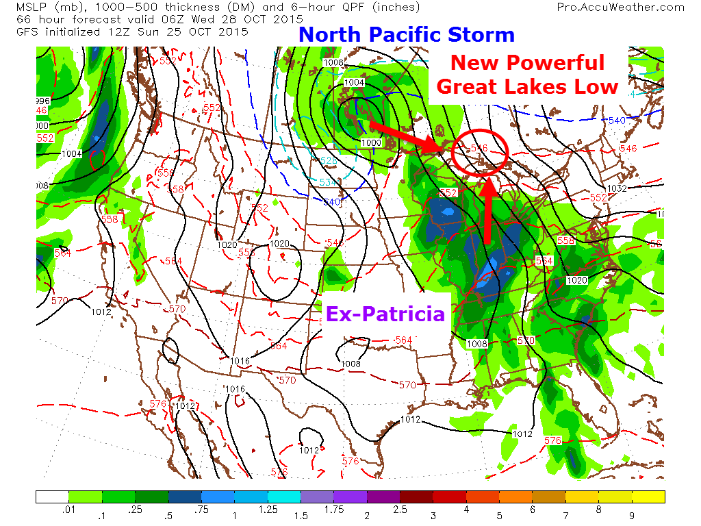
By Wednesday the two will have combined into a strong low over the Great Lakes and a strong cold front will be heading our way. Tying together Patricia’s moisture and the energy from the northern Pacific storm.
Impacts
Rain

With one of the main players being Ex-Patricia in this storm, there will be a lot of available moisture. The map above is Precipitable Water for late Wednesday night showing tropical moisture streaming northward ahead of the front signaling the atmosphere is ripe for heavy rain. Consider the sponge saturated. Now all we need is something to wring it out.

If you’ve followed the blog for a while, you’ll know vertical velocity is one of my favorite maps to show during heavy precip events. For those who may be unfamiliar with this map, it can be boiled down to how fast air is rising. The faster air rises, the faster it cools/condenses and thus the faster the moisture can be turned into rain. Basically: the more vertical velocity (upward motion), the heavier the precip. This force is what wrings out the sponge that the moisture from Ex-Patricia brought. The above image shows intense upward motion along the coastal plain Wednesday evening that will spread NE through the night indicating a thorough soaking for all. In terms of final amounts, a general 1.5-2.5″ is likely with some localized amounts of 3″+ generally on the south facing slopes of the Whites where upsloping will be strongest.
Wind

With intense low pressure rapidly intensifying to our west, it’s no surprise winds look to be an issue with this storm. Shown to the right is the GFS Low Level Jet parameter which gives an indication of what the winds are a few thousand feet above the surface. Given the proper conditions, some part of these winds can be ‘mixed’ down to the surface in heavy rain bands. The downdrafts associated with these heavy rain bands acts kind of like a mirror deflecting some of the winds aloft towards the surface. Not all of the winds make it down. While this model indicates near hurricane force winds aloft, winds at the surface are unlikely to be that strong. Expect winds at the surface to range from 20-35mph with gusts approaching 50mph. That’s still high enough to cause some issues with scattered power outages and tree branch casualties. Winds will be out of the south/southeast for Wednesday and early Thursday before turning NW later in the day Thursday.
Coastal Flooding

With strong SE winds for a decent amount of time and for an exceptionally long distance over the Atlantic combined with astronomical high tides this week will create the risk for some coastal flooding. This is by no means a textbook coastal flooding event and only minor impacts are expected for most but some beach erosion and minor splashover are likely. The two high tides to watch will be Wednesday midday and Wednesday night but due to the slow evolution of the SE winds Wednesday, there is unlikely to be a prolonged period of strong winds and thus coastal flooding looks to remain a relatively small threat.
Summary
Rain will move into the area Wednesday afternoon continuing through Wednesday night and extending into Thursday morning. Rain will be heavy at times Wednesday night adding up to 1.5-2.5″ for most with some 3″+ totals on the south facing slopes of the mountains. Winds will also be gusty with 20-35 mph winds out of the south/southeast gusting near 50mph Wednesday night.
I’ll be back tomorrow morning with more on tomorrow’s weather and I’ll have another update on this rain event tomorrow evening.
-Jack
