
Great day on tap today! A few high clouds are possible at the coast this afternoon but other than that and a little bit of morning fog, it looks to be a beautiful fall day.
-Jack

Great day on tap today! A few high clouds are possible at the coast this afternoon but other than that and a little bit of morning fog, it looks to be a beautiful fall day.
-Jack
This upcoming week will be a great week in terms of weather. We have sunny skies, mild temps and a storm-free forecast.


Overnight we received the new model run that starts off each day. In this model run, all the models shifted eastward and formed a tighter consensus on track/intensity.


The 12z model run shows great disagreement between models as the ocean storm slated to hit Monday approaches. I’ll start by going over some of the things that are very clear.
-This will not be a significant storm. There is agreement that there will be nothing more than rainy and breezy conditions at the very worst with a much more likely scenario being that the immediate coast gets affected with a band of light rain and breezy conditions.
-Timing. There is solid agreement that the rain, if any, will impact the region late Monday into early Tuesday. Not much disagreement on that front.
However, the models still have no nail down 2 key aspects of the forecast.
-Track. The general consensus it that the storm will come up the coast and move to the SE of the 40N 70W benchmark and then move north or north-northwest towards the Canadian Maritimes.
-Intensity. The strength of the low is also very important. The NAM model has a 990mb low where the GFS has a 1008mb low. This ranges from pretty strong to pretty weak.
What my forecast calls for. I think a storm of weak intensity will track just SE of the benchmark. It will then move N towards the Maritimes. I think that the only impacts will be a band of light rain affecting the coast and light winds also limited to the coast.

-Jack
Last night, models made no progress in agreeing with one another though one little, important feature was hinted at by nearly all of them. This little feature is a band of rain that is driven off the NW periphery of the low and forms almost its own micro-entity. This is a self sustaining band of precipitation displaced well over 500 miles from the center of the storm and feeds off the energy in the water-like a tropical storm. Another characteristic of tropical cyclones they share is that when they hit land, they dissipate. Unlike tropical cyclones however, they do not have any winds associated with them (any wind is from the low out in the ocean) and they are short-lived like a band of thunderstorms passing through on a summer day. Anyway, the NAM model is by far the most aggressive in terms of both the low development and the band of showers. The GFS brings the band in very weak and puts the low closer to shore but weaker. The euro brings the low farther out than the GFS but stronger and dissipates the band of showers before it reaches the coast. I am going with a GFS/euro hybrid by taking the euro’s idea of a stronger low a little farther offshore and combining it with the GFS’s idea that the band of showers makes it to the coast.

Another example of the volatility in weather forecasting will unfold early next week. Yesterday, there was good agreement that the ocean storm that we had been monitoring was going to go out to sea. Now the models ore more divided with the Euro taking it farther to the east while the GFS brings it closer to the coast. I chose a track more on the Euro side of things but I brought in a light band of rain as the CMC suggests. The CMC track is closest to where I think it will track. The GFS brings in a band of heavy rain and puts the low in the Gulf of Maine. I do not thinks this is the right idea as the upper level trough thought to help turn the storm to the west likely will not be as strong as the GFS predicts. However, the GFS has been more or less consistent form run to run on this system so that scenario cannot be discounted.
IPCC climate report- The Intergovernmental Panel on Climate Change (IPCC) which is a group of top scientists and policymakers that convene every 5-6 years and produce a 3,000+ page report on climate change. They do this over a period of about a year and the first part of the 2013-2014 report came out early this morning. One key fact it pointed out is that there is a 95% chance humans are causing climate change. Dr. Jeff Masters has a great post summarizing this stage of the report. I encourage everyone, particularly those skeptical of climate change, to look at this article. It’s very informative and sheds light on some of the potential impacts that our energy consumption has on the planet and on civilization.
-Jack
The first disappointment (or victory) of nor’easter season has come. The storm slated to come up the East Coast looks to be heading out to sea. All the models are on board with that solution or one like it so that is what the forecast calls for with reasonably high confidence. Expect a beautiful weekend with temps in the 70’s region-wide. Sunny over the weekend with a few clouds Monday. Storm free for the next 7 days it looks like.
-Jack
The end of this week will be more of the same across New England. Cool days and cold nights are on tap with sunny skies dominating region-wide. All eyes shift to next week for the potential of an oceanic storm.
Thursday: Sunny and cool. Less windy with temps in the 60’s for highs and the 40’s for lows.
Friday: More of the same. Great way to end the week-sunny and cool.
Saturday: Milder with highs near 70 across Maine and mid 70’s across the rest of New England Sunny.
Sunday: 70’s With late day clouds on the increase.
Monday: Big storm? Or sunny? Uncertainties abound here but I will continue to watch the potential for a powerful ocean storm.
I will have more on the storm potential if it looks more likely…
-Jack
Since my last post, TD 7 intensified into TS Gabrielle and then the LLC got separated from the MLC and has since weakened into a TD. I expect it to dissipate tonight. In other weather news, invest 99L in the Bay of Campeche is slowly organizing however I doubt there will be much in the way of development because the system will hit Mexico in the morning. A tropical wave in the Central Atlantic, the remnants of 98L has been highlighted in the NHC’s tropical weather outlook as a potential threat to develop.
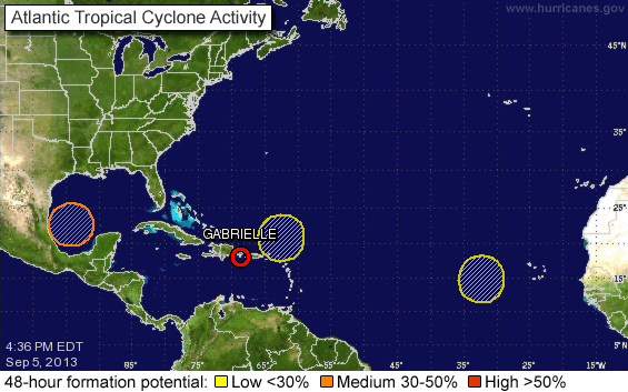
This is the NHC’s tropical weather outlook. The yellow circle to the NE of Gabrielle is a strong tropical wave that has been sucking the energy from Gabrielle.
I’ll have another quick update tomorrow with a much more detailed post over the weekend.
-Jack
97L has improved everything substantially in the past hour or 2 and has earned the distinguished title of Tropical depression 7. I will outline the forecast below.

This shows TD 7. Notice the clear spiral bands, the convection near the center, and a more symmetrical shape. Also notice the good outflow on all sides.

The NHC track projection for TD 7 (07L). I expect this to be highly accurate however, there is another scenario drawn up by a credible model: the GFS. This model has the storm moving NNW then stalling and moving due W. This is possible and here’s why. The factor that might allow for a track to the NNE/N/NNW is a break in the ridge of high pressure that steers any storms to the west. When there is a weakness in this ridge, storms are sucked into it like a vacuum. This is what the NHC is calling for. However, some models forecast that this gap will close before the storm sneaks through. Like a gate closing in a spy movie while the spy rolls under at the last second. So we’ll just have to wait and see. I have little confidence it will impact the US with more than a solid swell.
Land areas that could be affected: Puerto Rico, Hispaniola (Dominican Republic, Haiti), Bermuda, Maritime Canada. This list will be updated as the track projection changes. This is just my idea of where the storm will go and who it might affect. For decision making refer to the NHC.
My next update on the storm will be around the same time tomorrow.
-Jack
