Warm air on the way

Hello everyone!

Today will feature the return of reasonable temp with highs in the 30’s across the state. In addition to that, there will be few clouds in the sky so today should be pretty good weather wise. Our next chance for precip should arrive Sunday with some rain. Our next chance for snow could arrive Wednesday.

-Jack

Arctic air retreats

Hello everyone!

Our weather for the next few days holds promise for those who dislike the cold as the extreme cold moves north and east. Temps will not deserve ‘warm’ but they sure will feel comfy after last week. Despite current temps in the 10’s, we make it above 20 today under sunny skies so no complaining here. Our next chance for light snow/mixed precip arrives this weekend.

-Jack

Cold returns

Hello everyone!

Today will feature the beginning of a brief arctic outbreak that will last until Friday. Highs will be in the 10’s and lows will be in the single digits. Partly cloudy skies will dominate both today and the rest of the week with a few more clouds on Friday in advance of our next weather maker. I see no big storms in sight as of now.

-Jack

Light rain/freezing rain/sleet/snow today

Hello everyone!

Sorry for the late update again! Still not feeling great and woke up about 10 minutes ago. Today will be one f those ‘all of the above’ days in terms of precip. A very strong arctic front will move through with rain, freezing rain, sleet, and snow and location will determine your precipitation type this morning but as the front passes through, everyone changes to snow with light accumulations possible. Temps will be in the upper 20’s and lower 30’s for most this morning with gusty S winds. As the front moves through over the course of the afternoon, everyone drops into the 20’s and changes over to snow. I see no big storms in sight  we return to seasonable or just below average temps this week.

-Jack

Bitter cold continues

Hello everyone!

Sorry about the lateness of the update this morning. Forced to take a day off from school because I’m not feeling too great so I slept in. In any case, the bitter cold that has been affecting the region for the past few days will continue today with temps in the 0’s 0r 10’s above/below 0 depending on location. However, for those who dislike the cold, there is relief in sight. A warm front will bring temps into the upper 20’s/lower 30’s on Saturday however, at least in the state of Maine, breaking the freezing mark is unlikely. As with any large temperature shift, precipitation in the form of snow will accompany this ‘warmth’. Amounts should be light in the 1-3″ range. A strong arctic front will reintroduce light snow Sunday into Monday. Temps will be a tad more seasonable next week with highs in the lower 20’s and lows near 0.

-Jack

Bitter cold today

Today and tomorrow will feature extremely cold air and light winds as well. Highs will top out around 10 inland and around 15 at the coast. Winds will only be blowing at 10-15 mph however that is just enough for wind chills to fall below -20 at the coast and -40 inland. Bundle up!! The cold stays put until Saturday when strong southerly winds bring in comparatively mild air. Temps on Saturday could flirt with 30 degrees. Along with the warmth comes some light snow which shouldn’t accumulate too much however slick travel is possible. Temps plunge back down to current levels for next week.

-Jack

Cold air says locked in place through the weekend

Hello everyone!

Oops! The storm just stayed too far offshore so as a result, we got nothing. Oh well! this storm will have at least one effect on our weather though, winds will change direction as it moves offshore and NW winds will bring in some cooler air. It will be pretty chilly this week with highs in the 10’s and lows in the -10’s. Cold air will stay until the weekend when SW winds bring in warmer air. However, it is highly unlikely we get above freezing. I see no big storms in the forecast for this week or next.

-Jack

Snow today into tomorrow, cooler air moves in mid week

Hello everyone!

Today will feature mostly cloudy skies with snow moving in later in the afternoon. Snow should arrive in Boston between 1 and 2 this afternoon with areas north of there likely waiting until after dark to get any flakes. Temps today will be cool but not cold with highs in the 10’s and 20’s. By this time next week, 20 will feel like a sauna as even colder air moves in.

Snow map 1-21 v1


Above is my thought as to snowfall accumulation for New England. Southern areas see more as they are closer to the storm.

the rest of this week is quiet and cold before more light snow next weekend. Bitter cold temps invade next week.

-Jack

Snow returns tomorrow into Wednesday

Hello everyone!

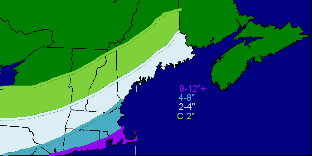
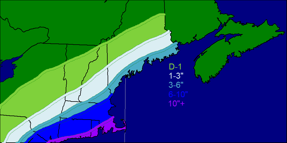
After a mild couple weeks, we are back to winter for at least the next few weeks as a persistent trough keeps arctic air in place and allows for periodic snow chances. Our first chance for snow will be tomorrow into Wednesday as a deepening low offshore spreads light to moderate snow over southern and coastal areas. Amounts will generally be in the 1-3″ range with 3-6″ along the coast. The mountains will be farther away from the storm thus a general dusting to 1 or 2″ is expected. Heavy snow can be expected along the coast of CT as well as RI and SE MA. Amounts there could approach a foot.

Snow map 1-20v1


Snowfall map for tomorrow into Wednesday. Highest amounts are confined to Southern New England.

Winds will play a role in this storm as well with gusts approaching 25-30 mph along the coast. Down along the Cape, blizzard watches have been issued as winds will approach 40 mph blowing the snow around significantly.

Due to the cold air in place, this will be a dry, powdery snow that can blow around easily. Reduced visibility will be an issue overnight Tuesday into Wednesday morning. Despite this, I expect but minor travel/school impacts here in Northern New England unless it tracks farther NW which is certainly a possibility.

Cold air invades this week with highs in the 0’s or 10’s and lows well below 0. Our next snow chance will arrive for the weekend possible into early next week. Even colder air will invade next week.

-Jack

Snow today, Arctic outbreak next week

Hello everyone!

As we start out the long weekend, snow will lead headlines as an intensifying ocean storm passes out to sea producing a norlun trough. These troughs are notorious for being nearly impossible to predict as they are highly localized. Precip is slowly creeping up the coast this morning and should reach Portland mid-morning or so.

Snow map 1-18 v1


Even areas highlighted in green will likely see at least a few flakes however, accumulations of more than an inch are highly unlikely. I will almost certainly update this as the storm develops and I will post the new map this afternoon on twitter @jacksillin . I expect the 3-6″+ zone to be shifted around and maybe expanded a tad though confidence is just too low to do that now. This storm will be a ‘nowcasting’ event where forecasts are made, and changed based on observations during the storm rather than models way out ahead of the storm.

Temps will be very marginal today running in the low to mid 30’s. As a result this will be a very wet, heavy snow that could cause a few widely isolated power outages though that will likely not be much of a problem.

An arctic cold front will cross the region Sunday night bringing in more icy cold air and the chance for a snow shower or squall.

Our next chance for snow could arrive late week. Stay tuned!

-Jack