Cloudy but Mostly Dry Today

Hello everyone!

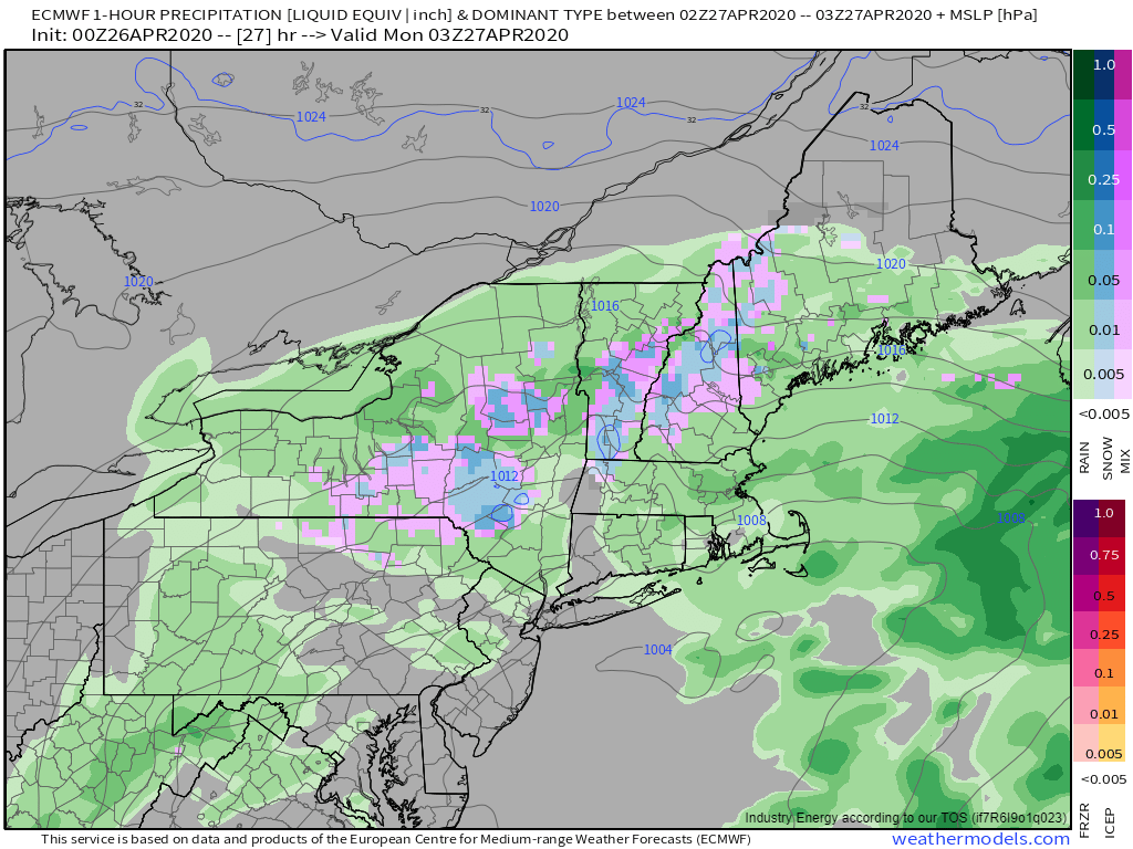
Today will feature mostly cloudy skies and generally dry conditions as our next storm gathers steam to our west. The core of this storm will arrive tomorrow in the form of a long/narrow band of heavy rain. Interestingly, this band has already formed and is currently moving through Pennsylvania. Why won’t it get here until tomorrow if it’s so close this morning? The band is oriented north-south and throughout the atmosphere in the vicinity of the band, winds are nearly due southerly. Because the band is pushed east by whatever component of the wind is oriented perpendicular to the band, its forward motion is quite slow.

All that to say that the storm will be on our doorstep today, but we won’t see much in the way of heavy precipitation until tomorrow. One exception to the ‘generally dry’ rule will be across NH this morning. A batch of rain is moving north from CT/MA towards the NH border and should arrive in the next hour or so across SW NH. Most high-resolution model guidance indicates that this batch of rain will fall apart as it continues moving north, but as far as I can tell, the mid-level moisture pocket associated with this batch of precip is a bit more robust than guidance suggests. With that in mind, don’t be shocked if northern parts of NH and western parts of ME end up with a few drops at some point later this morning. The best chance for steady rain will be found along the SE-facing slopes of the mountains.

Temps today will fall back into the low to mid 40s for most of the area. A few 50 degree readings are possible in southern NH and northeast of Waterville.

-Jack

Sunshine Finally Returns Today

Hello everyone!

Sunshine will finally return to the region today as high pressure slides in from Canada between our finally-departed coastal storm and our next system which is organizing over the Great Lakes. Mostly sunny skies are noted across the area on satellite imagery and with a glance out the window this morning. Mid/high clouds are slowly beginning to spill over the top of the ridge ahead of the storm out in the Great Lakes. We’ll start to see those clouds arrive in our region during the midday/early afternoon hours. High temps today will actually make a run at seasonal norms and will range from the upper 40s along the coast to mid/upper 50s for most of the interior to low 60s in southern NH.

Enjoy the sun while it lasts today, there’s a good chance we won’t see it again until Sunday.

-Jack

Slowly Improving Weather Today

Hello everyone!

Today will feature slowly improving weather as the area of low pressure responsible for bringing rain and snow to the region over the past couple days moves slowly east. A few lingering bands of showers/flurries are noted on radar and with a glance out the window this morning. These shouldn’t result in any accumulations and will dissipate within the next couple hours. Cloud cover will take a bit longer to move out of the area, but by sunset western parts of the region may be able to catch a glimpse of the sun. High temps will remain well on the cooler side of normal, ranging from 45 in the mountains to around 50 or perhaps 55 in interior parts of Maine and SW NH.

-Jack

Cold and Wet Today

Hello everyone!

The storm we saw move in with rain and snow last night will lose its forward momentum near Cape Cod today. As a result, we’ll be stuck with chilly temps, a noticeable north/northeast breeze, and bands of rain/snow. Current observations suggest that rain is the dominant precipitation type through the I-95 corridor while snow is falling up in the mountains and in some parts of the foothills. The tug of war between the warming influence of the late April sun and the cooling influence of heavier precipitation bands will determine who exactly gets rain and who gets snow today. Of course the mountains have the best shot at seeing enough snow to pick up a few more inches of accumulation. The foothills will likely see snow fall for much of the day, but it will struggle to accumulate outside of grassy/elevated surfaces. The coastal plain will see mostly rain but some flakes could mix in from time to time as the heavier bands rotate through. No accumulation is expected along the coast except for perhaps a transient coating on the coldest available surfaces.

High temps today will be outrageously cold for April 27th, ranging from 40 along the NH Seacoast to 32 in the mountains. Most of us will see temps top out in the mid to upper 30s. That’s about 20-25 degrees below normal, and may be good enough to set some low maximum temperature records at the various climate sites.

Either way, today is the perfect day to get the wood stove going and camp out by the fire. More dreary weather is expected tomorrow, though precipitation looks to be a bit more showery in nature.

-Jack

Another Late-Season Winter Storm Approaches Today

Hello everyone!

While May is now just a few days away, the atmosphere appears to be joining many of us in reminiscing about more “normal” days earlier this winter. With that in mind, we’ll be doing our best ‘early March’ impression over the next few days as a coastal storm develops and redevelops several times over the Mid Atlantic and the waters off Cape Cod.

The first round of redevelopment is now underway off the Delmarva. As that low moves in our direction, expect any morning breaks of sun to quickly fade behind a thickening overcast over the next hour or two. Precipitation is already knocking on SW NH’s doorstep according to radar imagery but so far none of it appears to be making it to the ground. Rain will begin in SW NH around 1-2 PM before advancing northeast into Maine around 3-4 PM. Before the storm arrives, temps will jump into the mid 40s in SW NH, upper 40s in the mountains and along the coast, and low to mid 50s for interior parts of Maine. Initially, as precipitation moves in during peak heating hours, the precipitation type will be rain. However, as we approach sundown, a change to snow will begin in the higher elevations of NH and western ME.

This model forecast snapshot valid at 11 PM today shows snow falling in the mountains with a mix in the foothills and rain along the coast. Temperatures aloft are supportive of snow all the way to the coast (except perhaps for the Midcoast peninsulas) so precipitation type will be determined entirely by surface temperatures (generally lingering in the mid 30s). With that in mind, expect precipitation type to be determined largely by precipitation rate. When heavier bands arrive, snow will fall all the way to the coast. During lulls, much of the coastal plain will flip back to rain while light snow continues in the foothills and mountains.

This pattern will generally hold through tomorrow as the storm reaches its peak (though still quite modest) intensity just east of Chatham MA. We’ll be in the perfect spot for heavy bands just NW of the low which means that snow is likely to advance closer to the coast. On the other hand, the strong late-April sun will be working to warm temps near the surface. Even if temps rise by just a few degrees, that would be enough to knock precip types from snow to rain. Either way, snow will have a hard time accumulating during the daytime hours tomorrow. We’ll have a better sense of what the storm will do tomorrow once we see the whites of its eyes.

Believe it or not, this system will continue to bring rain and snow to the area on Tuesday as it slowly meanders east.

-Jack

Warmer and Sunnier Today

Hello everyone!

It may be overcast across much of the area at the moment, but clearer skies are on the way as dry air floats into the region from Canada. Look for skies to clear from NW to SE over the next few hours which will leave us mostly sunny by midday. The strong April sun will combine with slightly warmer air aloft to support milder temps this afternoon. Look for highs ranging from 45 in the north to 65 in far southern NH. Most of the foothills/coastal plain will end up around 60 while a sea breeze keeps the immediate coast cooler around 50.

Our next storm arrives tomorrow with rain and snow that will last straight through Tuesday. This one could bring another round of power outages especially in the foothills. More details tomorrow morning.

-Jack

Cool and Cloudy Today As Storm Mostly Misses

Hello everyone!

A storm developing over the Mid Atlantic states will mostly miss our area today as it accelerates east-northeast towards the Canadian Maritimes. That will leave our area with chilly temps and cloudy skies for most of the day. Look for high temps ranging from a little above 50 in northern parts of the area to around 40 along the MA border. Most of the region should stay dry today as low-level dry air works to evaporate any precipitation that falls from our mid-level cloud deck. The exception will be far southern parts of NH where periods of light rain are likely between now and the mid-afternoon hours. Nicer weather is on the way tomorrow before our next storm approaches with rain and snow on Sunday.

-Jack

Still Cool But Much Nicer Today

Hello everyone!

Today will feature cool temps but much nicer weather as high pressure briefly slides into the area from the west. Expect sunny skies and diminishing westerly breezes throughout the afternoon. High temps will be a bit warmer than yesterday, but still on the chillier side of normal ranging from 35 in the north to 55 in southern NH. Aside from that, there’s not much else to say about today’s weather. Enjoy it because we’ll be dealing with clouds and some showers tomorrow.

-Jack

Chilly and Breezy Today

Hello everyone!

Cold air will pour into the region today on gusty WNW winds behind yesterday’s strong cold front. As a result, we’re seeing the usual upslope/downslope pattern emerge in cloud cover and precipitation observations this morning. Snow showers have been falling in the mountains while generally clear skies have prevailed southeast of the mountains. The one exception is a line of snow showers/squalls moving SE through York/Cumberland counties in Maine and parts of Carrol/Belknap counties in NH. These snow showers appear to be capable of making it all the way to the coastline with a brief burst of snow. No accumulations more than a dusting on cold surfaces are expected.

Later this afternoon, clouds and snow showers continue in the mountains while sunshine emerges along the coast. However, even between downsloping and sunshine, temps won’t rise much, even along the coast. Look for high temps ranging from the upper 20s (!) north to around 40 in far SE NH.

As a note of limited practical significance to most, but of some meteorological intrigue, is the potential for record low temperatures tomorrow morning. Temps will drop into the low/mid 10s north and low/mid 20s away from the immediate coast (which will hold on near 30). If you have started any planting anything that would be impacted by these temperatures, make sure to take appropriate precautions this afternoon.

-Jack

A Quick Shot of Wild Weather Today

Hello everyone!

As of sunrise, most of the area is experiencing calm (albeit quite chilly) weather and partly to mostly sunny skies. This quiet weather won’t last as a very strong cold front approaches from the west. This front is more akin to a powerful January Arctic front than something you’d find in springtime.

Clouds ahead of the warm front associated with this system are moving through the region currently. There’s a break of relatively clear skies over eastern NY and western MA between the warm front and the cold front. I’m not exactly sure to what extent that clear slot will fill in over the next few hours, but if it doesn’t, sunny breaks will continue through the early afternoon. Ahead of the front, you’ll notice increasingly breezy southerly winds. Gusts will top out around 40 mph along the coast and 30-35 mph farther inland (higher terrain exceptions notwithstanding).

By 3 PM, the cold front will be on the doorstep of the CT Valley. A line of strong showers and thunderstorms will develop along the boundary, especially if we’re able to get some more sunshine this morning. These storms will be producing heavy rain, small hail, graupel, and gusty winds as they move into western NH. Behind the initial line of storms, very cold air will support a quick changeover to snow especially for the higher terrain. Significant accumulations are not expected in most of NH.

The line of storms will be approaching Maine around 4-5 PM. As they move east into a cooler and drier airmass, the stronger thunderstorms will begin falling apart. As a result, while small hail, graupel, and perhaps a rumble of thunder are possible in Maine, the threat for strong (damaging) winds associated with the line of storms itself is much lower. Once you head north of Route 2 in Maine, this event becomes a mostly snow situation in the presence of deeper cool/dry air. Light rain/snow mix at the onset will quickly turn over to bursts of heavy snow as the line moves through. Expect low visibility and brief accumulations of a coating-2″ in these squalls as they move through.

Precipitation tapers off for all but the mountains (upslope) after 7-8 PM tonight as gusty NW winds carry much cooler air into the region.

Expect brighter skies but much chillier temps tomorrow.

-Jack