Today will feature mild temps for most of us as onshore flow brings highs up into the mid 40’s for all outside the mountains. Up in the mountains, steadily falling temps are expected as cold air filters south ahead of our next rainmaker which will bring drops to southern NH early in the afternoon before arriving in Portland and points NE this evening. Highs in the mountains are likely to be limited to the mid 30’s. Rain will arrive as freezing rain there and change to snow tonight as cold air wraps around a developing storm offshore. Rain and mountain snow both wrap up tomorrow morning.
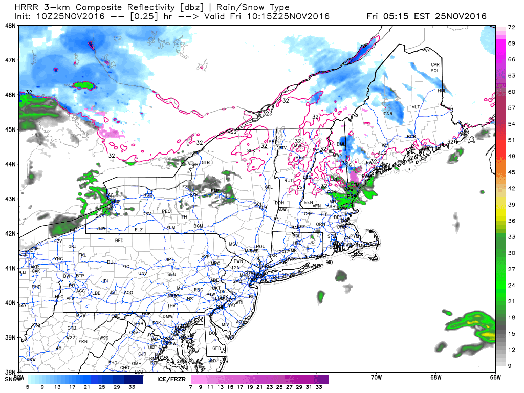
Today will feature mainly cloudy skies along with a medley of precipitation. This morning, the far north and mountains will see snowflakes, inland and foothill areas will see a mix of sleet and freezing rain, the coastal plain will see some freezing rain, and the immediate coast will start out with plain rain. By this evening all but the farthest north and west of mountains will be seeing plain rain with just a few holdouts of ZR up north. Rain will be heavy at times this evening and a good inch of water is expected to fall across much of the area.
HRRR Model Depiction Of Precip Evolution Today. Credit: Weatherbell
Rain winds down this evening and temps will rise as westerly breezes will break up the last remaining cold air and everyone will be near or above 40 degrees by midnight.
More rain/mix/snow arrives tomorrow evening and into Thursday before cooler air arrives this weekend.
Yesterday saw some cracks in the overcast, today will see the completion of that job at least along the coast. Look for mainly sunny skies SE of the mountains along with warm temps a little shy of 40 degrees. In the mountains, look for partly to mostly cloudy skies along with cooler temps a little above freezing. Winds look light as high pressure settles in and no precip is expected.
A medley of wintry weather looks to arrive tomorrow before a rainy rest of the week.
After a prolonged stretch of cloudy weather these past few days, today’s forecast finally features fairly widespread sun. Breaks in the overcast are already being reported across southern and western areas while the midcoast and NE mountains are still dealing with rain and snow showers as a result of an inverted trough. That will move out by mid day leaving almost everyone, except for the mountain upslope suspects, dry. Upslope sprinkles and flurries will continue on and off for much of the day as breezy NW winds develop. Gusts to 25 mph are expected. Temps today will follow recent trends with highs right around 30 in the north and a bit above 40 in the south as downsloping will exert its mild influence.
Our next chance for widespread precip arrives Tuesday in the form of *enter precip type here*.
Today will feature a continued lack of sunshine as weak storm systems swirl around. Look for cloudy skies, morning fog, and evening showers of both the rain and snow varieties depending on location. Starting with this morning, fog should slowly lift from now through noon when it should be mostly gone from all areas. A period of dry but cloudy conditions is likely between noon and late afternoon (4-5 PM) at which time showers are likely to develop. These will be rainy along the coast and snowy in the mountains with a variety of mixed precip in between. Coatings of snow are possible in the mountains but nothing beyond that is expected. We’ll return to dry and cloudy conditions later this evening.
Temps are forecast to range from around 30 in the far north to around 40 along the coast with light winds.
Our stretch of less than stellar weather will continue today as weak areas of low pressure swirl around. Look for cloudy skies and drizzle along with light rain and snow depending on location. The mountains will see morning light snow tapering to flurries and possibly freezing drizzle as ice crystals are removed from the snow producing layer aloft. The layer will resaturate this evening and light snow is expected to begin again around dinnertime. Temps in the mountains will remain mostly below freezing. At the coast, morning drizzle and fog will give way to afternoon rain showers. Highs along the coast will be in the mid to upper 30’s, possibly touching 40 along the midcoast. Inland areas will see morning flurries give way to afternoon rain showers as temps warm above freezing.
HRRR Model Idea Of Precip Evolution Today. Credit: Weatherbell
Here’s one interpretation of how precip evolves today. I think this model underestimates a moderate cold air damming signature today and thus is too quick to warm the mountains above freezing but otherwise I think it gives a good idea of the transition from morning light, mainly frozen, precip to afternoon steady, mainly liquid, precip.
A developing nor’easter will rumble by offshore tomorrow and will brush the area with some light rain changing to snow as cold air moves in. At this time, it looks like that storm will be too far offshore to bring any significant impacts.
As a quick side note, in case you missed the winter forecast I posted last week, you should check it out now to get an idea of what this winter may look like. The pattern we’re seeing now is already fitting into the idea I posted there!
Today will be chilly by recent standards and will also feature rounds of light precipitation in various forms. Look for areas away from the coast to see mainly snow while the coast sees a mix of rain and snow. Some light freezing rain is also possible near the coast. Snow accumulations will be in the 1-3″ range across northern NH and NW ME while most of the area sees a coating to 1″. The midcoast will likely be too warm to see any snow and light rain/drizzle is expected there. Highs will range from just shy of 30 in the mountains to just shy of 40 along the midcoast.
More light precip (mostly rain) is expected tomorrow with light snow in the mountains before heavier precip of undetermined varieties arrives Saturday.
Today will feature more of the cool weather we’ve been seeing this week as low pressure continues to spin well NE of the area. Look for light NW breezes to continue to govern the weather pattern and as a result temps and clouds will take on a typical upslope/downslope pattern. The mountains look to see mainly cloudy skies with highs near freezing while the coast can expect mainly sunny skies and highs near 40. No precip is expected.
More wintry weather is forecast tomorrow as light rain and snow moves in. A more substantial storm looks likely on Saturday though details on that are still unclear.
Today will feature more of what the past few days has brought with a mix of sun and clouds, occasional snow showers, and breezy NW winds. Highs will be chilly ranging from the mid 20’s in the mountains to the mid 30’s along the coast. Clouds will follow the typical upslope/downslope pattern as a result of the NW flow meaning that coastal areas look to see plentiful sun while the mountains see mainly cloudy skies. Upsloping will also be responsible for snow showers continuing in the mountains with light accumulations expected at higher elevations. NW winds will be breezy once again with gusts near 20 mph.
Snow fell across most of the region this morning with light accumulations even outside the mountains. Gusty WNW breezes will keep the snow going in the typically favored upslope regions in the mountains today with several inches of accumulation expected. Skies are forecast to be mainly cloudy for the mountains and inland areas as well as the midcoast while the coasts of SW ME and NH are likely to see some sunny breaks. Temps will be chilly and highs will range from the upper 20’s in the northern mountains to the upper 30’s along the coast.