Ferocious Wind And Rain This Morning

Hello everyone!

This morning’s weather will be dominated by the landfalling remains of what was once Tropical Storm Philippe. Satellite imagery shows this system SE of Cape Cod as of 4 AM and it is racing NNW towards the Maine coast. It’s this low that will bring hurricane force wind gusts to the coast between 6 and 8 AM. After this low passes, winds will turn southwesterly and howl even stronger for most people who didn’t get the full force of the southeasterly winds this morning. Widespread 45-55 mph gusts are expected even after the rain clears out. Temps will be mild, in the 60’s, this morning but will fall this afternoon as a cold front  moves through.

-Jack

Wind And Rain Develops Today

Hello everyone!

A major storm is on the way for tonight and tomorrow as Tropical Storm Philippe is set to race from Florida to Maine in under 24 hours, while merging with a powerful extratropical cyclone. If you’re interested in the meteorology behind this system, I broke it all down in last night’s weather.us blog discussion. I’ll have more updates for weather.us on Twitter and on the blog through the day today, this update will give a quick synopsis of what to expect for Western Maine and New Hampshire.

Rain will continue to develop from southwest to northeast today as tropical moisture surges into the region. SE winds will also pick up as low pressure develops to our west. The worst of the weather will hold off until early tomorrow morning, however.

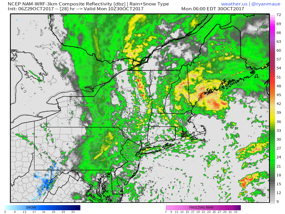
Tomorrow morning, the remnant core of TS Philippe will be making landfall in Maine, near Portland. Torrential rains (shown above in the simulated radar image) will cause flash flooding issues, and wind gusts near or possibly over hurricane force will result in downed trees and power outages.

Temps will be seasonably mild today, in the upper 50’s to low 60’s.

Rain will clear out midday tomorrow with gusty westerly winds bringing drier air into the region. Westerly winds could gust over 45 mph tomorrow afternoon, continuing the power outage threat.

For an excellent Maine-focused discussion, check out Mike Haggett’s blog post from yesterday afternoon.

For my thoughts on the system (regionally focused, not specifically about Maine/NH), check out my weather.us forecast analysis from yesterday afternoon.

I’ll be continuing updates on blog.weather.us and on Twitter through the day today, with my next update here coming tomorrow morning.

-Jack

The Calm Before The Storm

Hello everyone!

Today will feature the calm before tomorrow night’s storm, which will prove to be quite a good one. More on that in tomorrow morning’s update. Today, morning sunshine will give way to afternoon clouds as moisture begins to move into the area. Areas outside of the SE mountain slopes will stay dry, while upslope showers develop in those areas this afternoon. Temps will be cool as clouds develop and winds turn onshore, with highs generally sitting a few degrees on either side of 60. SE breezes will develop today, giving a preview of what’s to come tomorrow night.

-Jack

Cooler And Drier Today

Hello everyone!

Today will feature cooler and drier weather as our low pressure system departs to the northeast. Expect highs to range from the upper 40’s in the mountains to the mid 50’s along the coast. Morning westerly wind gusts will taper off this evening as high pressure is quick to build in ahead of the next system. Skies will start on the cloudy side, especially in northeastern areas, but full sunshine will take control by sunset.

Our next chance for a significant storm will be Sunday into Monday.

-Jack

Rain Continues Today

Hello everyone!

Rain will continue today as one last storm develops along the strong cold front that has brought us heavy rain for the past couple of days. Today’s rain will be of the steady and moderate variety, as opposed to the torrential downpours of recent days. Rain will slowly taper off from south to north this evening. Highs are expected to range from the upper 40’s in the western part of NH to the lower 60’s in eastern Maine. The discrepancy will be due to an area of low pressure moving up the NH/ME border. Behind the low, cold air will rush in on NW winds while warm SE winds will keep temps up ahead of the low.

Drier and cooler weather develops for tomorrow.

-Jack

Heavy Rains And High Winds Continue Today

Hello everyone!

Today will feature a continuation of last night’s heavy rains and high winds as a strong cold front stalls out over the area. Exactly how far east the front can make it before stalling will determine where the axis of heaviest rain sets up today, as well as if western parts of NH can break into some sunshine before the next storm arrives.

Current model forecasts show the front stalling across the eastern part of the area, from Augusta down towards Portland. This means that areas along and east of that line have the greatest chance to see heavy rains today as showers move north along and ahead of the front. Gusty winds will also continue ahead of the front, meaning that the midcoast is likely to see another day of 30-40 mph gusts.

Temps will remain mild region wide today with highs ranging through the 60’s.

Another storm will move north along the front tonight, bringing an additional round of heavy rain and gusty winds tomorrow before improving weather sets in for Friday.

-Jack

Turning Stormier Today

Hello everyone!

Our long stretch of warm and dry weather is finally coming to an end. A strong cold front will approach our area today, with stormy conditions beginning to develop this afternoon out ahead of the front.

Expect showers to develop during the day today, especially along the SE facing mountain slopes where strong upsloping will help to wring out moisture. A line of strong to severe thunderstorms will move into western NH later on this evening with wind gusts that could cause some damage. Storms will be weakening as they move east into Maine, where stable marine air will be located. Even the weaker cells will produce torrential rainfall that is likely to amount to a couple of inches in a short period of time. While rivers are near record low levels due to recent dry conditions, small streams and poorly drained areas could very well flood for a brief time tonight.

Farther east, winds will be driven by the larger frontal circulation as opposed to individual thunderstorm cells. Winds sustained over 30 mph, gusting over 40 mph are expected along the coastline this evening as the front approaches. These winds, while not strong enough to cause widespread issues, are capable of scattered power outages.

Additional upper level energy dropping into the front will bring more rain, especially for the coast, tomorrow.

-Jack

Warm And Cloudy, But Still Dry Today

Hello everyone!

A strong, slow-moving cold front is marching ever closer to our area today. While it won’t arrive in our area today, we’ll begin to feel its effects in the form of moisture returning on SSE winds. SSE winds are onshore for much of the Maine coast, so expect cool temps along the coast, especially northeast of Portland. The increasing moisture combined with the cool temps will lead to fog developing across much of the SE part of the area today. The mountains and foothills are likely to remain mostly out of the clouds, as SE winds will be downsloping as they move towards the Canadian border. The sunshine in the mountains will boost temps into the upper 60’s. While some drizzle is possible along the coast, organized precipitation will hold off until tomorrow.

-Jack

Cool In The East, Warm In The West Today

Hello everyone!

Today’s weather will be quite dependent on which part of the area you’re in. SW NH will bask in another day of late fall warmth with mostly sunny skies and light west winds. Along the ME coast, a cool and damp day is forecast with onshore winds becoming fairly breezy in the afternoon. Fog is likely to redevelop this evening along the coast as well. Highs will range from 60 along the coast to 75 in SW NH. While drizzle can’t be ruled out along the coast, no organized precip is expected.

-Jack

Warm And Dry Again Today

Hello everyone!

Today will feature more of the same unusually warm fall weather that we’ve been seeing for the past few days. Temps won’t be quite as warm as yesterday due to a weak cold front that drifted through the area last night. Look for highs to rise into the upper 60’s and low 70’s for most of the area. Winds will be light and out of the northwest today. Skies will once again be sunny and no precip is expected anywhere in the region.

-Jack