Warmer And Muggier With Thunderstorms For The First Part Of This Week

Hello everyone!

I will be embarking on a brief trip to the deep woods of Northwestern Maine this afternoon through Wednesday morning, so the next three days of weather information (today, tomorrow, Wednesday) can be found in this post as opposed to one per morning.

Today

Today will feature warmer temps, higher humidity, and the chance for some more pop-up showers and thunderstorms as a weak disturbance crosses the area ahead of a much larger frontal system over the Great Lakes. Expect high temps to range from 80 in the far north and along the Midcoast to a little above 90 in the typically warm spots of the interior. Dew points this morning are in the upper 60’s, which means this is officially a muggy airmass. As a result, heat index values will rise into the mid 90’s for southern areas, high enough to be concerning if you’re particularly sensitive to the heat.

3km NAM model showing widely scattered showers and storms this afternoon/evening across Northern Maine and New Hampshire

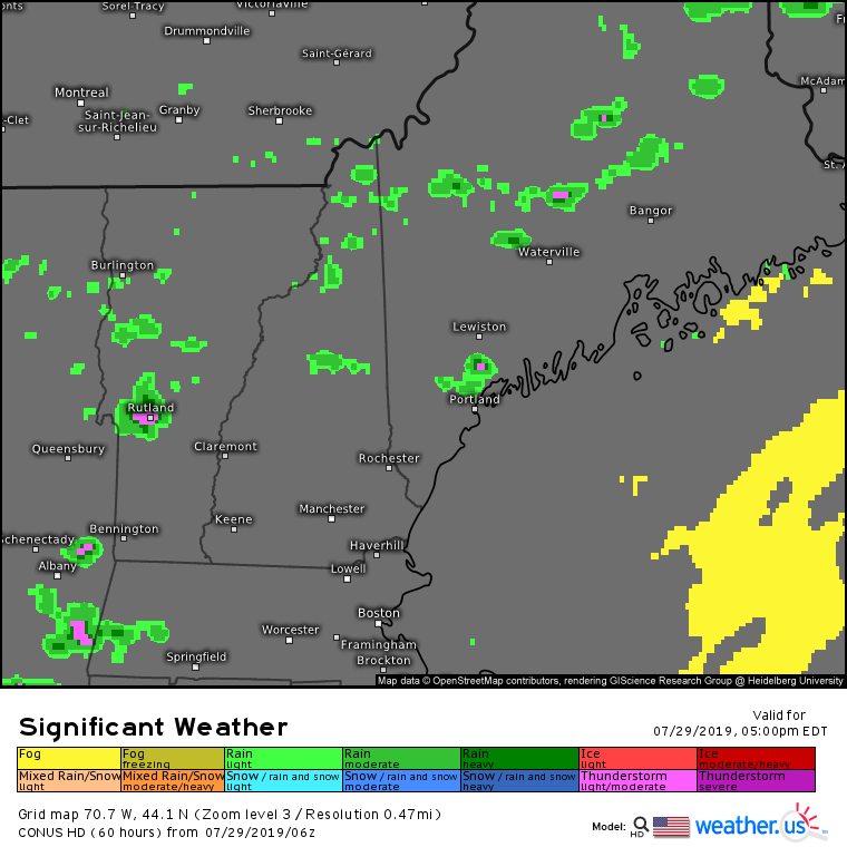
The muggy and warm airmass will provide fuel for some thunderstorms to pop up this afternoon/evening. As the model forecast above shows, not everyone will see precipitation, but those that do will receive a brief downpour and potentially a clap of thunder. Overall though, most places stay dry.

Tomorrow (Tuesday)

Tuesday will be the hottest day of the week as the cold front gets closer and pulls more warm air north ahead of it. Look for sunshine in the morning to heat things up well into the upper 80’s/low 90’s for all but the tips of the peninsulas (which will sit around 80-85). Dew points will remain in the mid to upper 60’s, which means more humidity and uncomfortably high heat indexes (likely 95-100 in southern areas). It also means more afternoon thunderstorms, though these are likely to be confined to the far NW mountains as well as western parts of New Hampshire that are closer to the front itself.

Wednesday

Wednesday will feature the passage of the cold front across the region, which means a reduction in the heat but a bump to both the humidity and our chances of thunderstorms. Dew points on Wednesday likely crack 70 along the coastal plain as temps rise into the upper 80’s/low 90’s. Farther north, the front will pass through earlier in the day meaning that temps will be lower than Tuesday. Highs in the mountains likely won’t get above 75-80.

Storms will develop in the north during the late morning hours and will slowly work their way southward through the afternoon. At the moment, it looks like there will be plenty of instability (fuel) for the thunderstorms, but not enough in the way of mid/upper level winds to be concerned about widespread severe weather. That said, all thunderstorms are capable of flooding downpours and dangerous lightning regardless of their capacity to produce severe criteria hail (1″ in diameter) or wind (gusts >58mph).

I will be back on Thursday morning with normal morning updates. If you’re looking for a sneak peek at the late week/weekend weather, it looks pretty great behind the front.

-Jack

Warmer With Some Thunderstorms Today

Hello everyone!

Today will feature warmer temps and increased humidity ahead of a cold front currently moving through the Great Lakes. The soupier airmass will provide fuel for some showers and thunderstorms later this afternoon/evening. Look for storms to get going between 2 and 3 PM over the far north and mountains before working their way south later in the afternoon/evening. Overall the severe threat will be on the lower side as the winds aloft you need to fuel severe weather will be relatively weak. That said, any storm is capable of some gusty winds during its decaying stage, and heavy rain/lightning are a dangerous combo that even non-severe storms produce. Storms will weaken as they approach the coastline later this evening.

High temps today will range from 75 along the midcoast to 80 in the far north to 90 in the typical warm spots inland.

-Jack

A Bit More Humid Today With The Chance For A Brief Shower Today

Hello everyone!

Today will feature increased humidity as dew points climb back above the 60 degree mark. That means that as temps warm into the mid 80’s over inland areas, there will likely be enough instability to support a brief shower or thunderstorm this afternoon/evening as an upper level trough passes overhead. We don’t have enough in the way of forcing or wind shear to worry about severe weather, but any storm that does pop up will bring heavy rain and dangerous lightning. Most of the region however will be staying dry as high pressure continues to slide offshore. Temps will be a little cooler along the coast where onshore winds will be developing this afternoon.

-Jack

Another Day, Another Round Of Awesome Weather

Hello everyone!

Today will feature more awesome weather as sunshine remains abundant, dew points remain low, and temperatures remain reasonably comfortable. Look for highs ranging from 75 in the mountains and along the coast to 85 in the usual inland warm spots. While that’s a little warmer than yesterday, dew points remain in the 50’s so it shouldn’t feel too bad. Enjoy the beautiful weather while it lasts, more heat will build into the region as we move towards next week.

-Jack

More Really Nice Weather Today

Hello everyone!

Today will feature more really nice weather as we continue to enjoy the Canadian airmass behind a large cold front offshore. A weak wave moving along that front has tossed some clouds towards the coast this morning, but sunshine will take over within the next hour or two. Aside from some fair-weather puffy clouds that develop this afternoon, clear skies will be enjoyed by all. Temps and dew points will remain locked in the ‘absolutely delightful for this time of year’ range, with highs in the low/mid 70’s in the mountains and along the coast. Temps will be a little warmer, in the low 80’s, inland but with dew points remaining in the 50’s, it will still feel pretty comfortable.

-Jack

Increasing Sun And Very Nice Temps Today

Hello everyone!

Today will feature increasing sunshine as a cold front continues to move off to our east. Behind that front, cool and dry air is filtering in from Canada with temps in the 70’s and dew points in the 50’s across the area this morning. We’ll tack on another 5 or so degrees this afternoon as the sun comes out, but the air will remain dry. Enjoy the beautiful weather, this is about as good as it gets this time of year!

-Jack

The Next Few Days + A Note On July

Hello everyone!

After a phenomenal several days hiking in the Alps, I’m back to the internet now. Because a connection strong enough to download the data I need to make a good forecast has been hard to come by, and may continue to be sparse for the rest of my trip, I’ve decided it’s probably easiest to plan on not posting until I get back to the states 7/24. For those currently supporting me on Patreon, I’ve found a way to pause that for the month since it would be wrong to charge for a service I’m unable to provide at this time. I’ll resume posting as usual on 7/24.

Before I head off on the next leg of the trip up to Germany, I’ll leave you all with a quick look at the next few days. If you want, continue scrolling down for a look at some of the pictures from this past week’s adventures.

Wednesday 7/3: Fair weather and seasonably warm temps around 80 in the mountains and 90 in Southern NH. Slightly cooler along the immediate coast.

Thursday 7/4: Basically the same as today but warmer. 85 in the mountains, low 90’s for most of the area away from the coast. Still calm/mostly sunny as high pressure meanders overhead. All clear for fireworks and other outdoor festivities.

Friday 7/5: Still mostly sunny and dry. Warmer again, mid-high 80’s for the mountains, low-mid 90’s for everyone else not on the coast. A couple SW NH spots may run into the upper 90’s. A sea breeze will bring afternoon relief to the shorelines.

Saturday 7/6: Cloudier as a cold front approaches. Expect afternoon/evening showers and thunderstorms. If enough sunshine develops in the morning to allow for building instability, some of these storms may be strong/severe. Clouds and storms will keep temps down a bit to 75 in the north and 85-90 in the south. As always, it’ll be a bit cooler near the water.

Fair weather returns Sunday and looks to continue into the first part of next week with temps near or a little above average.

Some pictures from the past week are below for those who might enjoy them.

A view of le Grand Balcon Nord, one of our alpine traverses in Chamonix

Mountaineers ascending Aguille du Midi (sadly it wasn’t us this time)

The Aguille du Midi cable car ascending in front of the Glacier des Bossons

Stopped by a bear’s house above the Col de Balme near Vallorcine. No bears appeared to be home at the time of our visit

Met a lizard overlooking the trail to Croix de Fer

Descending from Croix de Fer

Traversing snowfields near Col de Balme

Found a small glacial erratic-to-be in le Mer de Glace

The foot of the Glacier des Bossons

It’s been an amazing trip so far, and there’s much more to come! I’ll put some more pictures up here when I get back.

Have a great July everyone, and thanks for all your continued support of my little forecasting project and interest in Maine’s weather.

-Jack