Today will feature more in the way of unsettled weather as the upper-level low responsible for storms on Sunday and yesterday’s soaking rain remains close by. As of 5:15 AM, the steadiest rain is located over central and northern parts of the area from western Cumberland County north towards Sugarloaf. Expect new showers to pop up as we head throughout the day and temps drift slowly upward in response to whatever remnant energy from the sun isn’t reflected by thick cloud cover.
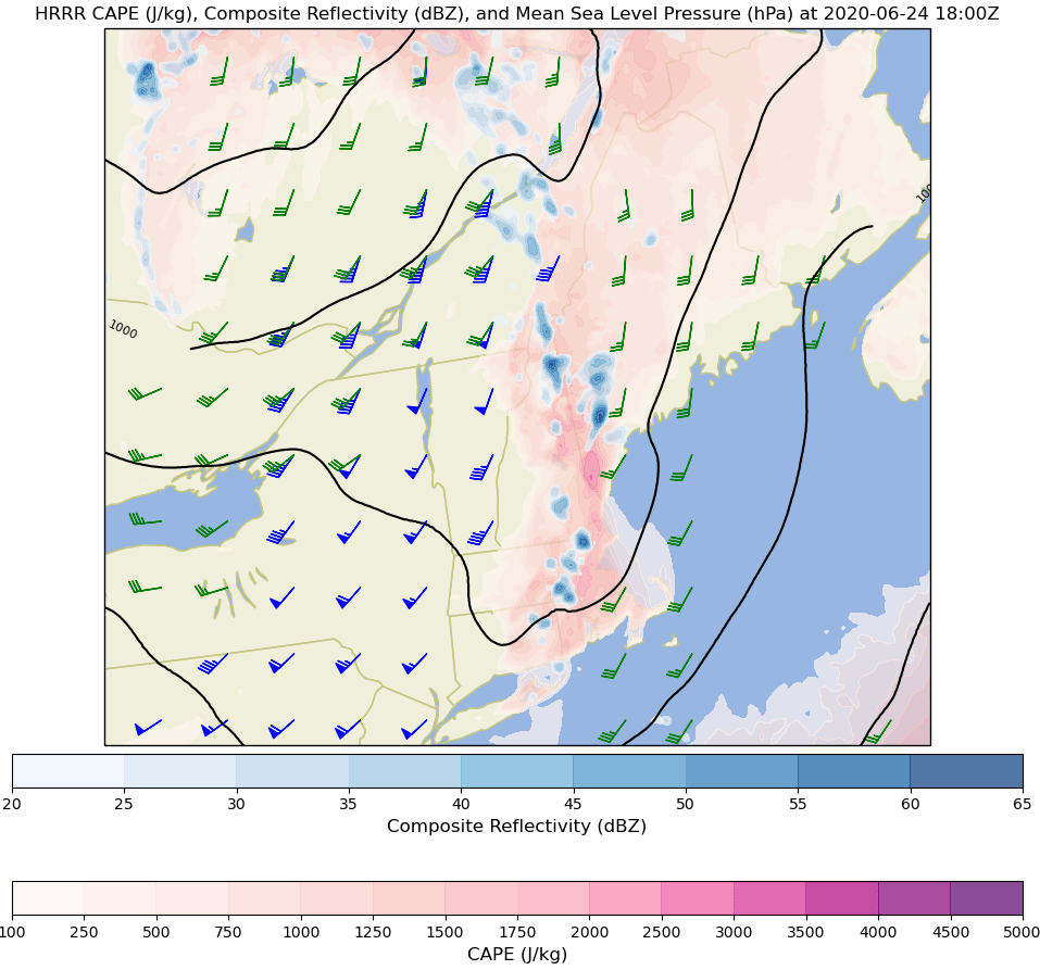
Here’s one model depiction of what the radar might look like this afternoon. Note that shower activity will be concentrated away from the coast where the best instability will develop. At this point, it doesn’t look like any of these showers will be strong enough to produce severe weather, but a few rumbles of thunder are possible.
Temps today will remain on the cooler side thanks to the cold air associated with the upper-level low and abundant cloud cover. Expect highs within a few degrees of 70 across the area. The northern mountains and Midcoast peninsulas will be coolest around 65.
Much of the region is now officially experiencing moderate drought conditions, so while today will be on the dreary side for most, the rain that will fall is sorely needed. Radar imagery this morning shows drought-busting downpours in progress from the mountains down towards Casco Bay. This region of moderate to heavy rain is rotating slowly counter-clockwise in response to forcing from an upper-level low. That means that the Midcoast is likely to see some rounds of heavier rain in the next couple hours while York County and parts of Cumberland County see precipitation taper off.
This morning’s steady rain will gradually fade to scattered showers and thunderstorms this afternoon. These are generally expected to be less intense than yesterday’s storms, but will be similarly widespread. Not everyone will get heavy rain this afternoon, but I suspect there will be more winners than losers given the favorable forcing for ascent and abundant moisture.
A few breaks of sun are possible this afternoon especially in southwestern parts of the area, but overcast skies will generally be in control today. As a result, temps will remain on the cooler side, ranging from the low/mid 60s in much of Maine to low/mid 70s in western NH.
Today will feature fairly widespread showers and thunderstorms in the afternoon as a storm develops to our south. This is actually an interesting setup in a number of ways, and if all goes well, parts of the region could pick up quite a bit of much needed rain.
We start off this morning mostly sunny except for some fog in the Midcoast and a few clouds up in the mountains. That sunshine is just what we’ll need to boost temps into the low/mid 80s across much of the region. The Midcoast, under persistent clouds and fog, will remain cooler as will the mountains. A few spots in southern NH may end up in the upper 80s. For those who end up above 80, there will be plenty of instability for showers and thunderstorms to develop this afternoon.
Those showers and storms will be popping up starting around 2-3 PM in the mountains. The best fuel for thunderstorms (pink/red shadings) will be found away from the coastline right along the edge of the sea breeze front. This is where the best chance of severe weather will be found. Today’s stronger cells could produce some damaging wind gusts especially up in the mountains.
By this evening, showers and storms are expected to coalesce into larger bands of moderate to heavy rain. This would be ideal for making progress towards alleviating our current drought.
Keep an eye to the sky if you’re headed outside today.
Today will feature generally quiet weather as an area of low pressure slides east through PA/NJ/NY. On the northern periphery of that low, we’ll see clouds increase in the next several hours especially in southern parts of the area where sunshine is currently being observed. Unfortunately, most of the rain associated with this system appears to be headed for southern New England. This is good if you have outdoor plans today, but bad for our current drought situation. Precipitation chances will be highest in southern NH (closer to the low) and up in the mountains where a few afternoon showers/storms could pop up.
High temps will range from 75 in the north, right along the midcoast, and in southwestern NH to 85 in southeastern NH and the coastal plain of Maine.
Today’s weather will look pretty similar to that which we saw yesterday. We’ll start off with a mix of sun and clouds this morning depending on exactly where you’re located. As of right now, the cloudiest spots are across the interior/foothills and the sunniest spots are right along the coastline and up in the mountains. A few isolated showers are drifting through the foothills north and east of Lewiston but otherwise, it is and will be a dry morning.
As temps warm and a southerly breeze brings some moisture in off the ocean, instability will develop this afternoon. This means that we’ll again be watching for some pop-up showers and thunderstorms. These showers and storms are most likely up in the mountains and right along the coastal plain. Without robust instability, a strong forcing mechanism, or much in the way of upper-level wind shear, no severe weather is expected this afternoon. Heavy rain and lightning will be the main threats with any cells that pop up.
High temps today will range from 75 in the mountains and right along the midcoast shorelines to 85 in southern NH.
A much nicer airmass will arrive in the region today behind yesterday’s cold front. As of 5 this morning, skies across the region are almost entirely clear (sorry about the remaining fog, Penobscot Bay, that’ll be out of your way in the next few hours) and dew points have returned to the range of acceptability (for this time of year, which is anything below 60F).
Our warmer and drier airmass near the ground will be accompanied by some cooler air aloft. That means this afternoon will see an increase in cloud cover as daytime cumulus pop up in response to the stronger vertical temperature gradient. As of right now, it doesn’t look like these clouds will be tall enough to generate any rain but a stray sprinkle can’t be totally ruled out especially up in the mountains.
High temps today will be pleasantly warm, ranging from the mid 70s up in the mountains and along the immediate shorelines to the upper 80s across much of the coastal plain and foothills region.
A cold front will approach the region today which means that showers and thunderstorms will become more widespread this afternoon. A few showers and storms leftover from activity in NY yesterday are moving into Vermont this morning, and may drop some rain in western NH over the next couple hours. The main round of showers and storms will arrive later in the day, beginning around 12-1 PM in Central NH before moving into Maine during the mid-afternoon hours.
Uncertainty surrounding the coverage and intensity of this afternoon’s storms primarily revolves around how much sunshine we’ll be able to get this morning. Most of the region is socked in with dense fog as of 5:30 AM which is far from conducive for thunderstorms. To get widespread storms that might have a risk of severe weather, we’ll need some sunshine. The mountains and foothills will see sunshine first this morning, so they have the best shot at more widespread thunderstorms. Temps there will range from 75 in the north to 85 in south-central NH. Closer to the coastline, fog will linger later into the afternoon and will hold temps to the upper 60s near Penobscot Bay and upper 70s along the coast near Portland.
Some of the stronger storms in the northern part of the region could produce a few damaging wind gusts, but overall the risk of severe weather today is low.
Showers and storms will fade this evening as the sun goes down and daytime heating is lost.
Today’s weather will look nearly identical to yesterday’s as winds across the region remain out of the south/southeast. This means that parts of the interior, especially southern NH, will be hot and humid yet again. It also means that the coastline will continue to enjoy reasonable temps, even though it’ll still be quite humid. Expect highs ranging from the low 90s in southern NH and parts of far interior ME (Fryeburg-Farmington) to the low/mid 70s along the immediate coast. The I-95 corridor will again see temps in the low to mid 80s.
Cloud coverage will also follow a pattern similar to what we saw yesterday. Low clouds and fog are entrenched across much of the region this morning, but they will burn off as the sun comes up. This sunshine will combine with the heat and humidity to support another round of widely scattered showers and storms in the mountains and in central/southern NH. Just like yesterday, the primary threats associated with these storms will be heavy rain and lightning.
Showers and thunderstorms will become more widespread tomorrow.
Today will feature another day of hot and humid weather across interior parts of the region (especially NH) while fog, low clouds, and onshore flow will keep the coastline pleasantly cool. Satellite imagery and the handful of observations we have from local airports suggests that most of the region is experiencing low clouds and/or fog this morning. As the sun comes up, expect this fog to burn off from NW to SE. The mountains should see sunshine develop fairly early in the day while the coastline will have to wait until early/mid afternoon (if sunshine is able to develop at all, which may not be the case especially along the Midcoast). As a result, temps in the mountains and interior parts of the foothills will head for the mid/upper 80s once again today. Most of NH will see temps spike above 90. The coastal plain meanwhile will remain pleasantly cool in the upper 60s (Midcoast peninsulas) to upper 70s (I-95 corridor).
Just like the past several days, expect showers and thunderstorms to develop over NH and far NW ME where heat, humidity, and forcing for ascent will combine most effectively. Just like the past few days, there is not enough wind aloft to produce a meaningful severe weather threat. Continue to watch out for (much-needed) heavy rain as well as lightning with any storms that pop up this afternoon.
Today will feature another day of warm and humid weather for most of the area as we remain on the wrong side of a frontal boundary over the Plains. Expect high temps to reach the low/mid 90s once again in southern NH as well as some parts of interior Maine. The mountains will also remain warm with highs in the mid/upper 80s. Meanwhile, the coast will get a welcome reprieve from the worst of the heat as a backdoor cold front slips west.
That front is showing up well in current observations this morning as Rockland is reporting a temperature of 58 while Portland sits at 71 and Portsmouth NH is already up to 77.
Also note the cooler temps inland over northern and eastern Maine (64 in Bangor and 63 in Millinocket which both saw temps above 80 this time yesterday).
The impacts of this front on our weather for later today are evident when looking at forecasts for 2m temperature (shaded in the map below) and winds (the little barbs in the map below).
Note the onshore flow (winds blow towards the end of the long side of the barbs, so those over Maine with the long side oriented NW/SE indicate winds blowing from SE to NW) over Maine bringing cooler temps (70s) inland later this afternoon. Unfortunately, there will still be plenty of humidity to go around (dew points over 65 indicate really sticky air). The cooler air and high humidity will combine to produce conditions favorable for fog formation.
Satellite imagery confirms this idea and shows a thick fog bank drifting southwest behind the front. I suspect that this fog bank’s advance will be slowed by daytime heating for most of today but fog will likely continue moving west this evening. Parts of the Midcoast (especially the tips of the peninsulas) may remain under fog and/or stratus (low clouds that do not reach the ground) for most if not all of today.
Much like yesterday, our warm and humid airmass will support afternoon showers and thunderstorms especially in the mountains and NH, both of which will be on the warm side of our backdoor cold front. That front should prohibit much if any storm development in coastal or interior Maine (the exception being the far northern mountains). Just like yesterday, there will not be enough upper-level wind to be concerned about severe weather with these storms. That said, heavy rain and lightning can still be dangerous especially if you’re outside when storms arrive.