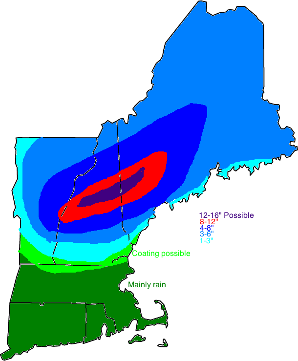
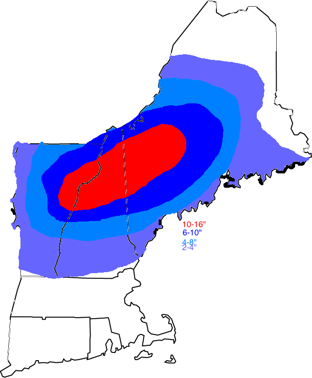
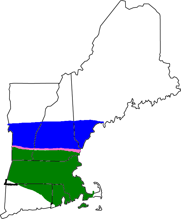
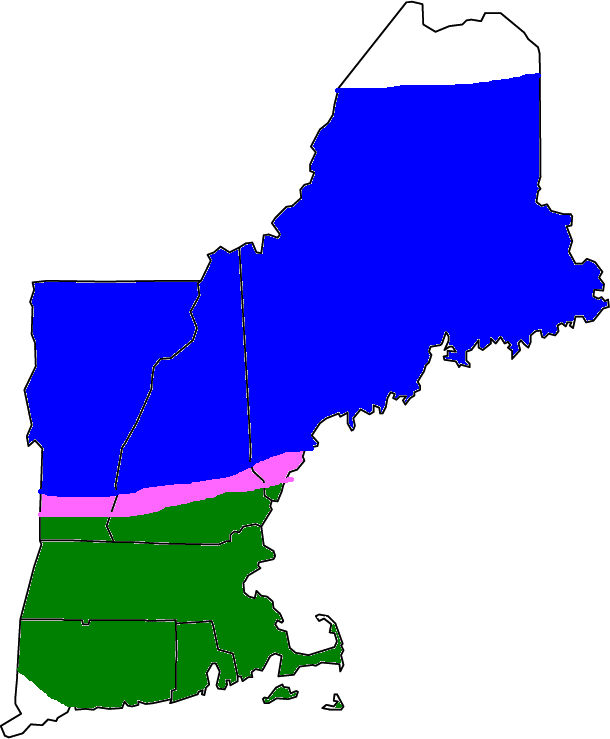
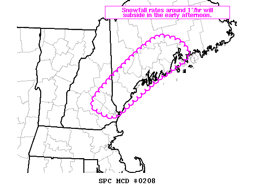
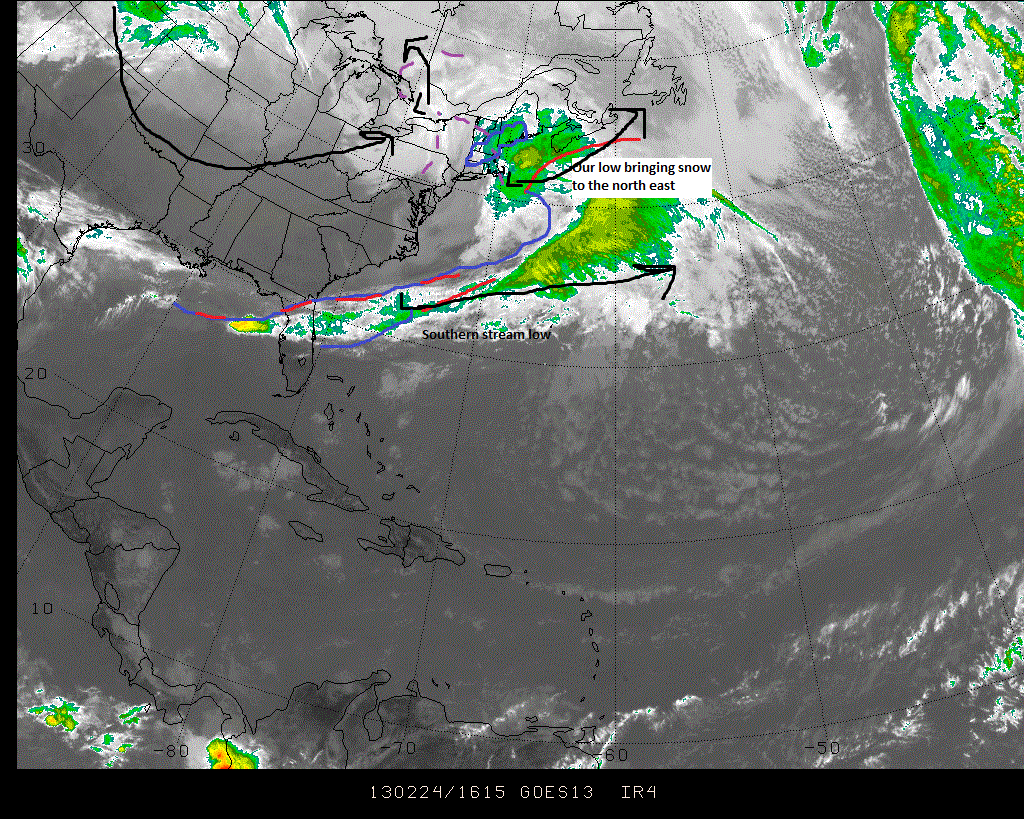
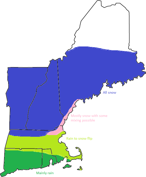
This storm is over the Gulf Of Maine and is moving east. It will keep clouds and snow showers in the forecast though the weekend and into early next week but clears out in the latter part of next week. Beyond that, I see no big storms as a ridge of high pressure takes over.
With snow changing to rain along the coast, the storm is pretty much done. Look for another 2-4″ in the mountains and 1-3″ a little closer say Farmington etc. Winds will be steady out of the northwest but not insane. I’ll be back with updated pages etc. this evening.
We have an interesting situation unfolding. There is a coastal front that has developed along the Maine/ NH coast that will be the difference between a foot and 4″. The front is situated slightly south of Casco Bay running inland roughy near Saco. We will watch the wind direction and this front as the day goes on. I’ve shifted totals a little based on the latest trends as well as observations.
This one will be tricky. Thats the one thing I’m certain about. Below is my thinking and analysis of the new data I’m receiving.
Precipitation will likely move in tomorrow morning. Snow will overspread the area tomorrow and could mix with rain along the immediate shoreline south of Portland. There will be a strong easterly wind that will bring in a marine airmass. This airmass will likely take over coastal and southern sections sometime wednesday night. The main low will be moving to the NNE through the Great Lakes while another low will develop and swing northwest across NYC. Then this low will stall as yet another low develops in the Gulf of Maine. This low will stall as it absorbs the low to the west. This transition will take place thursday and we will transition to all snow. The rain/snow line will be CRITICAL in determining the amount of snow one gets. It will probably come down to a few miles between the 12-14″ amounts and the 3-8″ amounts. I will do my best with a snow graphic but amounts will ultimately be determined by the exact rain/snow line location.
Snow map.
We will be watching a few things that will ultimately determine the location of the rain/snow line. One factor is mentioned above; the wind direction. If the wind is out of the north, cooler air from the north will stay in place. If the wind is out of the east, the warmer maritime airmass will infiltrate the region bringing a change/mix with rain. Another thing we will be watching is the placement of the low. The low placement will determine the wind direction. The low will move to the west on wednesday bringing an easterly wind to the region. Cold air will stay locked in place over inland areas due to a phenomenon called cold air damming. This is where the entire atmosphere is below freezing and the wind direction is out of the north in all levels of the atmosphere locking th ecold air in place effectively damming the warm air advance. This will be critical in determining the precipitation type and snowfall amounts.
Below I will give an approximate timing outline of the storm.
In the below images, blue indicates snow, pink indicates a rain/snow mix, dark green indicates rain and light rain indicates frequent rain showers.
Tomorrow
Tomorrow night
Thursday
Thursday night
Friday
Friday night
Saturday
Winds will be a factor though mostly inland with the low level jet. An inversion at the coast will keep the winds from mixing down a ton. Look for power outages as this will be a wet, heavy snow.
-Jack
We have a very interesting forecast ahead of us today. There will be a storm system coming in from the west that will overspread snow into the region tomorrow. The warm front will initiate a strong east wind off the warm water which will turn the coast over to rain. This however will be tricky because it will only be a difference of a few degrees that changes us to rain here at the coast. If this thing moves ever so slightly to the south, we’d get a lot more snow at the coast.
Snow map as of now.
The entire region will flip back to snow wednesday night and there may be mixing on thursday but it looks like a new storm center will form to the SE trying to bring in cooler air. I will have a new post tonight here and on my other sites tonight as well as updated pages.
-Jack
With 10″ in Gorham, 8.5″ in Winslow and 7.3″ here in Yarmouth, this storm has surprised me tons. The forcing is great and a last minute track shift has required me to write this now. I have to update several of my maps to reflect the changing conditions. This will be the last post until tonight if that is even needed.
Upped snow totals a tiny bit due to the increased snow rates that are due to the strengthening of the low a little earlier than expected.
Other than the snow totals, expect the winds to be a little higher as well. Since this is a heavy snow, power outages are certainly in the cards.
What a wild ride this has been in regards to amounts, source of amounts, low placement etc. We now have a low pressure center moving ENE that is located about 150 miles SE of the Cape. Regardless, its associated trough will bring snow. This trough will set up over the region today and sit there not moving until evening. Due to the non norlun nature of this trough (thank goodness!!), I am confident with my amountsthat have been upgraded and are shown below.
Snow Map.
Precipitation type map.
The upgrade in snow totals was due to the trough being slighly stronger than expected. As a result, the snow rates will also be higher than expected leading to reduced visibilities and slick roads.
-Jack
Sorry for the late updates as there was so much data coming in I could hardly keep up. Anyway, not much has changed and I have come up with a couple maps depicting the impacts of this storm.
Snow Map
Precipitation type map
-Jack
What a change over the past few days! First we were looking at the potential for a foot of snow from a powerful ocean storm and now we are looking at 6″ from its wicked inverted trough. Remember that inverted or norlun trough from earlier this winter? They are impossible to predict where they will set up until they actually do set up. Now I am thinking it will set up right near Portland or maybe a little south. Either way, there should be snow breaking our today from “ocean effect” or lake effect snow but over the ocean. Ocean effect snow tends not to be as heavy as lake effect and that is what we will see today.
There is a developing low off the Carolina coast that is moving ENE. This low will skirt too far offshore to have too much of an effect. its norlun or inverted trough however will. This troughs are notoriously impossible to predict as we saw earlier this year. Right now my thoughts are that it will dump a sufficient amount (6″) to many across southern Maine. My snow map is below.
Snow map.
Check out my other two sites for town by town forecasts for the snow. Those will be updated with the 18z runs tonight. They can be found at the right of my page.
-Jack