Special update this evening to bring you up to date on yet another storm that will graze us with some light snow tomorrow night into Monday morning. This storm will, like many this winter, develop in such a way that eastern areas as well as southern areas will see the most snow.
12Z GFS Showing The Storm To The NE And The Moisture To The SE At 7 AM Monday Morning. Credit: Weatherbell
As we have seen many times this winter, the storm will be developing too late to bring significant snowfall to the region however, with snow just coming to an end across coastal areas Monday morning, the commute will likely be slick. Snow moves out during the midmorning hours Monday before clearing takes place Monday afternoon.
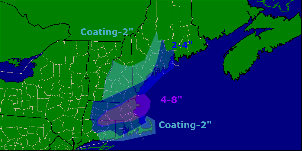
Here are my thoughts regarding snow accumulations. The Boston area looks to be the jackpot yet again while northern areas miss out.
Another snow event looks to arrive on Wednesday and may involve some mixed precipitation for southern areas. More details later.
Today will feature another quiet day in the weather world making this day number three in a row without accumulating snow. The last time this happened was January 20-23! Expect a bitter cold start this morning, where winds have gone calm temps are below zero, and where a light breeze still blows, single digits are widespread.
Once again this morning, we are seeing some very sharp temperature differences caused not by inversions, but very localized changes in wind conditions. Where winds have gone calm, temps have dropped significantly below zero. Where a light breeze still blows, temps are much warmer. Take a look at a few observations from this morning.
Here is a look at region-wide temps this morning. I have circled some of the sharpest couplets in purple as well as the blue and red examples.
Here is the sharpest contrast I could find this morning. The difference between the two locations, approximately 10 miles at nearly the same elevation. The one difference? One station has a 3mph breeze while the other is completely calm.
Temps rebound very quickly this morning as the sun comes up bringing highs into the 10’s up north and 20’s in the south under light NW breezes. Some high clouds are possible by evening across western sections but clear conditions should last throughout the daylight hours today.
Snow makes a return tomorrow evening, I’ll have details in another post tonight.
Another pretty mellow day weather wise today as high pressure builds in. Expect light winds, mostly sunny skies, and relatively mild temps. Expect highs in the 10’s up north and 20’s down in the south today which will feel pretty good under the high sun angle of late February. Expect a little dripping from the roofs and trees today as things heat up which will serve as a happy reminder spring really is on the way.
If you need something to cheer you up on yet another bitterly cold morning, a sizeable storm missed us. The storm that brought snow and ice to the deep south will be passing by well offshore and the only impacts we will see will be an increase in clouds especially over southern areas. Areas SE of Boston will get in on some snow accumulating 1-3″. Temps will be cold but not frigid, in the 10’s up north with 20’s south.
6Z RGEM Model Showing A Storm Missing To Our South This Afternoon. Credit: Weatherbell
Clouds clear out tonight as the storm moves away and sunny but cold conditions look to make a return for tomorrow and into the weekend.
No significant storms are on the horizon as of now but no significant warmups are either.
Snow is currently in progress over areas NE of Portland with the heaviest precip centered to the east of Brunswick. Expect light to moderate snow to end before dawn for areas to the west of Bath with snow sticking around through around 9 AM for areas to the east of there.
After snow moves out this morning, NW winds will take over and we will begin the upslope/downslope cycle where the mountains squeeze out the moisture in the air causing clouds and flurries while the foothills/coast sees all the remnant dry air and thus clearing. The moral of the story – mountain clouds/flurries, coastal sun. Temps will be in the 20’s for most with some 30 degree readings possible along the coast.
Special update this evening to cover another Norlun trough type setup that looks to bring another round of light snow tonight and into early tomorrow morning. While the heavy snow bands usually associated with Norlun troughs will remain mostly offshore, an axis of shifting winds with reasonably impressive instability and some lift too will make an appearance mainly east of Brunswick tonight into tomorrow morning.
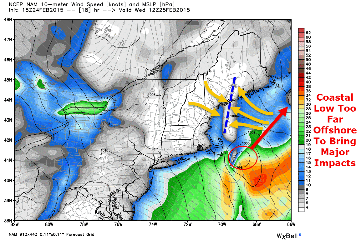
18Z NAM Showing A Distinct Wind Shift Line (Orange Arrows/Blue Dashed Line) Over Midcoast Maine At 7 AM Tomorrow. Credit: Weatherbell
A low pressure area that brought snow and ice to the southeast US will move too far offshore to bring major impacts though a Norlun trough, basically a wind shift line, will extend to the NW of the storm bringing coastal areas some snow. Snow will be concentrated between 11 tonight and 9 tomorrow morning.
12Z GFS Showing Intense Upward Motion Over Midcoast Maine At 7 AM Tomorrow. Credit: Accuweather
While snow will mainly be light, especially west of Brunswick, some moderate to even heavy bursts of snow are likely across Midcoast areas. The map above shows intense upward motion across Midcoast areas tomorrow morning signaling bands of heavy precip are possible. The areas most at risk for heavy precip will be east of the Bath/Brunswick area.
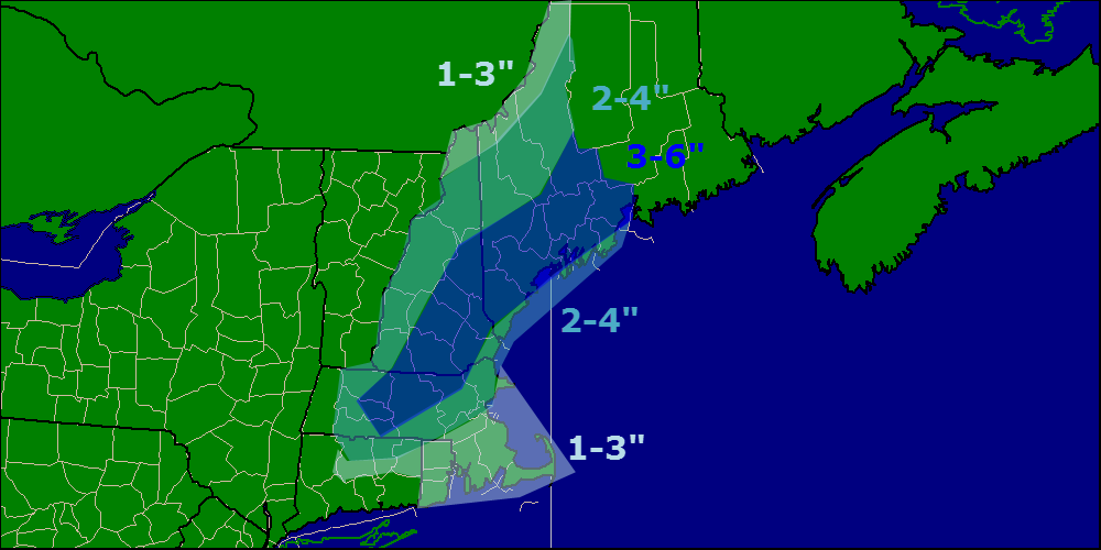
Here is the expected snowfall from this event. Not a lot, but the driveway will once again have to be cleared especially over eastern areas.
@SurfSkiWxMan@capecodweather , it's a hybrid NORLUN.. impressive lift/instability..no question there will be +SN, question is for how long?
In case you were wondering if this event was a Norlun trough, Weir Lundstedt, one of the two ‘discoverers’ of the Norlun trough (he represents the ‘lun’ part of Norlun) confirmed yesterday evening this did in fact look to be a hybrid Norlun event.
It’s really cold out this morning. No, really cold. Temps everywhere are below zero, even at the coast. Most areas, except for the outer islands and peninsulas are in the double digits below zero and 20 below is not uncommon region wide this morning. The good news is that the wind has died down so at least we won’t have to worry too much about wind chill. Regardless, bundle up if you must venture out this morning.
Temps will continue to drop until a little after 7 and will then rise swiftly as the high sun angle contributes to more effective heating. Some mid and upper level clouds will move in this afternoon and some coastal areas could see a low cloud deck move in as well later in the day but otherwise, another bright and blue one region wide today.
One interesting little note on our temp map this morning (off NWS’s Enhanced Data Display) are the numerous, very sharp inversions. Inversions are very shallow warm layers that basically lock away patches of air at the surface and temporarily prevent them from being influenced by the rest of the atmosphere. There are several great examples of that this morning.
Wiscasset (the -21 reading in the red circle) sits at an elevation of 53 feet while Nobleboro (the -9 reading in the red circle) sits at 126 feet. While they aren’t far apart (just 10 miles) and aren’t drastically different in elevation (a mere 73 feet), the subtle differences of their locations and especially elevations have made an enormous difference in their temps this morning. Go up in elevation just a little bit and you may find it’s quite a bit warmer this morning.
More snow is coming in tomorrow though it will be mainly light. More details in posts to come.
Today will feature the passage of an arctic cold front early this morning which will cause winds to pick up out of the north west today. Temps will be dropping through the 10’s today before dropping below zero tonight. By this evening temps will be in the single digits and wind chills will be well below zero. Wind chill warnings and advisories are out due to dangerous wind chills during this time. Looking on the bright side, skies will be mainly clear today after a few morning clouds move out.
HRRR Model Showing Wind Chills Well Below Zero At 7 PM. Credit: Weatherbell
Looking ahead, our next shot for some flakes looks to arrive Wednesday. Don’t worry, snow showers and maybe some light snow is looking like the most likely outcome at this point. Warmer temps and some mixed precip are looking more and more likely for the weekend.
Today will be an interesting one for sure as our storm pulls away. This morning expect clouds with a few lingering flurries mainly over Midcoast Maine as well as York County. Any leftover snow activity should be moving out in the next hour or two so the digging out can begin. Temps this morning are mild by comparison to previous weeks, 10’s inland and 20’s elsewhere with even a few 30’s showing up along the immediate coast!
Temps will warm even more today as a cold front comes through. Let’s just say the airmass behind the front isn’t all that cold… What the front does is basically slices and dices the cold airmass that is in place this morning so that it can move out of the way (notice the warm air that tried to work in last night was met with little success). As a result, temps will rise into the 30’s for everyone with readings near 40 along the coast!
For Portland, today will likely mark the first day since January 5th that the temperature has been at or above average.
NWS Radar Image Showing Snow Moving Out This Morning
Our mild temps today do not last as another cold front moves through this evening. Winds will pick up tonight as the cold air moves in and we go back to the bitter cold. Our next chance for snow arrives Wednesday and it looks to be in the form of snow showers or maybe even light snow.
Clouds will be on the increase today as yet another storm approaches from the west. Expect a very chilly start with most areas seeing double digits below zero this morning. However, temps will warm swiftly during the day as light southerly winds bring in warmer air. Most of us will end the day in the 10’s to low 20’s.
Snow will begin in the afternoon hours and will spread east during the evening. Expect a light snow for most areas with some moderate bands working their way in along the coast in the evening hours. Inland areas see mainly a dry and fluffy snow though some wetter snow is possible early tomorrow morning. Coastal areas see heavy wet snow and then have a shot at some rain too. This combined with the snow we’ve already had this winter will put a tremendous load on roofs so please shovel your roofs off today.
HRRR Model Showing Snow Approaching From The West This Morning Before Spreading Across The Region This Afternoon. Credit: Weatherbell
By evening, everyone is seeing snow, moderate at times, with temps slowly rising through the 20’s. It will be a race between the departing precip and the warming temps to see who gets rain. Most of the precip is out of here by midmorning tomorrow and only the islands/peninsulas should see rain by then.
Almost everyone goes above freezing for the first time in quite a while tomorrow afternoon after the ‘cold’ front comes through and shifts winds to the west. This will act to mix out the cold air that is in place and thus cause temps to rise. This is because the cold air that is in place during the storm is allowed to be in place because the air is not all that turbulent. The air from 10,000 feet is not going down to 5,000 feet and vise versa. Only when the front comes through and the air is moving up and down as well as horizontally can you bust open the cold dome that is in place.
Here is my thinking as to snowfall accumulations. On the south side of the 3-6″ zone accumulations will be limited by mixing with rain/freezing rain. It should be noted that since ground temps are so cold, any rain that falls will freeze on exposed surfaces like plowed roads or driveways so beware of icy spots if rain falls.