Today will feature the passage of a strong cold front which means a morning of heavy rain/gusty winds and an afternoon of sunshine/pleasant weather. Rain is ongoing across the region this morning, with the heaviest falling over the mountains and western NH while much lighter rain falls closer to the coastline. That’s pretty much the trend to expect until 8-9 AM when the front itself arrives and brings a round of downpours for everyone. Ahead of and along the front, wind gusts could top 50 mph so scattered power outages are possible. As per CMP, about 7800 folks are without power as of 6:15 AM. That number will continue to increase until winds die down and rain moves out late morning.
Weather conditions will rapidly improve this afternoon as west-southwesterly breezes bring dry air into the region. Expect sunshine to develop quickly around/after noon as dew points slide quickly into the 40s and low 50s. The airmass moving into the region will be a bit cooler, but the cooling effect of the incoming airmass will be roughly offset by the warming effect of the sun so temps will stay steady in the upper 60s to low 70s especially across the coastal plain. Cooler air will work into the mountains more quickly and since upslope clouds will limit the amount of solar heating possible there, temps will be a bit cooler in the mid/upper 50s.
More cool and dry weather is expected tomorrow before our next shot at rain arrives Friday.
Today will feature continued warm and humid conditions as a tropical airmass continues to flow north into our region from the Gulf of Mexico. Just like yesterday, most of us will start out with low clouds and/or fog before patchy sunshine develops in some inland spots. As you get closer to the coast, your odds of sunshine will decrease. We will see some scattered shower activity develop today, especially this afternoon/evening and especially in NH. Overall though, most of us will stay mostly dry until later tonight when heavy rain begins to move in from the southwest. Rain will be heaviest tomorrow morning as a cold front swings through. We’ll also have to watch out for some gusty winds, though it’s not quite clear if we’ll be able to tap into enough of the strong wind aloft to get concerned about power outages. Right now, I think the concern is relatively minimal.
High temps today will range from the mid 60s along the coastline to the upper 70s or low 80s in central NH.
The theme of this week’s weather will be much-needed rain as a series of disturbances bring tropical moisture northward into our region and provide a bit of forcing to get that moisture from vapor form into liquid form. Early this morning, most of the area saw a nice burst of heavy rain from a batch of showers moving north. A few spots north of Waterville/Farmington will get these showers in the next hour or so. Then most of the region will remain dry while scattered showers continue moving onshore east of Portland. Even in this area, the whole day won’t be a washout but rain will make an appearance from time to time. It looks like the best chance for rain will be early/mid afternoon.
These showers won’t bust our drought, but there are hints at a more widespread heavy rain event Tuesday-Wednesday that might be able to make some more meaningful progress. Fingers crossed!
Skies today will look fairly similar to yesterday with low clouds and/or fog along the coastal plain while patchy sunshine develops inland. High temps will range from the mid 60s along the Midcoast to near 80 in central/western NH.
We have a bit of a late-season warm/humid pattern to deal with starting today and continuing through the first half of the upcoming week. The bad news? Well, it’s going to be warm and humid. The good news? This pattern will support some extremely beneficial rain later in the week. I’m not quite sure exactly how much we’ll get, and it’s unlikely to erase our drought, but anything helps at this point.
This morning, a fog bank has taken over most of the area outside the mountains and some portions of the foothills. Visibility is significantly reduced in the regions impacted by this feature, as you might expect. I’m thinking this fog bank will evolve in a somewhat similar fashion to what we saw yesterday. Inland areas should see the fog burn off by midmorning while the sunshine crawls towards the coast during the late morning/early afternoon. Most spots outside the Midcoast should see at least a couple hours of partly/mostly sunny skies this afternoon. With very humid air moving over very cold water, I’d expect to see the fog hold fast along the Midcoast especially as you head down the peninsulas.
High temps today will range from the mid 60s along the Midcoast to the mid 70s up north to the low/mid 80s in the usual southern NH/SW ME warm spots.
Today’s weather will continue our recent stretch of above-normal temps as warm air flows north across the entire East Coast ahead of a cold front out in the Plains. That warm airmass is also bringing tropical moisture north into the region, and we’ll be feeling that in the form of higher humidity starting tonight/tomorrow. This morning, we’re feeling that increased moisture in the form of a fog bank that has set up over southern NH and the coastal plain of Maine. As the sun comes up, we should see this fog burn off but given that the southern edge of this fog bank is way down along the Gulf Stream, the immediate shoreline and the Midcoast might not see much if any sunshine today.
High temps will range from the mid 60s along the Midcoast to the mid 70s up north to the low 80s in interior southern NH. Aside from some patchy drizzle in the fog bank, no precipitation is expected today.
Today will feature another day of mild weather as high pressure slides to our east and winds start shifting around to the south. High temps will peak near 80 in southern NH and interior parts of SW Maine where southerly winds are not onshore. The Gulf of Maine will keep temps cooler (mid/upper 60s) along the coast and especially the Midcoast. Cooler temps (low/mid 60s) will also be found farther north. Skies today will see more sun than clouds area-wide.
Mild weather will continue today as westerly winds bring warm air into the area from the Great Lakes region. The westerly flow will also favor warm temperatures especially along the coastal plain due to downsloping off the mountains. Look for high temps ranging from the low/mid 60s up north to the upper 70s/low 80s in the south.
Satellite imagery this morning shows clear skies across the region with two areas of mid/high clouds located to our northwest and southwest. As the day goes on, some of those clouds will wander into our area so we won’t be able to enjoy perfectly sunny skies all day though there will be plenty of bright hours especially closer to the coast.
The powerful remnants of Hurricane Teddy will retain a strong influence over our region’s weather today as the system drifts slowly east along Nova Scotia’s southern coastline. High-level clouds from the storm are scattered across eastern/northeastern parts of the area this morning and will slowly fade away to sunshine as we move through the rest of the day. Westerly/northwesterly breezes behind the storm will carry warmer air into the region due to a quirky pattern in the mid-levels. Either way, temps will be warmer than usual today, ranging from the low-mid 60s up north to the low-mid 70s south.
That big Canadian high pressure area we talked about yesterday will sit squarely overhead once again today. That means we’ll see light winds, cool temps, very low humidity, and sunny skies. Expect high temps to range from around 55 in the north and perhaps right along the shoreline to the low 60s inland/farther south. No precipitation is expected again today.
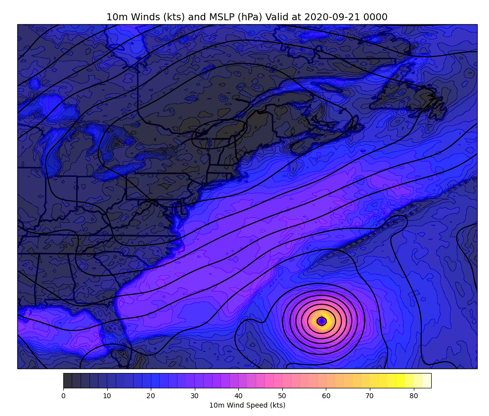
Well to our southeast, Teddy will begin the process of extratropical transition today. The animation above shows how its wind field will dramatically expand and briefly intensify as it interacts with the cold front/upper-level trough to its north before the entire circulation fades over cooler waters on Wednesday.
The primary impact for our area still looks to be big waves especially tomorrow evening.
The powerful Canadian high pressure system we’ve been watching for the past few days is now passing over Montreal and is headed slowly southeast. Because we’re closer to the center of the high, we’ll see northerly/northeasterly winds settle down a bit today. We’ll still get to enjoy the cool temperatures and sunny skies associated with the system, though a pocket of cool air aloft will support some afternoon cumulus clouds popping up in response to daytime heating. None of those clouds should be tall enough to drop any rain. High temps today will be quite similar to those we saw yesterday, ranging from the mid 50s in the north to the low 60s in the south.
Teddy is still on track to move well to our east tomorrow and Tuesday, bringing a period of powerful swells that begin to arrive today before peaking in intensity on Tuesday evening.