Hello everyone!
It’s another active weather day out there today so for the full details on the forecast please click on over to my writeup on Western Maine Weather.
-Jack

Hello everyone!
It’s another active weather day out there today so for the full details on the forecast please click on over to my writeup on Western Maine Weather.
-Jack
Hello everyone!
We will have wild ride weather wise this week with cool temps and flurries to start followed by a wet and wild Christmas Eve followed by a return to colder temps.
Here is a quick overview of this week’s weather. I’ll have more details on the Christmas Eve storm tomorrow.
Mon/Tues: Mostly cloudy skies with temps mainly in the 30’s. Flurries possible along the coast. Generally
Wed: South/Southeast wind strengthening and bringing in warmer air. Highs rising into the 40’s and 50’s by evening along with a heavy, windswept rain.
Thurs: Brisk west wind along with some leftover flurries especially in the mountains. Temps falling from the 40’s in the morning to the 20’s and 30’s by dusk. Some partial clearing is possible over SW areas.
Fri: Cool and clear, temps in the 30’s for the most part.
-Jack
Hello everyone!
Today will be a cool and cloudy one for the mountains and southern areas due to stubbern low level moisture. Temps will be cool but not cold with most areas rising into the 30’s with at least partial sun. The mountains however will stay in the 20’s under mostly cloudy skies. For the full update written my me over at Western Maine Weather, CLICK HERE.
-Jack
Hello everyone!
Today will feature some light to moderate snow to start as low pressure passes off to the east. Expect meaningful accumulations to be confined to the north and mountains with 3-6″ possible for the Sugarloaf area. Almost everyone sees some sort of accumulation even if it is only a coating. Most everyone, with the exception of the mountains, will see this morning’s snow melt as temps rise into the 30’s and 40’s. NW winds will be breezy today so temps will feel a good 5-10 degrees colder than they actually are.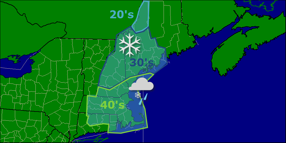
-Jack
Hello everyone!
Today will feature a not-so-nice day in New England as a storm system intensifies to our south. Expect a round of precip to move in this morning as low pressure approaches from the south. The coast will see all rain while the mountains see some snow/sleet/freezing rain in addition to a little rain. Everyone changes back to snow tonight with amounts ranging from 6-8″ in the mountains to a coating at the coast. Snow moves out early tomorrow morning.

-Jack
Hello everyone!
Today will feature the return of the clouds along with the chance for some showers and flurries. How any precip reaches the ground (snow/rain etc) will be determined by location. There is a better chance for liquid at the coast while inland areas see more snow. Temps will be cooler today as we sit under lots of clouds thus limiting the heating effect of the sun.

-Jack
Hello everyone!
Today will be a great day weather wise with clear skies, light winds, and relatively mild temps. Read my full update on WMW for more details.
-Jack
Hello everyone!
Today will feature some morning snow showers aligned in a north/south band from Rangely to Auburn to Portland which will drop an inch or two before moving out later in the morning. Some sun will return this afternoon, especially in Southern New England. Highs will be in the 20’s inland with 30’s at the coast.

Looking ahead to this upcoming week, we have a pretty even split with the first half being warmer and calm and the second half being cooler and calm. The transition will happen Wednesday with some rain/mix/snow.
-Jack
Hello everyone!
I am pleased to announce that I am working with Mike Haggett and several other high school weather geeks on an exciting project, Western Maine Weather. On days when I am not forecasting for Western Maine Weather, I will post here normally like I always do. On days when I am writing for WMW, I will post a link here to my forecast on Western Maine Weather’s Facebook page which is open to everyone, you do not need a FB account to see it. This morning is one of those mornings and here’s the link to the forecast.
-Jack
Hello everyone!
Today will feature cooler conditions across the region as low pressure starts to slowly move east. Expect temps to fall below freezing across most of the area by this evening so slick spots are expected away from the coast. The coast goes below 32 tomorrow morning. Still expect lots of clouds across the area and some spotty showers as well. Depending on location, these may be rain or snow but even in areas where they fall as snow, accumulations should be minimal.

-Jack
