Steady Snow For Most Today, Some Rain Along The Coast

Hello everyone!

Today will feature the second part of the complex storm system that has been impacting the region since Sunday evening. A new area of low pressure formed offshore last night and is moving northeast into the Gulf of Maine this morning. Bands of heavy precipitation to the north and northwest of this low will impact the region today before the system moves into the Canadian Maritimes tonight.

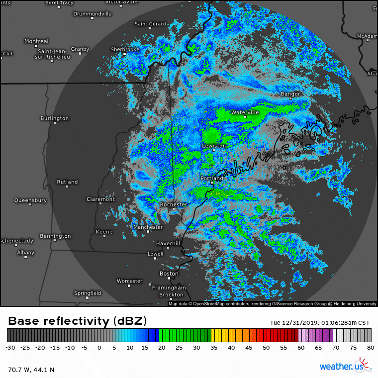
Radar imagery this morning does a good job highlighting the area of steadiest/heaviest precipitation along the Maine Coast and adjacent parts o f the foothills. The mountains are experiencing a bit of a lull in precipitation currently, but heavy snow will return there in the next couple hours.

Temperatures this morning are generally in the upper 20’s across most of the region, with the immediate coastline south of route 1 along the midcoast and east of the Turnpike/295 between Brunswick and Kittery reporting temps in the mid 30’s. Warm air should have a pretty hard time making it much farther west than it is now given that the low is passing to our east, which means winds across the area are generally from the north or northeast.

Here’s the latest NWS forecast for additional snow between 6 this morning and the end of the event. There’s still lots of snow yet to fall across the mountains and northeastern foothills with an additional 6-10″ likely to fall today and tonight. I suspect the snowfall gradient will be a bit sharper along the coast than currently advertised as the coastal front keeps a relatively sharp rain/snow line. Given relatively cooler air aloft, not too much in the way of sleet or freezing rain is expected though a brief period of mix is possible along the I-95 corridor where the coastal front might be a bit farther west at 2,000-4,000 feet than it is at the surface.

Rain, snow, and mixed precip will taper off this evening from SW to NE as the storm moves away. Temps will generally stay close to where they are now, in the mid 20’s for the mountains, upper 20’s for the foothills and most of the coastal plain, and mid/upper 30’s for the shoreline.

I’d like to end this post with a brief acknowledgement that yesterday’s forecast turned out absolutely terribly. Low level dry air was expected to halt the advance of precipitation around the NH/ME border, and given the dry air and lack of mid level dynamics, the precipitation that did fall was expected to be relatively light. Instead, a narrow band of heavy snow developed from Central NH to Cumberland County ME and dumped over 6″ of snow, when not more than 2-4″ was expected. I apologize for any inconvenience this error caused. I’ll take a closer retrospective look at this event when the dust (and snow) settles in a couple days and will publish my findings here.

-Jack

First Round Of Our Complex Storm Arrives Today

Hello everyone!

Today will feature the arrival of the first part of the complex storm system that will be impacting the region between now and New Year’s. The center of the storm is currently located over eastern Michigan and is moving north-northwest. Because the storm is located so far to our west and a very strong area of high pressure is anchored over Quebec, precipitation will have a hard time advancing through the region today.

Morning radar imagery shows steady precipitation confined to southern and western parts of the area, with the exception of SW NH where dry air aloft has already moved in. Snow is falling across most of Maine and north-central NH with the brighter echoes over south-central NH indicating the presence of warm air aloft, and thus mixing with sleet/freezing rain.

Forecast guidance for later this morning shows a similar setup to what we’re seeing now. Cold, dry air will continue moving in from Canada on north-northeasterly winds which means precipitation will struggle to make much northeasterly progress. If it’s currently snowing where you are, you’re likely to see snow for much of the day today with accumulations of 2-4″. If you’re northeast of a Brunswick-Bethel line and are currently dry, you’ll likely stay mostly dry today with little more than flurries.

Farther southwest in NH, freezing rain and freezing drizzle are being reported. Ice will continue to accumulate today with total accretion amounts between a quarter and a third of an inch.

High temps today will range from 20 in the north to 30 along the coastline.

The storm’s second act will arrive with heavy snow tomorrow morning.

-Jack

Complex Storm Approaches Today

Hello everyone!

A complex storm system will begin approaching the region from the west today, though it will be in no rush to get here. As a result, expect clouds to increase today while any precipitation evaporates before it can hit the ground. Filtered sunshine during the morning hours will help push temps back above seasonal averages before a reinforcing shot of cold air arrives tonight. Expect highs to range from around 30 in the north to around 40 in SE NH.

Some snow/sleet is possible late this evening (after 9 PM) in SW NH but overall, dry weather is expected. I’ll take a more in-depth look at the storm in tomorrow’s update as precipitation will start to fall in the SW half of the region tomorrow morning before spreading NE tomorrow night.

-Jack

Skies Slowly Clear Today

Hello everyone!

Mostly cloudy skies this morning will slowly give way to more sunshine as we move into this afternoon thanks to the arrival of a cooler and drier airmass from Canada. That new airmass will be arriving on NW breezes which will keep the mountains the cloudiest due to upslope flow. Those breezes aren’t expected to be all that strong which means it’ll take a while for the colder air to make its way over the Appalachians. With that in mind, another day of relatively mild weather is expected. High temps will range from 30 in the north to a little above 40 along the coastal plain.

Our next storm system will slowly arrive from the west beginning tomorrow, though it will take until late Monday night for snow to begin falling north or east of Portland. I’ll have more information on that system in subsequent updates.

-Jack

Light Mixed Precip Today

Hello everyone!

Today will feature light mixed precipitation as a weak cold front moves through the region. Radar imagery this morning shows a band of steady but light precipitation moving through northern and northeastern parts of the area as of 8:45 AM with a bit more still off to our west. Temps along the coastal plain are above freezing this morning, which means that plain rain is falling. Farther inland, temps at the surface are below freezing which means a mix of sleet and freezing rain is expected. While no significant ice accretion is anticipated, it only takes a thin glaze on untreated surfaces to make them quite slippery!

Precip will taper off as the front passes this afternoon. A few breaks in the overcast are possible across NH before sunset but otherwise expect mostly cloudy skies region-wide. Highs will range from 35 in the north to 45 along the southern coast.

-Jack

Clouds Increase Again Today

Hello everyone!

After a mix of sun and clouds yesterday, we’ll see a return to mostly cloudy skies today as our next storm system begins its approach from the west. This system’s precipitation won’t arrive until very early tomorrow morning, and will fall in the form of freezing rain inland/plain rain along the coast. No significant accumulations are expected, though untreated surfaces will be slippery away from the coast by tomorrow’s morning commute.

High temps today will remain a bit warmer than normal, ranging from 25 in the mountains to 40 along the NH/MA border.

-Jack

Calm Weather Continues Today

Hello everyone, and Merry Christmas to those celebrating!

Today will feature continued calm weather as high pressure slowly drifts overhead. A weak disturbance aloft will bring a layer of high clouds into the region from the west this morning, but there will be periodic breaks in the overcast especially later in the day over northeastern parts of the area. High temps will continue to be a bit warmer than normal, ranging from around 30 in the mountains to around 40 in southern NH.

-Jack

Cold Air Returns Today

Hello everyone, and merry Christmas Eve for those celebrating!

Today will feature the return of colder air behind a cold front that passed through the region last night. This process of cold air advection will involve breezy NW winds, some cloud cover over the mountains, and clear skies along the coast. It will take some time for the colder air to trek in from Canada, so more mild temps can be expected especially along the coast. Highs will range from 25 in the north to around 40 in southern NH.

Alas, no snow is expected before tomorrow morning.

-Jack

Quite Warm Today

Hello everyone!

Today will feature anomalously warm temperatures for this time of year as we move into the warm sector of low pressure system Scrooge (name not official, but it should be) located just east of James Bay in Quebec. Very warm air aloft will quickly mix to the surface on light WSW winds, and temps will soar as a result. Look for highs ranging from around 40 in the north to around 55 in southern NH. Morning cloud cover over northeastern parts of the area should quickly depart over the next few hours, leaving mostly clear skies for the rest of the day.

-Jack

Still Generally Calm Today

Hello everyone!

Today will feature continued calm weather as we remain far from the prevailing storm track currently located over the southern US. A weak disturbance will cross the area this morning, and will be similar to yesterday’s system in that there will be plenty of clouds but no precipitation. The best chance for some breaks of sun this afternoon will be found over SW NH. As a result, SW NH is also where the highest temperatures around 45 will be found this afternoon. Cooler temps are expected in the mountains and northeastern parts of the area with highs around 32.

-Jack