Today will feature mainly cloudy skies, mild temps, and the chance for showers. Showers are currently moving SE through Northern NH and into Western Maine. The midcoast is currently seeing sprinkles here and there. Showers will continue to rotate through the area today ahead of a weak cold front that is drifting in our direction. It has plenty of moisture to work with but abundant cloud cover will limit any significant destabilization and thus any real threat for strong storms though a rumble or two is certainly possible in NW areas. Highs today will range through the 70’s for most with some low 80’s possible in southern areas where a peek or two of sun is possible.
Today will feature more of the same weather wise as high pressure remains in control. Look for mainly sunny skies, warm temps, and light winds for the most part with some increasing clouds and developing sea breezes this evening. No precip is expected anywhere today. Highs will range through the 70’s for most with a few low 80’s south. Long period swells from distant Hurricane Gaston will peak today which will lead to some higher than normal surf. While that is super awesome, it will increase the risk for rip currents so be careful while enjoying the waves.
Last night’s showers panned out exactly as forecast with some strong storms entering western areas before fizzling as they moved east. The cold front that caused those storms is now just moving offshore and WNW winds will be bringing in cooler and drier air. Those WNW winds could be fairly strong at times with gusts near 30mph expected. The WNW flow will set up the classic upslope/downslope pattern with cloudier skies and the chance for a sprinkle in the mountains and sunny, dry conditions south of the mountains. The breezy offshore winds will dash any hopes of a sea breeze and thus the coast is likely to be the warmest spot today with highs in the upper 70’s to low 80’s. Everyone else will range through the 70’s with some upper 60’s possible under the clouds in the north.
A warm front has pushed through this morning and is currently moving into Northern Maine. A cold front lurks back to the west and will approach this evening. Storms will develop to our west ahead of that front and will be weakening as they head east. Far W NH may see a stray severe wind gust as storms roll through while the midcoast is likely to see a line of broken sprinkles. In between, a line of showers with an occasional rumble can be expected. The timeframe for this will be late afternoon for W NH through very early tomorrow morning (2AM or so) for the midcoast. Highs today will range mostly through the 70’s with some upper 60’s north and some low 80’s south.
We’re back to our thrilling weather pattern today with sunny skies, warm temps, and light winds. Look for a sea breeze to develop this afternoon which will lower temps along the coast but other than that, light NW winds will let temps rise into the mid 80’s for most. The aforementioned sea breeze will keep temps right around 80 along the coast and a cooler airmass will keep the northern mountains in the mid to upper 70’s.
Clouds and showers are currently entering the westernmost part of Maine this morning and they will continue to spread east this morning. Showers and an embedded rumble or two are possible as this system works through. A cold front will follow the showers, turning winds NW by early in the afternoon. Warming temps and clearing skies will be the rule for this evening and downsloping could push temps to near 90 in southern areas. Highs will range from the upper 70’s north to the low 90’s south.
HRRR Model Showing Showers Moving East This Morning, Clearing Out By Early Afternoon. Credit: Weatherbell
More tomorrow morning. With a week left until school, I won’t be doing evening updates during quiet weather as I need to shift more time and energy into homework. If you saw the mountain of summer work I have, you’d understand. I’ll still have special updates in the evenings when bad weather threatens but for the most part, I’m going to go back to morning’s only.
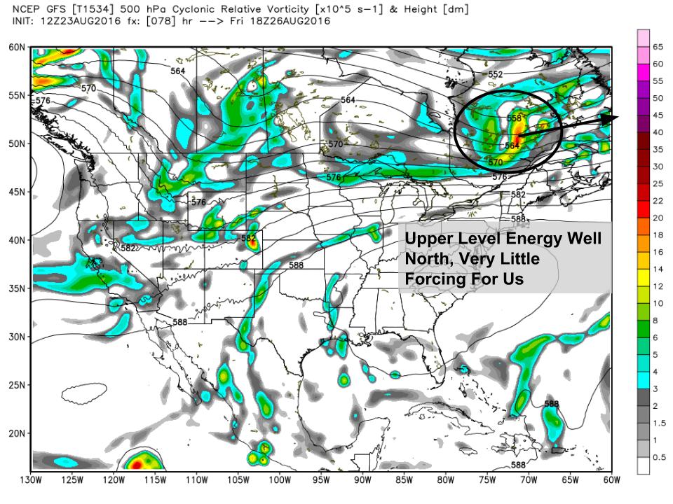
Today will feature morning sun giving way to afternoon clouds, noticeable S/SW winds, and continued warm temps. Look for highs to range from the mid 70’s north to the mid 80’s south. Skies will begin mainly sunny but clouds will work in from the west this afternoon overspreading the entire area by evening. Along with the clouds will be the chance for showers and a storm or two especially NW. The coverage of these showers will be very low but in those that do develop there could be some very heavy rain as plenty of moisture is around. The moisture won’t be the limiting factor but the trigger will be as the approaching front is quite weak and most of the upper level energy is well to our north.
A few more showers and storms are possible tonight into tomorrow morning but details remain uncertain as to just how much convection can develop upstream. My schedule this evening will probably not allow for me to do an update but tomorrow looks to be the opposite of today, starting cloudy with the chance for a shower and ending with more sun.
Today will feature slightly warmer temps and slightly higher humidity as high pressure slips offshore. Winds around high pressure move counter clockwise so as a result, we’ll be seeing warm SW winds develop as the high moves to our SE. These SW winds will increase temps roughly 5 degrees over yesterday and dew points will follow the same slow but steady increase. This means that highs will range from the mid 70’s north to the mid 80’s south with dew points remaining comfortable in the mid to upper 50’s. Winds aloft will begin to shift to the south west as well and as a result some high clouds are likely to filter in this afternoon. A spot shower is possible over the mountains but no widespread precip is likely. Other than the mountain high clouds, today will be mostly sunny.
I may not have the time to do a post this evening but know that more clouds are likely tomorrow along with scattered showers.
This week will be quiet weatherwise as high pressure remains either overhead or in close proximity. Look for slowly warming temps peaking Thursday before a weak front brings slightly cooler and drier weather for the weekend. The front will bring some scattered showers Thursday night and that’s pretty much our only chance for precip in the coming week. Another front may approach in about a week’s time but that remains uncertain.
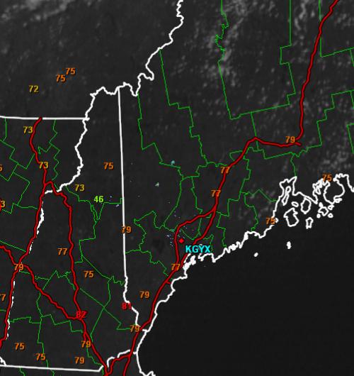
3:00 PM Observations Verifying Today’s Forecast
Today’s forecast worked out about as well as they do around here. Sunny skies ruled as expected with only a few fair weather clouds in the north. Temps stayed in between 70 and 80 and light NW breezes kept the dry air coming. I suppose no forecast is ever perfect, but today’s got pretty close! As you well know though, that’s not bound to last long and I’m sure we’ll have some more tricky weather in not too long as winter begins its slow invasion.
Our next chance for precip arrives Thursday night as a weak front drifts in our general direction. All the upper level energy associated with this storm will be to our north and all the storms therefore will be too. However, there will be that weak front which could touch off some isolated showers. These should be widely scattered with most of them located in the north, closest to the upper level energy.
12Z 4km NAM Showing An Unimpressive Setup Thursday Evening. Image Credit: Weatherbell
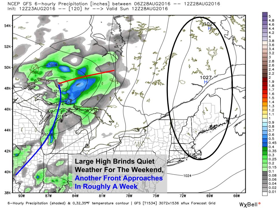
Here’s the 4km NAM with a look at what the radar could look like. Based off of the upper level pattern, I think even this looks a bit overdone as far as precip goes but notice the big storms way up in Canada with only widely scattered showers near us. This is not looking like a super impressive event by any measure. It will all clear out Friday leaving warm and dry conditions for the weekend.
12z GFS Showing Warm And Dry Conditions Next Weekend. Image Credit: Weatherbell
Not a whole lot of excitement as we head into the extended forecast. High pressure is locked in at least through early next week with, guess what, more warm and dry conditions. A weak front could approach by the middle of next week but looking at how strong the Bermuda high looks to be during that time, I wouldn’t be surprised to see that shear out to the north following in the footsteps of the front on Thursday night.
While we sit in the epitome of weather boredom here in Maine, the tropics are putting on a show with TS Gaston forecast to become a major hurricane in the next few days. It is forecast to swing way out to sea but it will send some swells in our direction. Those look to start arriving here Sunday. Surf’s up!
A pretty quiet weather day is on tap today. Look for highs in the mid 70’s north and mid 80’s south with sunny skies and light WSW breezes. A few clouds are possible across the north late in the day but otherwise, it’s all sun for everyone. There’s really not much else to say about the forecast. Enjoy the great weather!