Our recent stretch of unsettled weather will continue today as low pressure moves lethargically from the Gulf of Maine in the general direction of New Brunswick. The mountains and foothills north of the low’s center (say from a Fryeburg-Lewiston-Camden line on north) will see the steadiest rain today, but almost everyone will find themselves under a shower at some point. The best chance for rain in southern areas will be this afternoon when modest instability will try to develop in support of some more convective activity. Aside from a few rogue sunny breaks over southern NH this morning, skies will be overcast across the board. Northerly breezes and thick overcast will keep temps limited to the mid 40s up north and mid 50s elsewhere, with a few readings near 60 possible where the sun peeks out in southern NH.
Today will feature continued shower activity as another wave of low pressure develops along the frontal boundary that has been parked over the region for the past couple days. We’ll remain north of the front today, which means that temps will be right around normal and winds will be light from the east. You wouldn’t have to drive very far south, into central MA, to sample an early taste of summertime humidity this afternoon. Thankfully we have a bit longer before we have to deal with the scourge of dewpoints above 60.
Satellite imagery this morning shows overcast skies locked in place across all of New England except for parts of Maine northeast of Moosehead Lake. It is possible that the northeastern edge of the low cloud deck might slide back towards Skowhegan/Waterville over the next few hours, but thick mid/high clouds are already advancing from New York so any sunshine will be short-lived.
The radar is pretty quiet this morning, but showers will return to southern NH as early as 10-11 AM. With some elevated instability, a couple rumbles of thunder can’t entirely be ruled out though the odds of a thunderstorm are much higher in the soupy air to our south. By mid/late afternoon, rain will be advancing into central NH and southwestern ME, and by sunset, everyone will be seeing much-needed steady rain.
Steady, soaking rains will continue for much of the night with most spots picking up 1-2″ of much-needed water. With low river/stream levels and a very gradual pace of accumulation, no flooding issues are expected from this system.
High temps today will range from the upper 40s along the coastline to around 60 in the hills northeast of Augusta.
Today will feature mild temperatures and mostly cloudy skies as a stalled frontal boundary lounges overhead. Satellite imagery this morning shows some sunshine over northern and eastern parts of the area, but sadly this will be short-lived as the front attempts to slide north this afternoon. Though we will technically be on the cooler side of the boundary, there isn’t exactly a whole lot of cold air in the vicinity. As a result, temps will remain mild today with highs ranging from the low/mid 50s along the Midcoast peninsulas to the mid/upper 60s for most of the rest of the area and low/mid 70s in southwestern NH.
A wave of low pressure will ride along the boundary later in the day today, helping push clouds past their current frontier from Augusta over towards Bethel. That low pressure will also provide some much-needed rain for southern areas. Showers look to arrive in western NH around 5 PM, possibly accompanied by a few rumbles of thunder. Most of southern Maine will have to wait until sunset (7-8 PM) for rain to start falling. A few storms in southwestern NH might bring some gusty winds this evening, but I’m not expecting any major problems with severe weather at this point.
Today will feature milder weather as the storm from a few days ago weakens and slides off to our east, taking the core of the coldest air with it. Look for partly to mostly sunny skies and downsloping northwesterly breezes to lift temps into the mid to upper 60s across much of the coastal plain. With offshore flow in place, the effects of a sea breeze will be negligible so even the shorelines will get in on the warmth. Temps will rise in the mountains too with highs in the low to mid 50s.
Today will feature cooler temperatures and breezy conditions as low pressure strengthens to our northeast and drives a Canadian airmass into the region. Satellite imagery shows the usual upslope/downslope pattern emerging with regards to cloud cover and precip this morning. Overcast skies dominate the mountains with a few snow showers while the coast enjoys partly to mostly sunny skies. Downsloping will fight the incoming cold air to a draw along the coast with highs in the low to mid 50s. Farther north, the incoming chill will hold temps in the mid 30s for much of the mountains.
Today will feature the arrival of some light rain as a storm passes off to our south. Light rain is starting to move into southern NH as I write this around 10 AM and will continue to spread northeast throughout the day. By early afternoon, it should be raining across most of the area. Rain won’t be particularly heavy, but remember the umbrella if you’re headed out this afternoon. High temps today will be on the milder side, ranging from the mid 50s along the Midcoast to around 60 in the mountains to 65 in the foothills near and northeast of Augusta.
Today will feature slightly warmer weather as winds shift from the northwest more over to the west and slacken a bit. It’ll still be breezy at times, but the core of the coldest air is now to our east. With downsloping and mostly sunny skies, the coast should warm up into the mid 50s while the mountains top out in the mid 40s. Some morning upslope flurries can’t be ruled out but generally speaking, today will be dry.
Cold air has moved into the area overnight behind the storm that brought snow and storms yesterday. Gusty NW winds are supporting upslope snow shower activity while the main storm’s banding lingers from Augusta towards Camden. As the morning goes on, patchy sunshine especially southwest of Lewiston will add just enough heat to the lower atmosphere to support a renewed surge of snow shower activity across much of the area, especially in the mountains. As temps rise above freezing along the coastal plain, snow may mix with rain especially when it’s not precipitating very heavily. Any snowfall accumulations today will be confined to the northwest-facing slopes of the higher terrain.
High temps will range from the upper 20s in the mountains to around 40 along the shorelines, though gusty NW winds will make it feel a bit cooler.
Today’s weather forecast can be summed up pretty well by saying something along the lines of “all of the above” as a strengthening storm moves overhead. Heavy snow? Check. Severe thunderstorms? Check. Sea breeze? Check. Mild late-spring temps? Check. Bitter cold winds? Check. Freezing rain and sleet? Check. Upslope snow? Check. Not sure what we’re missing at this point.
Here’s how everything should shake out today.
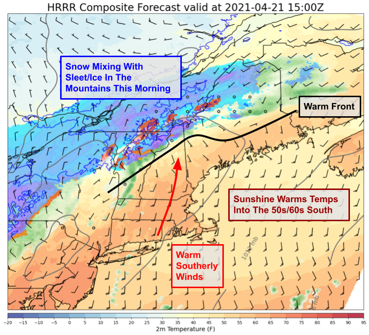
This morning, snow is falling up in the mountains and may occasionally mix with sleet and/or freezing rain. 2″ of snow has been reported so far in Rangely and another couple inches are possible especially above 2500ft. Meanwhile to the south, warm southerly breezes and bright sunshine will push temps into the 50s and 60s over the next few hours.
By midday, we’ll have built up enough instability over the foothills and coastal plain to start talking about thunderstorms.
The first round of storms looks to be developing now over the Hudson Valley and should reach New Hampshire around noon. By the time the forecast map above is valid (2 PM), storms will be entering Maine and could bring damaging winds as well as small hail and lightning. Temps will rise into the mid/upper 60s ahead of these storms in southern NH and adjacent parts of SW Maine while a sea breeze kicks in along the Midcoast and holds temps into the 50s with patchy drizzle/fog possible.
By 6 PM, the storm will be tracking right through the foothills and colder air will be on our doorstep. Snow will redevelop in the mountains and will fall heavily especially on the NW-facing slopes as winds flip around and start carrying cold air in from Canada. At the leading edge of the cold air, another round of severe thunderstorms will pose a wind/lightning threat especially in the foothills. These storms will weaken as they track into cooler and more stable air east of I-95.
No matter what type of weather you prefer, enjoy it today!