
Due to the fact that it is the holidays this update will be brief. There is a 998 low analized over NC moving to the NE. This low will continue to deepen over the next few hours. The rain/snow line will set up distinctly over coastal CT and RI this afternoon moving inland as warmer air filters in aloft. This warmer air will wilter in causing a changeover to a mix of sleet/freezing rain/snow/rain over inland CT/central MA. The warmer air wil spread out to all layers of the atmosphere over coastal CT/RI/Cape Cod/SE MA by dawn tomorrow.

Snowfall map. Red=14-18″ Darkest blue=6-10″ Darker blue=3-6″ light blue=1-3″ green=Dusting-1″
Winds will be gusty especially near the coast. NYC is under a High Wind Warning currently so be careful! Winds should peak around 45-55 mph in heavy squalls late tonight in the city.
35-45 mph a little farther away from the coast (30-40 miles) and lesser winds further away from that.
I will have a full update on the changing pattern in the next few days.
-JAck
Monthly Archives: December 2012
Christmas forecast and a look at the week ahead…
Christmas is finally almost here (3 days away!) and many of us are wondering if it will be a white christmas.
Today and Tomorrow will be cold and windy but no major problems across the northeast. The lake effect machine will be cranking today across typical areas. A few light flurries are possible across the north east today but any will be very light and will not cause any disruptions.
As we head into christmas eve, there could be some light rain/rain showers in the ohio valley but nothing major. When Santa arrives Monday night, he can expect light snow across southern New England.
There looks to be the potential for snow on Christmas day. However, activity will be light and will be focused across southern New England.

Snowfall map.
The disturbance creating this christmas snow will be weak by any standards and will skirt south of ME/NH. MA/RI/CT will see the most snow. Accumulations should be light and travel impacts will be low to none.
As we head into the middle of next week, there looks to be a stronger noreaster Wednesday night inot Thursday. Totals should be much higer with that storm yet it is too early to tell specific amounts.

Tracks of next week storms.
Cold air shoulf remain in control Thursday so it should be a predominantly snow event.
Stay tuned for more about the upcoming storms!
-Jack
Settling into a quieter next week…
Storms #1 and #2 are long gone now with #3 getting going now over the mid west. This new storm named Draco by TWC will produce blizzard conditions across the midwest with some severe weather on the south side. This storm will continue to deepen as it moves east tomorrow. Totals for Des Moines/Madison should be in the 6-12″ range with 8-14″ possible for the Green Bay area. On Friday the storm should be in the Great Lakes region bringing rain to the I-95 corridor. The ski country of Northwest ME, Northern NH, and northern VT will get more snow. Totals are approacking 3 FEET at Saddleback and Sugarloaf. Power conditions will be widespread on all the big slopes. As for the more populated areas of NYC, Boston, DC, this one will be all rain. I dont see too much to encourage snow for the I-95 corridor within the next week. There is still all of January and February and of course we cant forget March…
-Jack
Full update on winter storms
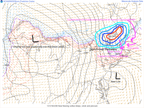
We are now on a wild roller coaster ride when it comes to the weather in the North East. A low pressure system is moving out of the Great Lakes and will be transferring its energy to a secondary low off the NJ coast.
Graphic overview of storms.
As you can see, there are many factors playing into the forecast. The coastal front, the new low, cold air damming. Cold air damming is when the heavy cold air stops the advance of Warm air. Where exactly the cold air dam sets up will play a big part in the type of precipitation. The coastal front will play an equally important part on determining precipitation types. As shown, the east winds off the warm water will bring in warmer air. This will turn snow/sleet/freezing rain into all rain. Expect this to move inland Monday-tuesday.
After the coastal front moves inland, Wednesday will already be here as will another storm. This new storm will be MUCH stronger.

This graphic depicts the setup Monday-Wednesday. The coastal front from tonight will move way inland turning everyone except the ski resorts over to plain rain. The wednesday low will move swiftly through the Gulf of Maine and into the Canadian Maritimes. On the backside of this system the cold air will make a comeback turning everyone back over to snow Wednesday evening-night. Accumulations should be light.
After we get the Monday and Wednesday storms out of the way, there will be yet another low Friday. This is a little too far out to accurately forecast so I will detail that in a later Post coming Wednesday-Thursday.
-Jack
Colder pattern next week…
As Christmas draws ever closer, Old man winter has finally gotten down to New England. It looks like there will be 2 storms systems to watch. System 1 will affect the region Sunday-Monday. There will be an area of low pressure moving into the Plains on Saturday and by Sunday, it will be centered in the Great Lakes region. This low will occlude and form a new secondary low off of the Jersey shore. This new low will then move due east passing south of Cape Cod. After mmoving east of Cape Cod, it will deepen and expand to the NW. This will spread snow bands across Coastal Maine Sunday-Monday. The storm will clear out of the region midday Monday. This is where things get interesting. The Monday storm will linger just offshore into Tuesday as another low moves up the coast. The northward moving low will absorb the monday low and will BOMB OUT. There is some question as to where the rain/snow line will set up. It looks wet across most of New England.
Stay tuned for more!
-Jack
Wintery pattern ahead…
After a week of extremely mild temps, old man winter is really hitting us with his cane later this month. Just to clarify This WILL NOT BE THE CHRISTMAS BLIZZARD OF 2010!! But there will likely be some northeast snowstorms and colder temperatures.

This image shows a “Greenland Block” setup for the 16-21 of this month. This is the setup we had in the winter of 2012-2011. This will be a major factor in bringing in the coastal storms as well as the cold air. In the 2010-2011 winter, there was also an ultral-positive PNA which is not present, an ultra strong MJO for most of January, again this year, there could be a time when everything comes together at the right place at the right time and creates a large snowstorm.
I am seeing some model development of a snowstorm in about a week from now. Stay Tuned for the latest!!!
-Jack
