
Hello everyone!
I promised I’d dust this humble blog off if there were ever a storm interesting or different enough that I felt like I could really add something useful to the conversation. With the first Hurricane Watches posted for parts of the Maine coast since 2008, this seems like as fine a time as any.
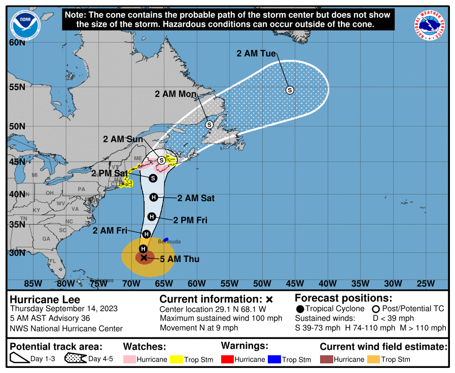
Hurricane Lee is the culprit, a sprawling swirl of storms out in the western Atlantic between Bermuda and Cuba. What the hurricane is lacking in vigorous thunderstorm action and peak windspeed, it is making up for in pure size. The Latest 5 AM EDT update from the National Hurricane Center shows hurricane force winds extending 100mi from the center with tropical storm force winds extending 290mi from the center. Hurricane Watches are posted for the Downeast coast east of Sonington with Tropical Storm Watches up for the rest of us.
I’ll start as per usual with a brief dive into the meteorology underlying the forecast before going through impacts from rain and wind to surge and swells.

Satellite imagery this morning shows Lee sitting near the base of an upper-level trough, labeled T1, currently bringing some really pleasant weather to New England (today is gonna be absolutely awesome!). Lee is about 12-24 hours too slow to interact with this trough most favorably. Instead of joining up with the warm airmass ahead of the trough and speeding northward, the storm will slowly plod through the cold airmass behind the trough tomorrow on its final approach to New England. The upshot? This is not the right setup for a true hurricane disaster in Maine or New England.
Our “great” hurricanes in New England, 1938, Donna, perhaps even Gloria or Bob, all sped north on the warm side of upper-level troughs, only spending a few hours over the cold Labrador Current that separates New England from the Gulf Stream. This fast forward motion and favorable dynamic interaction allowed these storms to make landfall without losing much of their strength due to cold waters. By the time they got here, they were only just beginning to “feel” the effects of colder water. This is just not the setup we’re looking at with Lee.
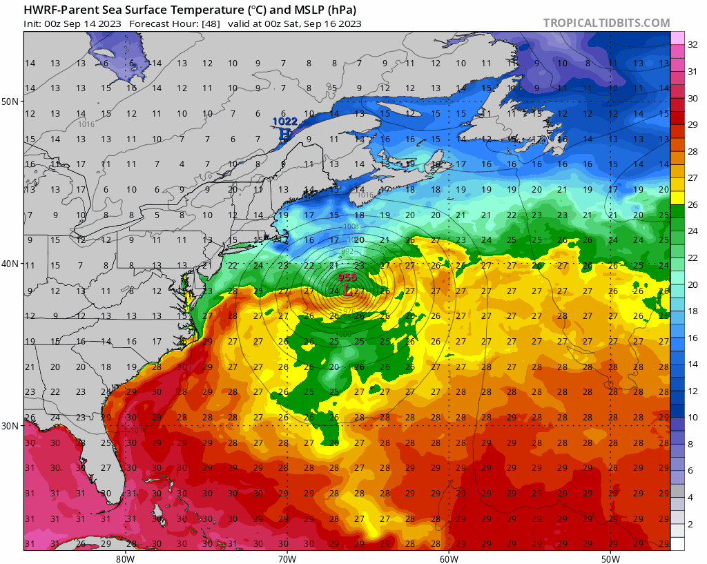
This forecast loop shows Lee (“L”) taking a full 24 hours, from 8 PM Friday to 8PM Saturday, to move from the warm Gulf Stream (yellow/orange ribbon east of Delaware) to the Maine Coast near Lubec. During that time, the storm’s powerful inner core will weaken significantly, though the storm’s larger outer wind field will remain intact.

Investigating the storm’s structure, we can see how Lee will be changing as it approaches our coast. Because the storm will be plowing straight into a cool low-level airmass as well as moving over cooler water, it will become detached from its tropical source of energy: warm water and the layer of warm air adjacent to it over the tropics. The right two panels show Lee’s v-shaped tower of heat being undercut by cool, stable air as it approaches the coast.
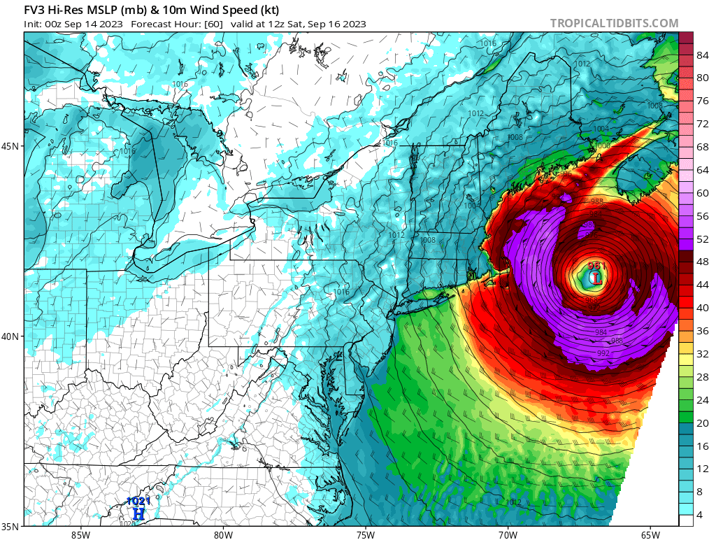
You can also see dry air impinging on the storm from the west in the bottom center panel, further helping to disrupt Lee’s core. In the top left panel, you can see an east-west cross section of Lee’s winds. Note how the east (right) side of the storm has much more wind (purple = hurricane force) at all altitudes while the right side is considerably less breezy. With the storm’s center likely tracking east of Cape Cod then up towards Lubec, that puts Nova Scotia in the crosshairs for the strongest winds rather than Maine.
What’s the point of saying all this? Some day, Maine will experience a true hurricane with impacts that will likely be dire and outside what anyone alive today has been through. This weekend will not be that day. The atmosphere just isn’t set up right to deliver a knockout blow.
So what is expected?
Today and tomorrow will be dry with a northwesterly breeze today shifting around to the north-northeast and picking up a bit tomorrow as some clouds spill north ahead of the storm. Saturday morning will dawn overcast with a stiff north breeze 20-25mph inland and 25-35mph at the coast.
Most of our area should be seeing steady moderate to heavy rain on Saturday morning depending on the storm’s exact track (the CT Valley/western NH may remain drier). The north wind on our side of the storm will help protect us from major storm surge action, though the National Hurricane Center shows a 10% chance of seeing a 1-3ft surge which could cause some minor issues with Saturday’s midday high tide.

With such a strong northerly (offshore) wind, I suspect most parts of the Maine coast will see a negative storm surge, where tides are lower than usual as the wind pushes water back into the ocean. This is especially true later in the day on Saturday after the north wind has gotten a chance to move more water south to compensate for all the extra water Lee will be bringing into the Gulf of Maine on its eastern flank and with its very low barometric pressure. Either way, this is not the right setup for a significant storm surge event in Maine. That will be more of a concern over in Nova Scotia especially along the southern coast.
While storm surge is not expected to be a significant issue, the one impact that will be truly unusual is the wave action.

Lee has had all week to build up a tremendous amount of wave energy and a good portion of that will be focused in the Gulf of Maine on Saturday. Although the absolute maximum waves will be over in Nova Scotia, this setup will easily support 12-18 foot seas in near-shore open water along the Maine coast. Breaking waves could add another 10 feet or more depending on localized bathymetric factors. Thus Saturday will be a day to stay out of and off the water unless you’re in a very protected harbor. Even if you’re standing on dry land near an exposed surf break, keep an extra eye on the ocean as rogue waves much higher than most can occur at any time and could potentially pose a risk if you’re caught off guard.
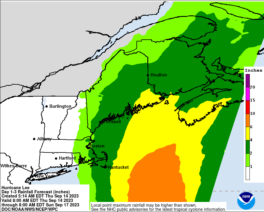
Rainfall will be in the 2-4″ range across much of Maine outside the Lakes region and mountains west of Rangely. After our seriously soggy summer, this will be enough to cause minor issues in poorly drained areas and perhaps some basements so make sure those sump pumps are in good working order especially along the midcoast. That said, I’m not expecting any widespread river flooding from Lee. Almost all of this rain falls during the day Saturday.

Peak winds will hit on Saturday afternoon in the 25-35 mph range inland and 35-50 mph range along the coast. This is quite common for our area during the winter, but it will “feel” more significant this time around because all the trees still have all their leaves. Thus I am expecting some power outages especially east of the turnpike. Winds will generally die down Saturday night.

Lee will slowly spin itself out over the Canadian Maritimes on Sunday leaving sunny skies and a gentle westerly breeze for any cleanup efforts that might be needed.
Overall, I’m thinking of Lee as a pretty moderate to higher end Nor’easter with the potential for some more power outages than you might expect given that trees are still in full leaf. It’s nothing our area can’t handle, but it’s worth spending some time today and/or tomorrow getting ready for outages along the coast. That said, outside of the maritime impacts (especially the waves), this is nothing we haven’t seen before and nothing we can’t handle even if it is unusual to have an official name and advisories issued by the National Hurricane Center.
Enjoy the storm, everyone. Until the next one,
Jack
