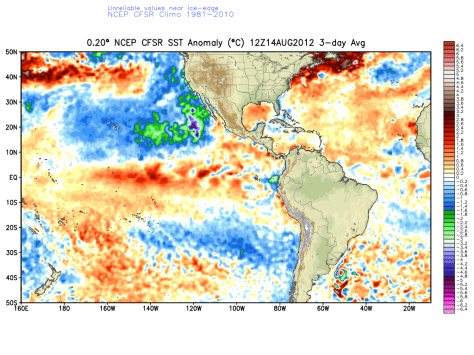
So new climate models came out today and here is what to look for for the eastern CONUS.
Winter 2012: Average for most areas. Slightly warmer with slightly more precipitation due to a Modiki type event. This is when there are above average SSTs in the equatorial East Pacific. Then comes the ice-cold Chilean current; underwater. The warm water heats up the air causing it to rise. Thunderstorms form in an area known as the ITCZ or Inter tropical convergence zone where opposing trade winds meet. These thunder storms cause an upwelling of water therefore bringing the cold chilean-current waters up to the surface. causing pools of warm water and cool water to swirl together. So in determining the ENSO (El Nino/Southern oscillation) event of this year because it is taken from averages ( cold + warm in average terms cancels to 0 there fore not El Nino (Warmer) or La Nina (Colder) but instead a modiki year which is very rare) becomes very difficult. Instead there is a different set of rules for a Modiki year.
Photo: current SSTs in the east pacific. Notice the bright reds and swirling pockets of blues.
Forecast: SNOWY and average temps For us on the east coast.
***SPECIAL WEATHER BULLETIN***
Issued for Coastal VA and surrounding areas
Valid from 200PM EDT – 800PM EDT AUG 15 2012
Severe weather will impact this region today with high winds and large hail. Be prepared for oncoming severe storms.

