After days and days of model diversion, some agreements are being reached. The one big agreement is that there will be a strong low moving up the north east coast. A classic Noreaster enchanced with extra gulf moisture and another “clipper” system as well.
Now lets dig deeper. There is currently a disturbance in the Gulf Of Mexico (GOM) that is producing heavy rains in TX/LA currently.
Map of disturbance in GOM.
This disturbance will move NE over FL and emerge of the carolinas tomorrow. Tomorrow night things really get going with the low moing NNE towards the famed 40, 70 benchmark. This is a point on the map we meterologists look at a lot to determine the effects of a storm. Anyway, as the low approaches this location SE of Boston, it will stall out for about 6 hours while absorbing the northern low pressure and rapidly intensifying. The result will be insane snow bands Friday afternoon/night. There will be a minor break in the action some time friday evening however, another push of snow on the back side of this system will drop more snow Saturday and with high winds, blizzard conditions are likely.
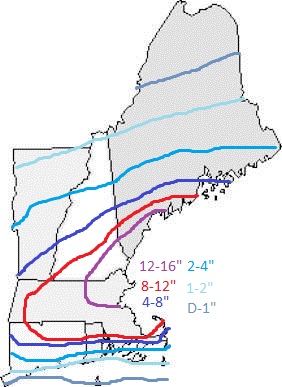
Snow map for Friday/Saturday storm.
For everyone wondering about the snow day potential here in ME, its really on the line. Friday morning will be pretty much clear as far as I can see but the afternoon gets tricky. Most likely early dismissal. Stay tuned for tomorrow nights update!
-JAck SIllin
We are heading into a more active weather pattern with two snow events and one rain event. Here I will break them down day by day.
The first one will be a small system that will be a moisture starved clipper system bringing under 2″ of snow for most of the area.
Here is a snow map for the clipper system.
The next system is the more interesting one. There will be two clipper systems moving across the country on thursday. There will also be 2 jet streams that will direct these storms and feul them with energy and moisture from the Pacific. The southern storm, moving over the energy laden Gulf of Mexico will rapidly develop while moving NE off the south east US coast. This low will absorb the northern low giving it an extra boost of energy. Cyclogenisis will occur off of Cape Cod as the low slows down. The european model has the pressure at 974mb while the GFS likes a more moderate 988mb solution. I am leaning with the “jack” model also known as a compromise right down the middle. I am thinking a 980mb low moving slightly SE of an area known to meterologists as the “benchmark” or 40N 70W. For us, this means that there is a potential for significant snow across the region.
Early snow map for Friday storm.
Note: this map will continue to be refined throughout the coming days and is only an early guess for now.
The third and final storm in the forseeable future will impact us early next week. This event will be assosiated with a low moving to our west putting us on the warm, rainy side of the system. Temps in the 40’s along with rain will melt any snow that falls on Friday.
I will try to update the blog every day as new forecasts become avalible regarding the friday system.
-Jack
Sadly, I do not see any big snow in our future. I do however see some light snow on sunday as a low passes well offshore. But first, let me get to today and saturday. Both days will be quiet weather wise. Today will feature slightly more of a westerly wind but nothing like yesterday. By saturday winds will of calmed down more. Both days feature sunny skies with a few fair weather clouds. Today there is a slight chance for a flurry or snow shower but the potential is small. Temperatures will be chilly with highs in the 20’s with lows getting down into the single digits.
-Jack