Overnight, much happened in the tropical Atlantic. Our disturbance 97L consolidated it’s multi-centered low level structure into 1 main low level circulation (LLC). However, it lost most of it’s convection. We also have 2 more invests and one more AOI on top of that.
By the numbers:
3 invests (97L, 98L, and 99E)
1 AOI
1 TD (KIKO)
2 day probability of formation into TD/5 day probability of formation into a TD (in%)
97L: NHC 20/50
ME 30/50
98L: NHC 10/20
ME 20/30
99E: NHC 20/80
ME 30/80
AOI 1: NHC 10/30
ME 0/20
KIKO: 35 mph 1005mb

Atlantic tropical weather outlook.

Eastern Pacific tropical weather outlook.
—————————————————————————————————-
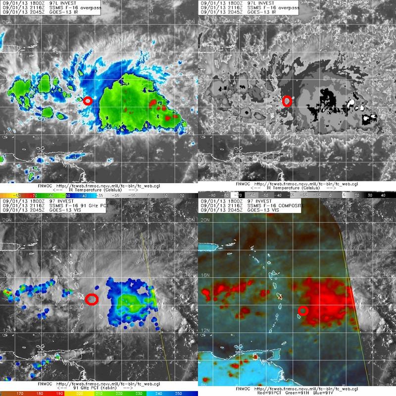
97L
Overnight the diurnal minimum, the time of day when the sun’s energy is the least really took its toll on 97L. The storm lost most of its heavy thunderstorm activity as shown by satellite imagery.

This image shows 97L and a new tropical wave that has been moving across the Atlantic for the past few days. 97L has been moving very, very slowly over the past day or so and this new wave is now overtaking it. What this will do is bring much needed moisture and lift to the storm which will likely enhance thunderstorm activity. Notice the burst of convection near Barbados. This is near where the LLC is located. This is a sign the storm is strengthening. However, it still has a long way to go before it attains TD or TS status.

In this graphic, I’ve highlighted the LLC and the new tropical wave approaching the system. Notice that the majority of the convection on this map is associated with the new tropical wave. This tropical wave will likely reinvigorate 97L with more moisture and atmospheric lift which helps to create thunderstorm updrafts.

This map shows how little 97L has in the way of thunderstorms and how much energy the new wave might put into 97L. It also shows indications of a healthy outflow pattern. You can tell because of the wispy looking clouds to the north of the center. This shows that cool, dry air is being vented out of the storm which is important for development.

In this graphic I’ve highlighted the center in black and the approaching tropical wave in red. Notice how in the top 2 images the area near the center looks like it contains healthy thunderstorms. Now look at the bottom 2 and notice how that area is devoid of any real convection. What you’re seeing in the top 2 images is just cirrus clouds left over from old convection.
The forecast for 97L
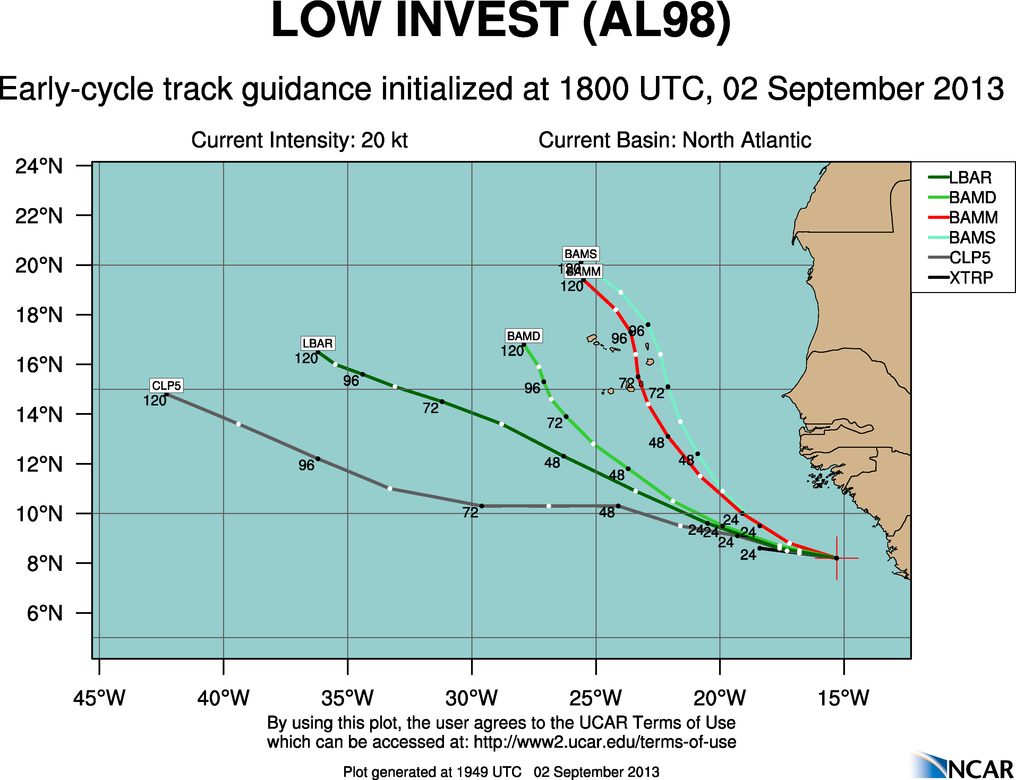
Track:

This map shows the tracks proposed by the various hurricane models.
Here’s my take:
The only way this system can go to the NW is if a trough off the east coast (responsible for the rainy Labor Day) pulls it to the north. However, for this to occur, the system must extend its circulation higher into the atmosphere. Due to the dry air present at the middle levels of the atmosphere, I don’t have confidence that it will be able to strengthen enough to get affected much by the trough. I expect it to continue on its track to the WNW and affect Hispaniola Wednesday with heavy rain being the primary threat. After that, I expect it to continue WNW over the Bahamas on Thursday. This is when development is most likely.
Intensity:

This map shows the intensity forecast proposed by the various hurricane models.
Here’s my take:
I expect that for the next 24 hours, it will be struggling to figure itself out. In a day or so, the new tropical wave will complete merging with 97L and that is when it will have more of a chance to develop. However, I do not expect development until AFTER its passage over Hispaniola if it makes one. That is because the mountainous terrain that is the dominant feature of Hispaniola acts to disrupt the circulation of tropical cyclone not to mention robbing them of their heat energy. Therefore, it is when the storm is in the Bahamas late this week and into next weekend that development should occur. However, IF the storm takes a track due west which is also a possibility, then development should occur around 72 hours out when it is over the Western Caribbean. If this were to be the case, I would expect that it would reach weak TS strength before hitting the Yucatan. If it enters the Bay of Campeche, a strong TS is possible.
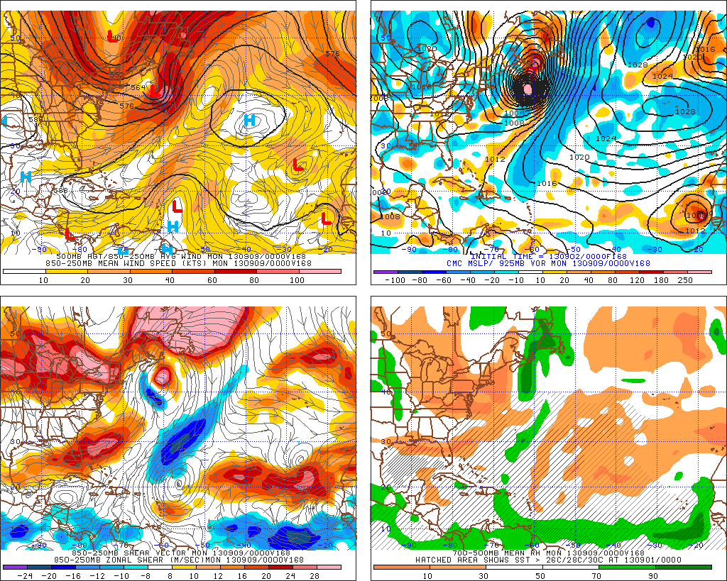
One funny thing I found while looking at the models was this

This is the CMC model forecast for 168 hours out (7 days). It shows 97L as a powerful extra-tropical cyclone. It then goes on to slam Canada. Do not worry however, this scenario is HIGHLY unlikely to happen. It just goes to show how models can not always be fully relied upon and that sometimes, they just entertain us weather geeks more that anything else.
98L
A tropical wave moved off the coast of Africa yesterday and overnight it has acquired a sufficient amount of convection for it to be designated 98L by the NHC.

This is a satellite image of 98L. Notice how much more thunderstorm activity it has vs 97L.

This graphic shows the center in black and a developing spiral band in red. This could be important in aiding the development of this system as these spiral bands tend to act as a conveyor belt bringing warm moist air into the storm from afar. Notice the wispy cirrus clouds to the NW of the center this indicates a healthy outflow pattern which will also aid in development.
The forecast for 98L
Track:

This map shows what the models think of the track of 98L. Notice that since 98L is much better organized than 97L, models forecast a sharper northward turn.
My take:
I think 98L will develop fairly quickly resulting in a tug northward. It may affect the Cape Verde islands with rain and wind in the upcoming days as it tracks near or over the islands. It’s a much more straightforward forecast here thankfully and there are not many scenarios to talk about.
Intensity:

This map shows what the models have to say about the intensity of 98L.
My take:
I think that the models are spot on here. I expect to see development within the next 48 hours with the system reaching weak TS strength by 72 or 84 hours out. After that, the system will move over cooler waters and dissipate. NOt much variation in outcomes here either.
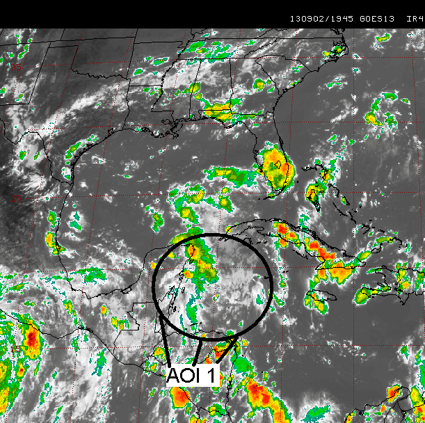
AOI 1
This system is not an invest yet so the amount of data is limited. There is a tropical wave off of the southern Yucatan peninsula that has started to fire up some convection today. However, development will be little to none in the next 48 hours.

This map shows AOI 1, a disorganized tropical wave with little chance of development in the next couple of days. Where we have to watch it is when it moves into the Bay of Campeche. This area is notorious for spinning up tropical cyclones rather quickly because of the topography of the area.
The forecast for AOI 1
Given this storm does not have invest classification yet, the hurricane models are not able to weigh in on the forecast. But I will look at the regular models and outline what they have to say below.
GFS: Open wave heading due westward.
CMC: open wave heading due westward.
NAVGEM: Stationary TD in the Bay of Campeche.
My take: I am going towards the GFS/CMC scenario. I just dont see any factors going for it. It’s poorly organized and I highly doubt it will be able to develop into anything.
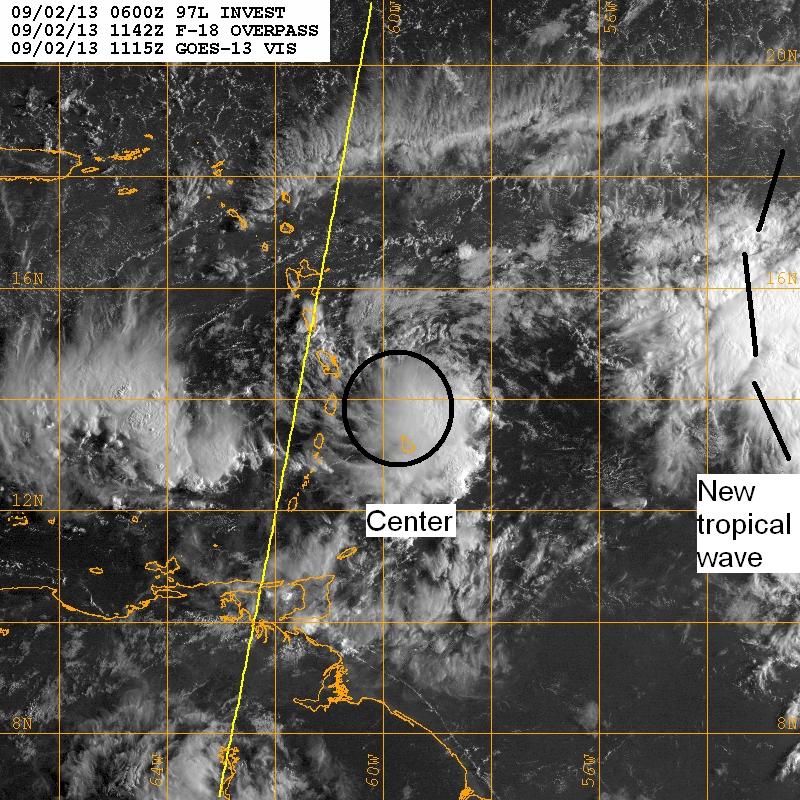
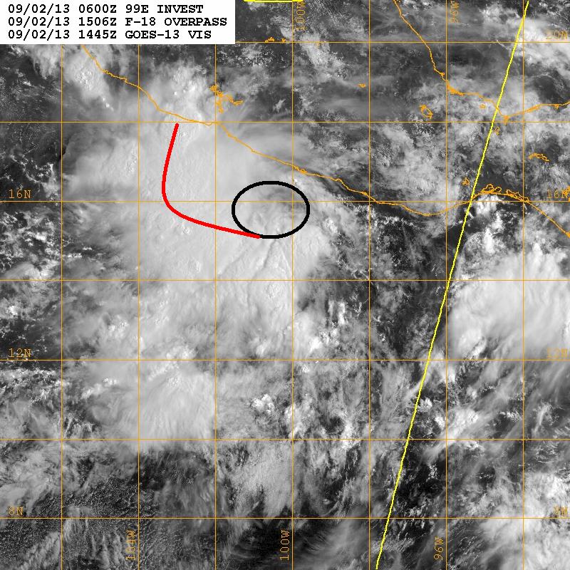
99E
There is a tropical wave off of Central America in the Eastern Pacific ocean. It has plenty of convection and will not have too much of a problem developing in the next few days.

This is a satellite image that shows the abundance of convection associated with 99E. As I said, It has little to worry about in terms of development.

In this graphic, I’ve highlighted the center in black and a developing spiral band in red. The storm has good outflow channels in all directions and plenty of convection which is well organized. Now all it has to do is organize an LLC and it will become the 12th depression of the Eastern Pacific hurricane season.
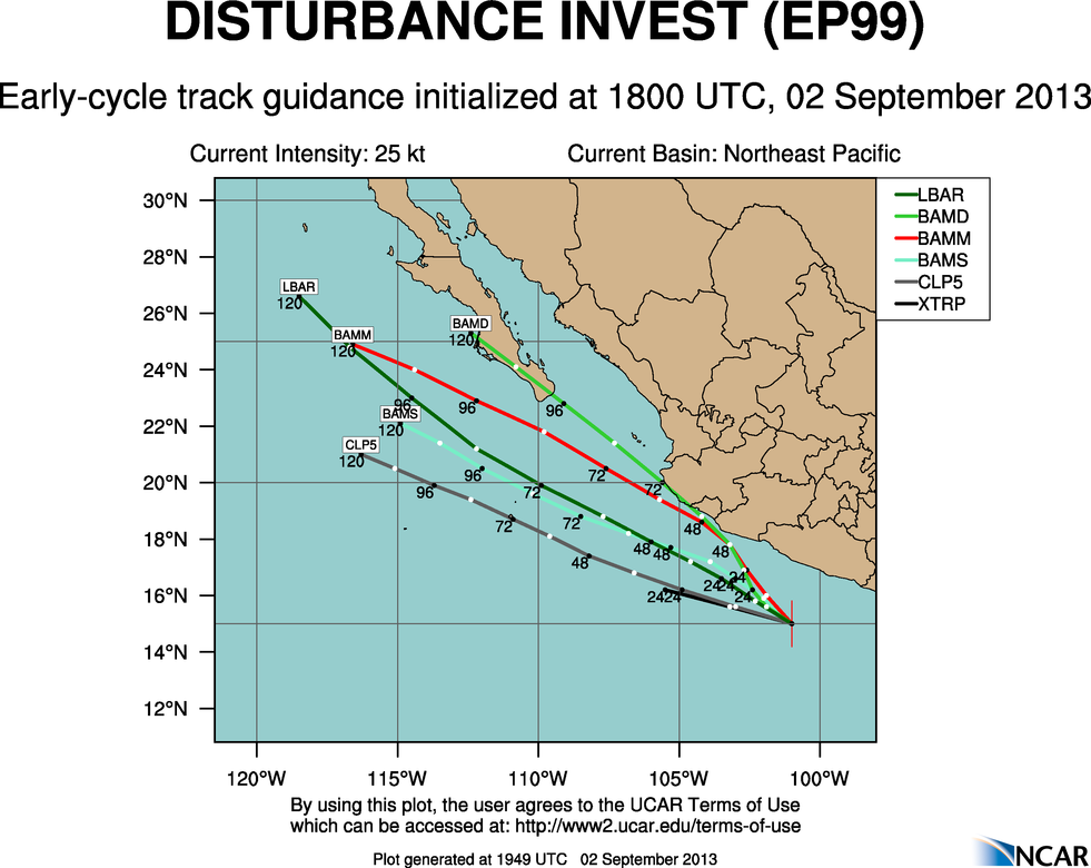
The forecast for 99E
Track:

This map shows what the hurricane models think of the storm’s track.
My take
I think that the hurricane models have it nailed here. Monsoonal flow that is bringing flooding to the Southwestern US will likely suck 99E to the north like it did to KIKO a few days ago. I expect the only impacts on land will be widespread rain across northwestern Mexico and the southwestern US.
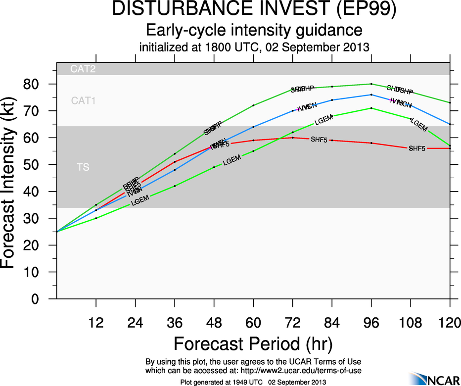
Intensity:

This map shows what the hurricane models think of the intensity of 99E in the coming days.
My take
I expect the models to be a slight bit conservative here. I think a strong CAT 1 is certainly possible here. This area has spawned some very intense tropical cyclones over the years and the disturbance is very well organized.
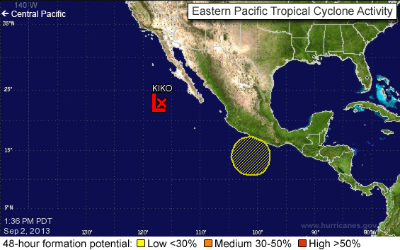
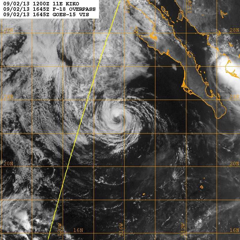
KIKO
Tropical depression KIKO is dying and in another couple of hours will be nothing more than a low level swirl. Therefore, there is not much to say about KIKO.

Tropical depression KIKO in the Eastern Pacific.
In other weather news…
A cold front is moving through the eastern US bringing heavy rains to the region. Expect clearing tomorrow afternoon. Until then, beware of flooding as this system has a lot of moisture associated with it.
In the western Pacific tropical storm TORAJI is expected to hit Japan in a few days bringing heavy rains and high winds to the country.

This map shows the expected track and intensity of TORAJI.
Next update will be in the next 2 days.
-Jack