
Hello everyone!
Today will be the calm before the storm in our area as high pressure hangs on. Expect a chilly start around 0 but temps rebound into the 20’s this afternoon under full sun. Winds will be light out of the SE.
Our storm will arrive tomorrow morning around 11 with snow quickly becoming heavy. Sleet may mix in along coastal York county and the mid coast but otherwise we stay all snow. The afternoon commute Thursday will be a messy one with several inches on the ground and snow falling heavily.
I expect the worst of the storm to be just before/after dark Thursday with heavy snow, high winds, and low visibilities. Snow continues Thursday night ending around 9 or 10 Friday morning. Snow from another system starts up Friday night into Saturday.
As for totals, highest amounts should be in the foothills where a fluffier snow will cause things to pile up more quickly. My snow map is below.
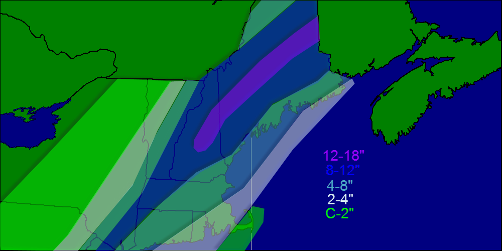
Temps will be running in the low 30’s for the duration of the event so expect a heavy wet snow that will be hard to shovel/plow. This type of snow also tends to weigh down trees and power lines so that in addition to high winds will cause a few power outages here and there although I expect no major problems regarding outages.
Coastal flooding is always something to watch with these storms, however tides are astronomically low right now so only minor beach erosion/splash over is expected.
It looks like we have more snow in the forecast for Saturday and a mixed bag of precip should arrive Tuesday.
-Jack
