Snow today

Hello everyone!

Today will feature a cloudy start ahead of our next storm. Clouds will spread northward as the day goes on and snow will not be far behind.

Snow will overspread southern New Hampshire this morning between 7 and 8 and will move into southern Maine between 8 and 9. Snow will become heavy after noon and thunder could accompany the heaviest bands with snowfall rates approaching 3″/hr.

Snow will taper off this evening into tonight SW to NE as the low pulls away. Any leftover snow will end by 1-2 am. Expect winds to kick up once again as the low deepens.

As for amounts, expect a wide swath of 4-8″ across Southern Maine and New Hampshire while coastal New Hampshire and Massachusetts will have to deal with a mix/rain line holding down accumulations.

Snow map 2-18


Snow map.

More snow arrives tomorrow mixing with sleet/freezing rain along the coast. A warm up is expected late week with rain plaguing the area Friday. Do not fear fellow winter lovers! The cold returns Sunday and lasts as far as the eye can see.

-Jack

Cold today, snow returns tomorrow

Hello everyone!

Today will feature chilly temps with chillier wind chills. Highs will top out in the 10’s inland and the 20’s at the coast. Winds will be in the 10-15 mph range with gusts occasionally topping 25 mph. This will result in wind chills at or below 0.

High pressure remains in control of our weather for one more day resulting in mostly sunny skies for the majority of today. Some high clouds may affect western regions ahead of our next storm.

Our next storm arrives tomorrow with some snow. The snow then becomes heavy as the storm rapidly intensifies off Cape Cod. Most of the 6-8″ expected will fall in about 6 hours however confidence is still low regarding when the 6 hours of snow will occur.

Wednesday will be another day of clearing out except snow should start up again late afternoon changing to an icy mix as warm air moves in aloft. This will be associated with a warm front lifting northward. After the front passes, southerly winds will bring in very warm temps with highs topping out in the 40’s.

-Jack

Quiet today and tomorrow

Hello everyone!

Today will feature a quiet day for a change in terms of weather. High pressure is over the area which will cause sunny skies to prevail. Temps will be comfy, in the 20’s, however there will be a fly in the ointment so to speak. This will be the winds behind our ‘storm’. WNW winds will gust as high as 25mph causing the freshly fallen snow to blow around a little bit.

Our ‘storm’ last night was a bit of a dud because it tracked farther east than expected. We got about 1.5″ here in Yarmouth while areas in Eastern  Mass got over a foot.

For those who love snow (myself included!), keep in mind that this almost works to our advantage in that all this snow over the Mid Atlantic and Southern New England will protect us from any big warm up. As the warm air mass heads north this week, 2 things will happen. First, it may not even get to us in Northern New England as warm fronts are notoriously hard to get through a deep deep dish snow pack. Also, if/when it does get here it will have been travelling over hundreds upon hundreds of miles of snow. This will cause it to “modify” or become less warm.

Tomorrow looks to be a lot like today except without the wind. Our next chance for snow looks to be Tuesday with 1-3″ expected.

-Jack

Another storm on the way

Hello everyone!

Today will feature another winter storm approaching with clouds building as the day goes on. Expect to see at least a little sun this morning but things cloud over reasonably quickly.

Temps will be in the mid 30’s today at the coast while in the upper 20’s inland.

Snow looks to move in from the west in association with the clipper system that will spawn our coastal low. Towns like Fryeburg, Bethel, and Bridgton can expect snow to start in the early afternoon. Snow here will be light as the clipper system will be the main driver rather than the coastal low.

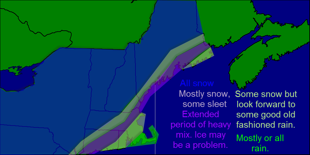
Towns along the coast get the snow mid afternoon as the coastal low starts to get going. Expect snow to become moderate in the late afternoon hours as the coastal low moves NE. Snow becomes heavy overnight especially along the coast.

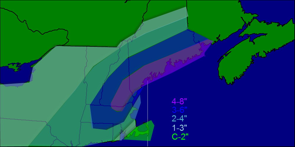
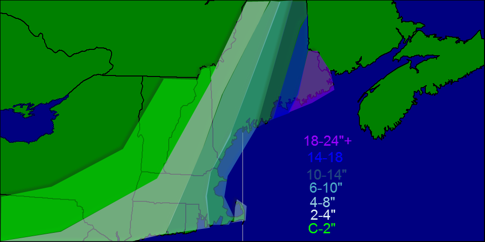
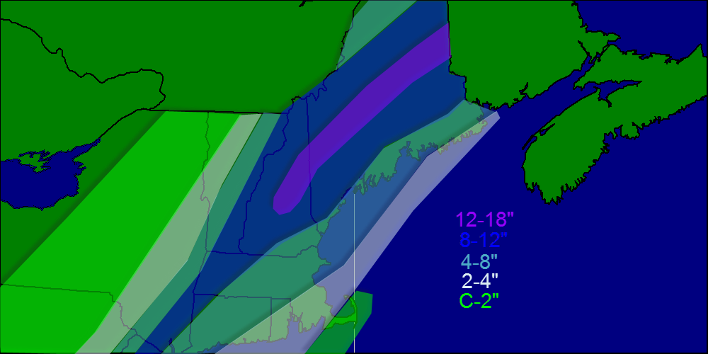
Regarding amounts, due to the fact that this storm is moving so fast, expect totals to increase the farther east you go. As of now, 6-10″ is a safe bet for Portland and Augusta with amounts likely toward the 6″ part of the scale. Upwards of 2 FEET is expected over Downeast Maine.

Snow map 2-15

Winds will be cranking with this storm as it rapidly intensifies. Expect sustained winds to reach 20 mph at the coast with gusts well into the 30 mph range. This will cause blizzard conditions up and down the coast as the light fluffy snow will blow and drift easily. Expect blizzard conditions to move in around 9 and continue through Sunday morning.

Impact map


Here is where I expect blizzard conditions. Even if we don’t meet the visibility/wind/time criteria for an official blizzard, it sure will look and feel a lot like one. For inland areas, especially in Southern Maine, winds should be a tad too low and snowfall not as heavy so blizzard conditions are unlikely in those areas.

Snow will wind down Sunday morning as the low pulls away into the Maritimes. Expect lingering up slope snows in the mountains while the Midcoast and eastern Maine still get snow from the main system.

It appears we have more snow in the forecast for Tuesday followed by a dreaded thaw and rain late next week. Don’t worry fellow lovers of winter! The 8-14 day outlook gives us hope as march looks to come in like a lion with a cold and stormy pattern to start the month.

-Jack

Snow comes to an end today, returns tomorrow

Hello everyone!

Today will be devoted to digging out as our storm is now about 25 miles off of Portland with a pressure of 978 mb. Snow continues on the backside of the storm up in the Mountains where the ski resorts are getting a solid dumping of POWDAH!

After getting about 6″ down my walkway with the shovel, it promptly snapped in half signaling a very heavy, wet snow with a nice layer of ice on top. I advise anyone who has to shovel to do it now before more snow falls on top of it later on today.

Wintry mix should change to all snow as the storm pulls away and the heavy band over the mountains pivots south and east. Expect another dusting to maybe 2″ through this afternoon.

Temps will be falling from near freezing to the lower 20’s as the day goes on. Gusty NW winds will make it feel even colder as the storm intensifies while moving NE.

We may see some partial clearing before out next storm moves in tomorrow. The models are taking this storm farther and farther West with every passing run so I’m leaning towards a solid 2-4″ for most areas with 3-6″ along the coast. I expect no issues whatsoever with mixing as this storm will be much colder.

Keep in mind that if the track shifts west, we could be looking at another major storm and if it shifts east, we see nothing but a dusting. Confidence is high in my mind that we will get at the very least an advisory criteria event (2″+).

-Jack

Mid-storm update: heavy snow continues

Hello everyone!

Our storm is intensifying nicely down off the Mid Atlantic and we are certainly feeling its impacts here in Maine. Heavy snow bands are moving through the area with snow rates approaching 3″/hr in some locations with 1-2″/hr rates more common. At my location in Yarmouth, we have 6.5″ on the ground as of 5:45 and it continues to come down hard. Winds are picking up as well with many locations now reporting gusts up to 25 mph.

Conditions will continue to deteriorate over the next few hours as the storm strengthens and winds intensify. Blowing and drifting snow will become an issue as well as the evening progresses.

Confidence continues to be low as to where the mix line will set up but the storm is slightly east of the forecasted track, so the mix line may set up farther east than expected.

Temps will rise from the 20’s to the low 30’s as warm air moves in aloft and gets pushed down to the surface by heavy precipitation. Expect the snow to turn from dry and fluffy to heavy and wet as temps warm.

We may see a brief lull or break in the action in the next few hours as a dry slot tries to work its way into the area however its progress has slowed significantly so we may not have to worry about that.

Overall, I still have confidence in my snow map from this morning although amounts may be a hint low at the coast especially Downeast Maine but the change to mix should occur there shortly.

Snow map 2-13


Here is the snowfall map from this morning. I still have confidence in this map so no changes were made.

I’ll be back again tomorrow morning with the normal daily forecast as well as an update on a possible snow event Saturday. As of now, that looks to be minor however some models have shown a more robust solution. More on that tomorrow.

-Jack

Nor’easter to bring snow/ice to the region

Hello everyone!

The main weather story today into tomorrow will be a powerful area of low pressure that will be intensifying off the coast. This will bring heavy precipitation to the region causing slick roads and messy commutes. I expect snow to start around 10 am here in Cumberland County with a start time closer to 7 or 8 for York county and later as you head NE. It will not take long after the first flakes fall for the snow to become heavy as the storm is bringing an incredible amount of moisture up the coast. With all this moisture, comes warm air and that will cause problems with mixing along the coast. Right now, the storm is slightly east of the models so expect mixing to be confined to the very immediate coastline. Coastal York, Sagadahoc, Knox, Waldo, Hancock, and Washington counties stand the best chance for mixing. Expect a period of sleet and freezing rain between 10 pm and 3 am for all areas while Downeast sections get to look forward to some plain old rain during about that time.

Ptype 2-13


Here is what to expect regarding precipitation type.

As for snowfall amounts, most places can expect between 8 and 12″ of heavy wet snow as temps for most people will be in the low 30’s, while the mountains will receive 14-18″ if dry fluffy snow, what us skiers call POWDAH!

Snow map 2-13


Snowfall map for today into tomorrow.

Expect snow to be heaviest this afternoon into tonight with snowfall rates approaching 2″/hr. Snow winds down Friday morning between 10 and 11 as low pressure slides east.

Winds will be a problem as well, as our storm will have roughly the same pressure as a category 2 hurricane. Also, this storm will be much closer to shore than normal nor’easters so the highest winds will be much closer to the coast. Expect winds sustained near 20 mph with gusts approaching 40 mph especially near the coast.

I’ll have another update mid-storm this afternoon.

-Jack

The calm before the storm

Hello everyone!

Today will be the calm before the storm in our area as high pressure hangs on. Expect a chilly start around 0 but temps rebound into the 20’s this afternoon under full sun. Winds will be light out of the SE.

Our storm will arrive tomorrow morning around 11 with snow quickly becoming heavy. Sleet may mix in along coastal York county and the mid coast but otherwise we stay all snow. The afternoon commute Thursday will be a messy one with several inches on the ground and snow falling heavily.

I expect the worst of the storm to be just before/after dark Thursday with heavy snow, high winds, and low visibilities. Snow continues Thursday night ending around 9 or 10 Friday morning. Snow from another system starts up Friday night into Saturday.

As for totals, highest amounts should be in the foothills where a fluffier snow will cause things to pile up more quickly. My snow map is below.

Snow map 2-12


Temps will be running in the low 30’s for the duration of the event so expect a heavy wet snow that will be hard to shovel/plow. This type of snow also tends to weigh down trees and power lines so that in addition to high winds will cause  a few power outages here and there although I expect no major problems regarding outages.

Coastal flooding is always something to watch with these storms, however tides are astronomically low right now so only minor beach erosion/splash over is expected.

It looks like we have more snow in the forecast for Saturday and a mixed bag of precip should arrive Tuesday.

-Jack

Cold this morning, snow arrives Thursday

Hello everyone!

Today will feature a very chilly start with temps below zero for all locations in Maine and New Hampshire. Winds today will be light as we are sitting under one of the ingredients for our storm, a high pressure system. This high pressure system will shift east and act as a block to prevent the storm from going out to sea. As of now it looks like light snow develops late morning Thursday and becomes heavier Thursday afternoon possibly mixing with sleet or freezing rain. By nightfall, everyone is all snow and the snow will be very heavy with snowfall rates exceeding 2-3″/hour. Winds will also become very gusty out of the NE at 30-40 mph. Snow continues into Friday morning winding down towards lunchtime. Again, we are still 2 days away so lots could change but that is my current idea of what will play out. I will wait until the 10am models to make any accumulation predictions. As for snowday predictions, too early to say but it looks good for erly dismissal Thursday and snowday OR delay Friday.

-Jack

‘Surprise’ snow ends this morning, cool and quiet through midweek

Hello everyone!

This morning we were greeted with some ‘surprise’ snowfall as an inverted trough has lingered a tad longer than expected. Total accumulations should be in the 3-4″ range with isolated 5-6″ amounts. Snowfall should taper off this morning ending between 9 and 10 am. Temps today will make it only into the 20’s as a WNW wind picks up behind the system. The beginning of the week looks to be cool and quiet as high pressure dominates. This high pressure will shift east Wednesday which could set the stage for a storm Thursday.

-Jack