
Hello everyone!
Today will feature the passage of a strong cold front bringing in cooler temps this afternoon and much colder temps for tomorrow. Highs get into the low 30’s at the coast and mid to upper 20’s inland.
Tomorrow will feature extreme cold for this time of year with lows near 0 and highs struggling to get to 30. Tuesday will be more of the same although by them the air mass will have moderated slightly.
Wednesday features the possibility for a major storm. There are 3 different scenarios that I will break down below.
Scenario 1: Storm goes E out to sea giving Cape Cod and SE MA heavy snow but nothing here in Maine. Eastern CT and Eastern Mass would also get some snow. Likelihood of happening: 20%

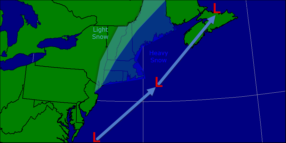
Scenario 2: Storm comes closer to the coast but does not hug the coast. Coastal areas would see heavier snow while inland areas would see light snow. Likelihood of happening: 50%

Scenario 3: Up the coast over or just barely east of the benchmark resulting in a major storm for the area. Heavy snow falls over much of the area and high winds become a problem as well. Likelihood of happening: 30%
In a few hours, new models will become available with much more accurate info. I will have another update this afternoon if anything changes with this storm. I will be continually breaking down updates on twitter @Jacksillin.
Late week features a warming trend and also some wet weather. Highs will reach the 40’s with rain falling. Flooding may be an issue as inland areas have close to a foot of water locked up in snow. Coastal areas have 3-6″ of liquid in the snow pack. When this is released, there could be flooding especially in areas with ice jams left over from the January thaw.
This storm this week could be the pattern-breaker meaning this wintry pattern goes out in a spectacular display of power before being broken down. Think of the storm January 1-2 before the weeks long thaw. That is a perfect example of a pattern buster. Only time will tell when winter’s spell will break, but this could be it.
-Jack
