Mild and breezy for the first day of spring

Hello everyone!

Today will feature mostly sunny skies and mild conditions as temps rise into the 40’s along the coast and 30’s inland. Breezy west winds will be the only issue today gusting over 20 mph at times.

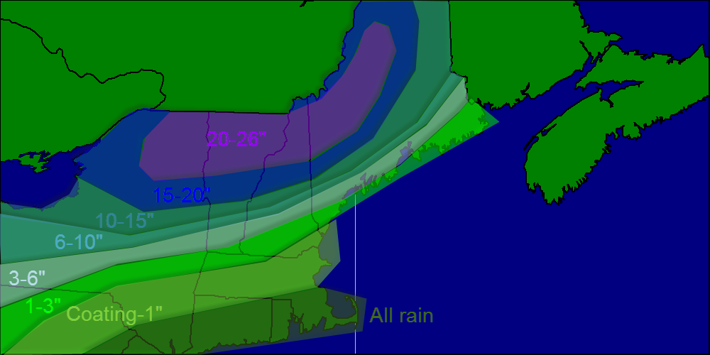
Tomorrow our next storm moves in spreading snow across inland areas and snow, sleet, and rain at the coast. While amounts likely will not reach the 12-16″ reported in some areas yesterday, it will be similar to yesterday’s setup.

Sunday features a return to below normal temps in the morning and then an intense cold front bringing in a very, very cold air mass for early next week. Highs will not get above 30 Monday or Tuesday and lows will be near 0.

That will set the stage for our next potential storm mid next week. Right now, I am leaning towards a glancing blow with several inches along the coast. That can an will change as this is a low confidence event. Follow me on twitter @JackSillin for more constant updates. I may post an afternoon update here if necessary.

-Jack

Un-springy welcome to the new season

Hello everyone!

Today will feature the arrival of the spring season at 12:57 PM. Here in Maine, the town of Waterford received 12″ of new snow. Madison NH picked up a whopping 13.5″. In Yarmouth, we got 1.5″ as well as some sleet, freezing rain and rain.

The rest of today will feature continued snow inland and continues rain at the coast. Highs inland will rise into the low 30’s and highs at the coast will jump into the mid 40’s! A stiff east wind will also make it feel raw this morning.

The passage of the front or “fropa” will occur at around 11 this morning. After this time, expect a few sunny breaks as well as a drier west wind and an end to precip.

While the calendar says it’s spring, Mother Nature has no such thoughts for the next 2-3 weeks. Look for more snow Saturday accumulating 1-3″ and more on Sunday accumulating less than an inch.

Sunday will also feature the passage of a strong cold front which will drop temps a good 10-15 degrees to start the week. Monday morning will be a cold one with lows in the double digits below 0.

Our next chance for a big storm arrives in the middle of next week. Unlike our weekend events, confidence is very low on this one but it looks like at the very least, the coast gets brushed with several inches.

While it is still far out, and there is still lots of uncertainty, the pattern is ripe for a big storm to form and ride up the coast. We have a fresh invasion of arctic air coming in and basic meteorology says to look for storms on the leading edge.

-Jack

Sunny but cool today

Hello everyone!

Today will feature full sun for most of the day with the exception being later in the afternoon when some high cirrus clouds will filter in from the west. Temps will be cool but not cold with highs in the low 30’s not unlike Yesterday.

Tomorrow will feature a spring-like welcome to the new season with a cold rain, temps in the 40’s and a stiff east wind. Snow, sleet, freezing rain, and rain move in Saturday and we’re back in the icebox Next week with the chance for a larger storm midweek.

-Jack

Cold and clear today

Hello everyone!

Today will feature cool and clear conditions as high pressure remains in control of the weather. Today will also feature the first sea breeze of the year with inland towns getting up into the mid 30’s while the coast remains cooler with temps around 30.

Looking ahead, we have a spring-like welcome to the first official calender day of spring with rain and 40’s ushering in the new season Thursday. Thursday also marks the day when we gain the most daylight.

Winter makes a comeback with snow in the forecast Saturday and more arctic air for next week.

-Jack

Cold and breezy today

Hello everyone!

Today has brought an end to a wonderful spring break for me so I will have an update here every day as usual at the usual time between 6 and 7 am.

Today will feature some high clouds from a strong storm affecting the DC region. As of 3:30 am, DC received 6″ of snow and it has been snowing hard since then. Snow will continue down there through mid-morning.

Another, more noticeable effect of the storm will be northerly winds. These winds will make for a chilly day with highs in the 20’s but wind chills starting at 10 below this morning and rising to near zero midday.

Looking ahead, we have snow/sleet/freezing rain Wednesday followed by rain and temps near 50 Thursday. Warm weather stays until Saturday when an arctic front ushers in more Maine-like spring weather for early next week. Expect highs Sunday into Monday to be in the 10’s and 20’s.

-Jack

Quiet few days ahead

Hello everyone!

We finally have no large storms in the forecast as high pressure takes control. I’m sorry to say however, this is a cold high pressure and temps do not make it above 32 for more than a day or two.

There are 2 minor flies in the ointment so to speak. One arrives tomorrow and another mid to late week next week. Neither will bring accumulating snow for many and neither will bring major impacts. Both however will deliver precip in the form of sleet and freezing rain with some snow mixed in.

For tomorrow, expect some showery mixed precip in the south and some light snow in the north and mountains. Snow in the mountains will accumulate 1-3″.

-Jack

Winter storm moves out today

Hello everyone!

Today will feature the tail end of our latest winter storm which will bring more snow, and lots more wind. Winds will gust to 40 mph along the coast and 30 inland and this will cause hefty blowing and drifting. Snow will continue into the late morning hours accumulating an additional 1-3″.

-Jack

Winter storm bearing down on the region

Hello everyone!

Today will feature a mixed bag of precip depending on location. The immediate coast will see rain while the coastal plain will see freezing rain and sleet and the mountains all snow.

Expect precip to start within the next 2 hours and become steady as the day goes on. Heavy precip arrives tonight. Expect things to wind down tomorrow morning as the storm pulls away.

Just a few tweaks to the accumulations map, models were a tad cool yesterday so adjusted totals down a tad at the coast. Also pulled the trigger on 2 feet+ for the mountains as high QPF and higher ratios will make for a heck of a storm up there.

Snow map 3-12


Snow map

I’m off skiing today so if anything changes I’ll have one last update tonight.

-Jack

The calm before the storm

Hello everyone!

Today will feature a temporary return to spring with temps rising into the 40’s under sunny skies. As a result, much of the 1-2″ of snow that fell last night will melt today. Winds again will be light out of the NW.

Looking ahead to our storm, models shifted even farther north last night resulting in a warmer solution. This means that the foothills will likely see a period of freezing rain and sleet with ice accumulations of up to 1/4″. Coastal areas will see a period of plain rain.

However, the 6z GFS, something that I usually don’t pay attention to, has moved the storm farther to the south which would result in a cooler solution like the Euro has had all along. This will be something to watch around noon today when the 12z models become available.

With regards to snowfall, ski country will love this storm with the ski areas getting up to 2 feet. Areas along the coast will see anywhere from 1-3″ on the tips of the Peninsulas and the islands, to up to 4 or 5″ in the interior parts of the bays.

Snow map 3-11


Snow map

With regards to timing, expect precip to arrive midday Wednesday in the form of snow. Warm air invades Wednesday evening turning precip to sleet, then freezing rain and then rain for coastal areas.

Ice accumulations will reach 1/4″ across the foothills where freezing rain will prevail the longest. This, combined with the heavy wet snow falling across these areas and the strong winds coming from the deepening low, could cause power outages.

Everything changes back to snow Thursday morning accumulating several inches along the coast. During this time, any water left over from rain/snowmelt will freeze so watch for slippery surfaces.

Cool temps briefly after the storm on Friday followed by a warm up over the weekend and then another cool down early next week.

-Jack

Winter storm to blast the area mid-week

Hello everyone!

This morning at around 7 am, our storm made landfall so to speak on the west coast and at 8 am, dozen of weather balloons monitored its every move. Huge super computers all around the world crunched the numbers and at around 11, we weather geeks got to see the results.

The general consensus was a tad farther north with the low. What this means, is that we now have to worry about mixing with or changing to sleet or maybe even rain along coastal York and Cumberland counties.

Another implication of the shift north is that the axis of the heaviest precipitation shifts farther north into our area. This means that southern areas will see extremely heavy precip Wednesday night. Northern areas will see a steadier precip with no dry slot implications. Northern areas will also see all snow.

Winds will also be an issue if the storm tracks farther north as we will be closer to the center of the storm as well as the strongest winds. Winds will gust over 30 mph at times which could cause blizzard conditions. Blizzard may be overused in this event but it sure will look like one Wednesday night.

For a storm to be officially a blizzard, winds must be 35 mph+ and blowing or falling snow must cause visibilities to fall below 1/4 mile. All of this must occur for 3 hours straight.

With regards to amounts, a solid 10-16″ can be expected with amounts close to 20 inches across ski country and 8 or 9″ amounts over far southern York County. I will have a snow map out tomorrow.

-Jack