I do have internet so I will post updates today and tomorrow.
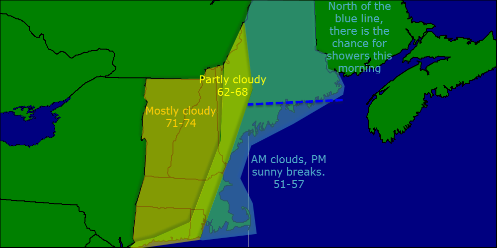
Today will feature a cool day especially towards the coast. The isotherms (lines that connect areas with equal temperature) will be running almost north/south as warm air surges north to our west while the warm air has not quite reached our area. Highs will be in the 70’s west, 60’s in the middle, and 50’s east.
Used MAV/MET/MOS for temps, SAT/NAM, GFS blend for clouds and radar for precip.
If you are like me and thought yesterday was much too hot, relief is here. A backdoor cold front passed through last night and as a result, temps are 20-25 degrees cooler than yesterday. Highs today will make it into the 50’s at the coast and 60’s inland.
I may not be able to update the blog tomorrow or Thursday so in case I can’t make it to a computer, here is the forecast.
Tomorrow: Clouds move in in the morning, mostly cloudy with highs in the 60’s to near 70 over SNE. No precip is expected as the front hangs across SNE.
Thursday:
Warm and humid ahead of the cold front. Highs in the 70’s to near 80 for SNE. Humidity will also be high so it will feel a lot warmer than it actually is. Some diurnal (Daytime heading driven) showers are possible but they will be few and far between.
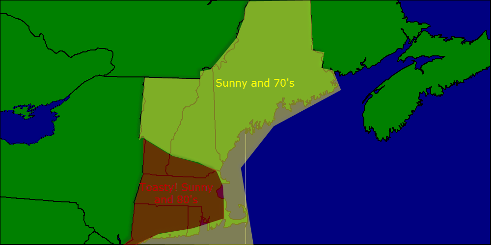
Today will feature warm temps and a nice breeze just like yesterday. Highs will again be in the 70’s in NNE and in the low 80’s in SNE. Skies will be mostly sunny as we sit in the lull between storms. Winds will be out of the west so expect little in the way of a sea breeze.
Used MAV/MET temps corrected for marine influence (Coastal SNE won’t make it to 80 but coastal NNE will have no problem making it to 70). NAM/GFS/SAT used for clouds/lack therof.
The week will start out with warm temps and sunny skies much like today. Highs will be in the 70’s in NNE with 80’s in SNE. Winds will be westerly meaning the effects of s sea breeze will be mitigated.
The mid week period looks cool and wet with an onshore wind bringing cool moist air in from the water. Periods of rain, fog, and drizzle are likely with highs only making it into the 50’s or 60’s.
Unsettled weather looks to continue into the late week period and maybe even into the weekend. Next week features improving weather as the upper level low responsible for this week’s rain slides offshore.
I will be away for Wednesday and Thursday this week so I will post a detailed forecast for the mid week period tomorrow but will not have updates Wednesday or Thursday mornings.
Today will feature lots of clouds with the chance for an afternoon shower or storm. Highs will be in the 50’s as a SE breeze will keep the marine air firmly in place even inland. Tomorrow will be more of the same but Mothers day continues to look fantastic with sun and temps in the low to mid 70’s.
Used NAM/GFS/HRRR/ARW blend for precip/storm potential. MAV/MET was used for temps more weight on MAV temp profiles as they seemed more reasonable given the current situation.
Today will feature nearly the same conditions as yesterday with sun and temps in the 60’s north and 70’s south. Clouds and showers are possible in Southern New England but NNE looks to stay dry and mainly cloudless as high pressure eats away at the approaching front.
Used SAT/NAM for clouds, MAV/MET for temps, pretty straightforward forecast like yesterday.
Today will feature sunny skies and temps in the 60’s in Northern New England and 70’s in Southern New England. Winds will be light and all in all it will be a great day weather-wise. More of the same tomorrow but clouds increase along with showers Friday and Saturday. Sunday clears out with temps in the 70’s!
Used general model blend for temps. SAT for clouds. Pretty straight-forward forecast today.
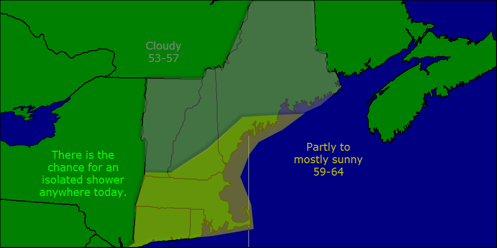
Today will feature partly to mostly sunny skies with the chance for an afternoon sprinkle. The morning will start off grey for Casco Bay and points West as there is one band of clouds sitting over us unfortunate souls but it will move out in the next hour or two. There is the chance for an isolated sprinkle but consider it to be just a sprinkle- no big deal. Highs will be in the 50’s north to the 60’s south.
Used MAV/MET blend for temps and SAT OBS/NAM for clouds. Model consensus was used for precip.
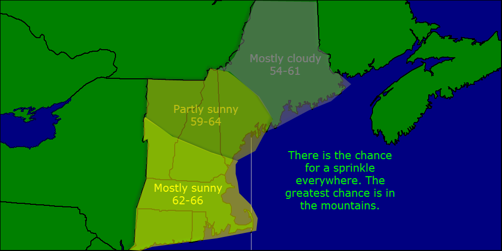
Today will feature predominantly good weather with partly cloudy skies and light NW winds. Temps will rise into the mid 50’s north and low 60’s south. The one hiccup will be the chance for another popup shower this afternoon. There is less of a chance of small hail but don’t be surprised if a little ice falls in some of the larger showers.
The week will start out nice with mostly sunny skies and the chance for an afternoon shower. Highs will be in the upper 50’s. Mid week will be the best part of the week with highs in the low 60’s and lots of sun. More rain Thursday before a return to sun Friday. Enjoy the week!