Hello everyone!
Winter storm warnings and winter weather advisories are flying for large parts of the area this evening ahead of a majorly disruptive pre-thanksgiving storm.
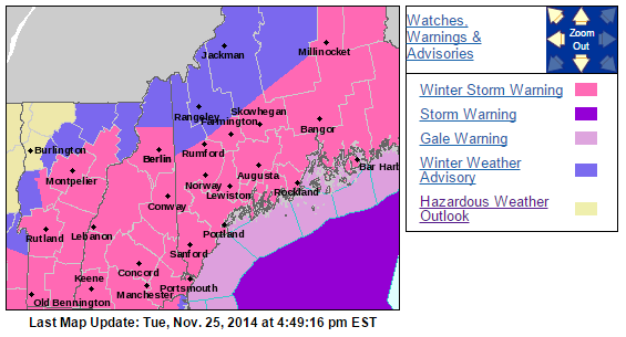
For more details please visit the NWS website.
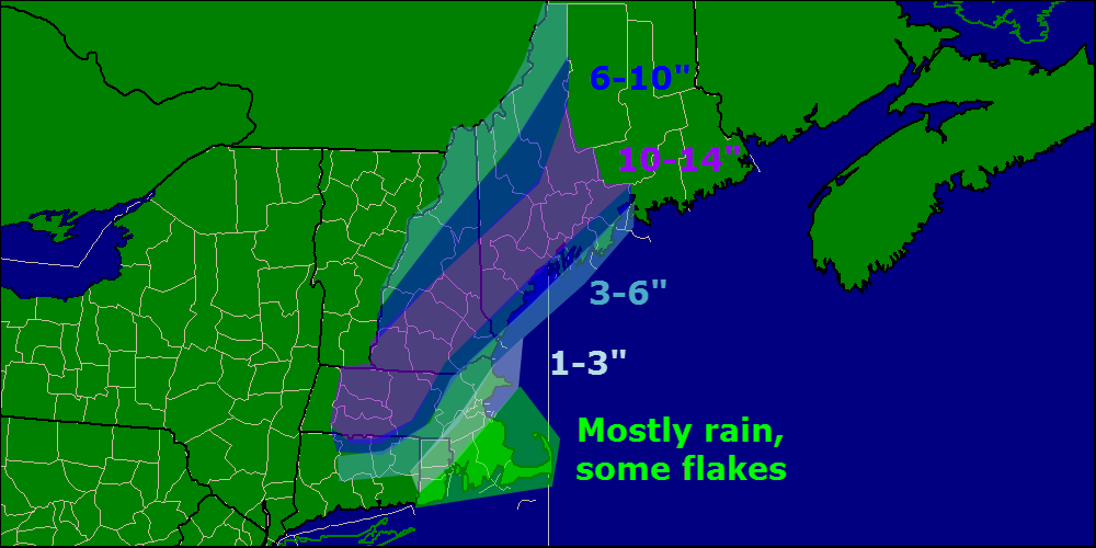
Last blog update today and we do have some important things to talk about. First off, this is a very hard forecast especially for coastal Maine. Our main problem continues to be a warm layer at roughly the 650mb level (high high up there) that will tamper with the formation of snowflakes. When temperatures are too warm at this level, snowflakes have a hard time forming. this can result in icier snowflakes, or columns as they’re called, falling from the sky. This can be a problem as far as accumulations go because these types of flakes are much harder to accumulate than normal flakes.
In addition to our snow growth problem, we have a very warm ground in place from two days in the 60’s which will make accumulations harder. Also, the event will start as a period of rain before changing over to snow which will further warm and thaw the ground. With a warm and wet ground in place to start the event, I can easily see accumulations being cut down especially at the coast. This will also be a very heavy, wet snow so we have basically an anti-fluff factor working against us. With compaction and melting, should the coast flip to rain at some point, I can easily see how you will end up with less snow on your car than you may have seen on a map. For this reason, I have trimmed back totals a little bit at the coast. I think that inland areas should have no problem with snow growth and the snow will be a tad drier there as well.
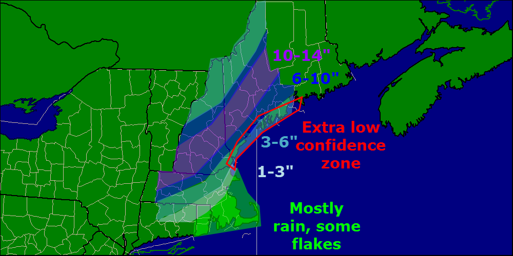
Should temps be a little chillier at 650mb or the switch to snow happen a little faster, coastal areas could pick up more snow. Should a warm layer work in aloft and the coast flips to sleet or columned snowflakes, totals go down. That is why I have highlighted coastal Maine as ‘extra low confidence’. That’s not to say I am super confident about the rest of the area, I just want to put it out there that bust potential is high.
I will be back tomorrow morning with another update. This will be a now-casting type of event so I encourage you to follow me on Twitter for the latest updates and forecast tweaks tomorrow as things unfold.
In my post earlier today, I went over the timing and impacts in great detail. I will copy and paste that below because it remains unchanged.
FROM EARLIER TODAY:
Timing:
Wednesday AM: The calm before the storm. Quiet conditions, no travel impacts. Generally cloudy across the area.
Wednesday Midday: Light snow starts in SNE and works its way north. By 1PM or so, Portland Maine should be in on the snow but not much farther north. Immediate coastal Maine will start as rain for about 10-15 minutes before wet bulbing takes over and cools things off. Once precip starts, expect mostly snow to fall. Travel impacts: Light to moderate
Wednesday PM: Precip has overtaken all of the area. Snow is falling heavily across interior SNE with rain along the coasts of RI and MA and mixing along the NH coast. Maine is pretty much all snow after this. Heavy snow bands should work their way north during this period. Travel impacts: Moderate to high.
Wednesday evening: The height of the storm. Heavy snow is falling over interior SNE with the snow line collapsing towards the coast. Maine is experiencing heavy snow as well. Mixing in NH should change to snow during this time. Cape Ann MA and SE MA remain all rain. Travel impacts: High to very high.
Wednesday night/wee hours of Thursday AM: Calming down. Heavy snow has moved into ME and all precip is ending across SNE. Rain should change over to snow for almost everyone, excluding the cape, for at least a brief time before precip ends. Travel impacts: High becoming moderate
Thursday AM: All done. Snow has moved into eastern ME but slick spots will still be around as temps will fall below freezing for everyone. Even those who saw rain could see puddles freeze up. Airports will also be clogged up with delays due to ripple effects from the storm. Travel impacts: Light (still high for airports).
Other impacts:

Winds gusting over 30mph at times will cause blowing snow and reduced visibilities especially in heavy snow bands. Watch out for harsh road conditions in any of the areas shown in Red, Orange, or Pink in the maps above. While that is just one model, I think it lines up nicely with the forecast.
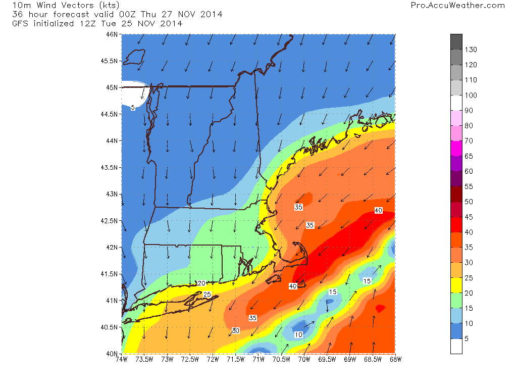
Winds will be an issue as well cranking over 30mph at times. This combined with over 6″ of heavy wet snow for lots of areas leads to an enhanced risk for power outages.
-Jack