
Hello everyone!
Busy day in the weather world today as a high-impact storm gets ready to move up the coast on the busiest travel day of the year. Below I will highlight impacts, timing, and what might go wrong and why.
All the players are on the field so to speak right now as energy is diving south across the plains (the kicker energy) and more energy is rising up through the GOM. The interaction between these two peices of energy will be key in determining where the heaviest snow sets up.

Water Vapor imagery clearly shows our developing storm system over the SE US as well as the energy diving into the plains states that will help to guide the storm up the coast.
Timing:
Wednesday AM: The calm before the storm. Quiet conditions, no travel impacts. Generally cloudy across the area.
Wednesday Midday: Light snow starts in SNE and works its way north. By 1PM or so, Portland Maine should be in on the snow but not much farther north. Immediate coastal Maine will start as rain for about 10-15 minutes before wet bulbing takes over and cools things off. Once precip starts, expect mostly snow to fall. Travel impacts: Light to moderate
Wednesday PM: Precip has overtaken all of the area. Snow is falling heavily across interior SNE with rain along the coasts of RI and MA and mixing along the NH coast. Maine is pretty much all snow after this. Heavy snow bands should work their way north during this period. Travel impacts: Moderate to high.
Wednesday evening: The height of the storm. Heavy snow is falling over interior SNE with the snow line collapsing towards the coast. Maine is experiencing heavy snow as well. Mixing in NH should change to snow during this time. Cape Ann MA and SE MA remain all rain. Travel impacts: High to very high.
Wednesday night/wee hours of Thursday AM: Calming down. Heavy snow has moved into ME and all precip is ending across SNE. Rain should change over to snow for almost everyone, excluding the cape, for at least a brief time before precip ends. Travel impacts: High becoming moderate
Thursday AM: All done. Snow has moved into eastern ME but slick spots will still be around as temps will fall below freezing for everyone. Even those who saw rain could see puddles freeze up. Airports will also be clogged up with delays due to ripple effects from the storm. Travel impacts: Light (still high for airports).
Accumulations:
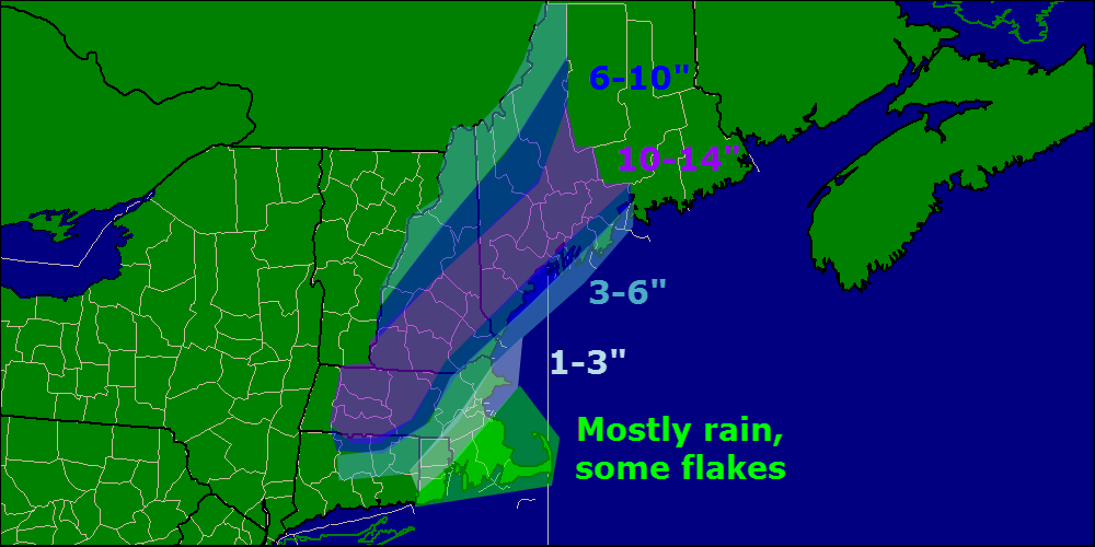
As confidence has increased regarding moisture/presence of cold air, 10-14″ zone was added. I still think midcoast Maine mixes a little bit and wetter snow overall holds down totals generally along coastal Maine. That being said, I still think that with lots of upward motion and dynamic cooling, the coast can do well in this storm.
Other impacts:

Winds gusting over 30mph at times will cause blowing snow and reduced visibilities especially in heavy snow bands. Watch out for harsh road conditions in any of the areas shown in Red, Orange, or Pink in the maps above. While that is just one model, I think it lines up nicely with the forecast.
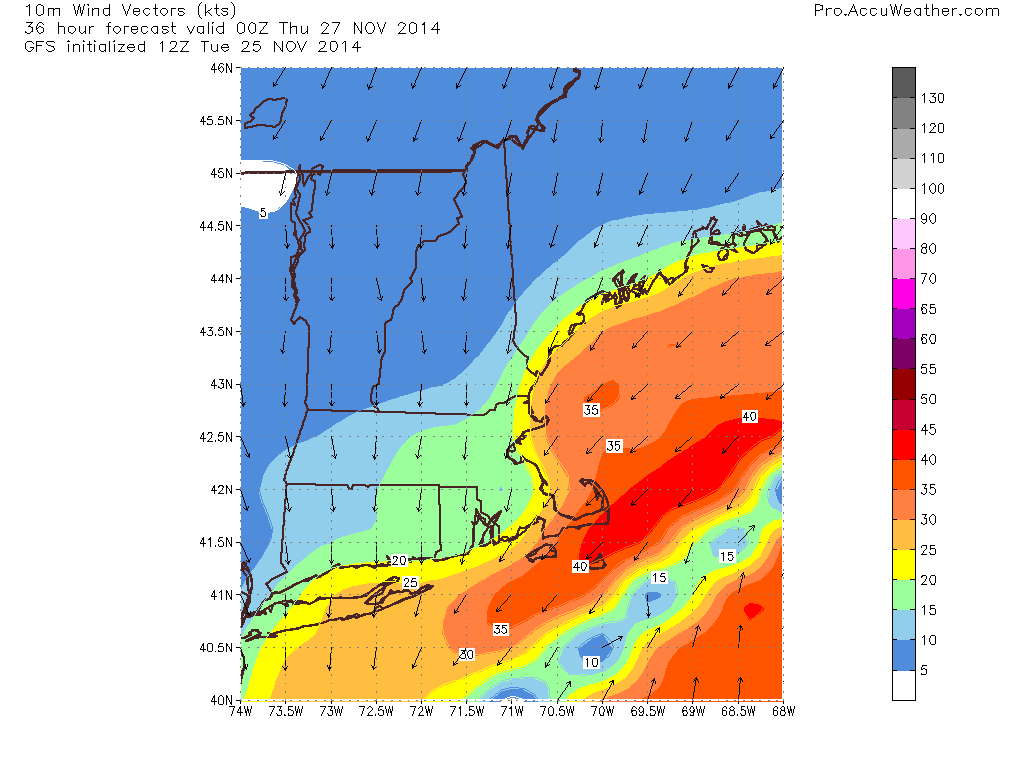
Winds will be an issue as well cranking over 30mph at times. This combined with over 6″ of heavy wet snow for lots of areas leads to an enhanced risk for power outages.
More updates on Twitter this afternoon @JackSillin and I’ll be back on here with another update this evening.
-Jack
