
Hello everyone!
Our long-awaited storm is coming to fruition this morning with heavy rain bands already impacting SE MA. Should you need to travel this morning, do it now as conditions will rapidly deteriorate this afternoon/evening.
The forecast timing is mostly intact although precip is arriving a little earlier than expected should that factor into your travel plans. Precip should start as rain for most (even the bullseye areas of Central MA are seeing rain now) but should quickly change to snow once heavier precip and dynamic cooling takes over.
One important change from last night is that models are now in almost unanimous agreement on very strong mesoscale banding developing across the region. This is largely due to a very strong strengthening of the thermal gradient with height (frontogenesis). The sensible application to this complex idea is that when you have a lot of frontogenesis, you have a lot of heavy precip.

If you want snow that is thumping away and piling up fast, this is what you want to see. Something like this indicates that very strong banding will set up over coastal Maine as well as the foothills of Maine extending down into NH. By this time, temps will be cold enough for all snow, and if for whatever reason they aren’t, this will knock them down pretty quick.
On the other hand however, the cold air has been just a hair slower than expected in moving into the region. This leads me to believe that some areas may have a slightly harder time going over to snow, especially along the coast. Due to the harder time changing over and the strong banding signals canceling out, I am inclined to leave my snow forecast intact. Keep in mind, those numbers are a range of estimates. Some areas, especially along the immediate (within a mile or two) may fall into the lower end of the scale.
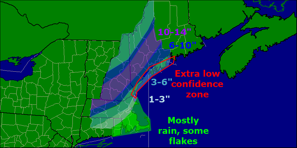
One thing I should note is the potential for higher amounts in the mountains. Models have pushed the strong frontogenesis band I talked about earlier farther north in recent runs and that could raise snow totals for the ski areas.
I will have more updates on twitter today and depending on conditions, may or may not have another update here. Next update for sure will be tomorrow morning.
-Jack
