
Hello everyone!
Today, while the weather is cold and quiet, I will take some time to look back on how I did with the forecast for our most recent storm. I will also look back on what I did well and where I went wrong and why.
The Forecast:
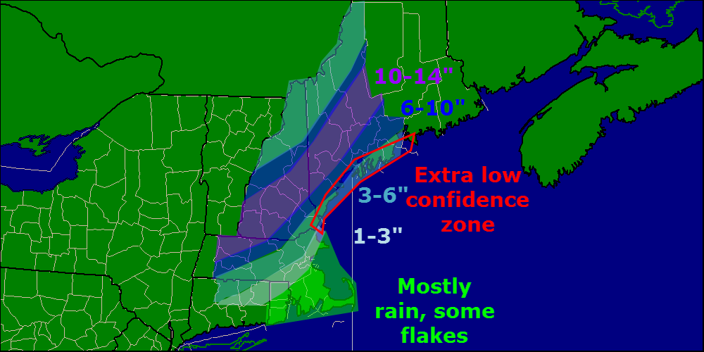
I put this map out 48 hours before the event and stuck with it all the way through.
What Actually Fell:

According to the NWS, this is what actually fell.
Region By Region:
The mixing along the coast that was forecast panned out well. Most coastal areas fell into the higher range of the 3-6″ forecast with interior Casco Bay seeing higher totals, as forecast. The only area that underperformed at the coast was Rockland where only 2″ fell. The only significant overperformers were in York county where an unexpected 12+” fell.
Overall grade for the coast: B+
Inland areas lined up very well with the forecast with most areas seeing the 10-14″ forecast. There were a few 15-16″ amounts but overall they were very isolated and most areas verified well.
Overall grade for inland areas: A
The mountains were the weakest area this storm with only some areas south of Rangely seeing the forecast 3-6″. There were widespread 6-8 and 8-10″ amounts near Jackman that were not forecast. Despite the fact that the forecast totals were not expected when just referring to the snowfall map, the discussion from Wednesday morning did note the potential for higher amounts in the mountains
“One thing I should note is the potential for higher amounts in the mountains. Models have pushed the strong frontogenesis band I talked about earlier farther north in recent runs and that could raise snow totals for the ski areas.” From Wednesday Morning’s discussion.
Overall grade for Mountain areas: B
Overall, I think the forecast was pretty good for the area. I have isolated the culprit behind the blown mountain forecast, the strong frontogenesis band that the models did show but I did not have enough confidence in to change the map. The one true area of surprise was in York county where nothing pointed to 12″+ amounts, though those did fall. Very strong banding was likely responsible for those totals although more mesoscale influences like terrain or location of measurement could also have played a part.
Overall grade for the area: A-
I’ll be back later in the day tomorrow with a look at the week ahead. Brief recap of tomorrow’s forecast: Cold and mainly clear, highs 26-34.
-Jack
