Evening update on long-duration nor’easter

Hello everyone!

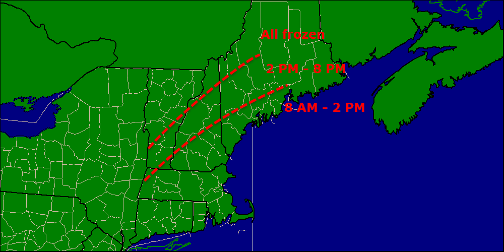
The forecast is mostly on track this afternoon as warm air continues to pour in both at the surface and aloft. We saw once again today the power of cold air and cold air damming as it took us here in Yarmouth until about 2 PM to switch from freezing rain to rain. Warm air will continue to push inland this afternoon and evening eventually making it all the way to the mountains by late tonight.

Rain snow line

Here is a snapshot of current observations across the area showing our cold wedge slowly eroding. Expect continued slippery conditions inland and in the mountains tonight.

Winds are kicking up offshore as are seas (notice the buoys on the map showing wind gusts in the 40mph range with 12-17 foot seas. Expect both of those numbers to rise as the storm strengthens near Long Island. My thoughts from this morning regarding winds remain unchanged and 50-60mph gusts are still expected at the coast with 30-40mph gusts inland.

With wind and soggy ground come power outages and the numbers are already racking up with Knox county currently holding the lead power outages

Here are the latest numbers from CMP. As expected, most outages are at the coast. As snow piles up in the mountains, expect a few from that area as well.

power outage threat

Here is the map I posted earlier today and I see no reason to change it now. The greatest risk for outages is in the mountains and at the coast.

The heaviest precip should wind down tomorrow morning from SW to NE between 1AM and 7AM. Another slug of moderate-heavy precip will arrive tomorrow afternoon but it will not be as bad as what is happening now. Northeast areas will see the best chance for heavy precip with the next round.

After tomorrow afternoon the steady, heavy stuff moves out and is replaced by precip more showery in nature while the upper low meanders overhead. Impacts from this precip should be minimal though the mountains could pick up another few inches of snow. All precip will come to a close by Saturday with sunny skies finally returning.

I’ll be back tomorrow morning with another update on when this mess finally ends!

-Jack

Full update on multi-day Nor’easter

Hello everyone!

Today will feature a very active weather day as our storm beginning to impact us. Already radar indicates light to moderate snow/sleet/freezing rain along coastal areas as the coastal front gets defined. Expect very slippery travel especially on untreated roads.

There are lots and lots of watches/warnings/advisories up for the area so PLEASE click over to the NWS Gray website to get the full scoop on those.

cf

Here is a snapshot of current conditions. Notice the sharp difference between 40’s and an east wind and 20’s and a north wind. This is the rain/frozen line so when it moves ashore, all rain is ahead for areas to the east of it. After seeing the past two frozen precip events where warm air has struggled to overcome a cold wedge, I can easily see where freezing rain hangs out a little longer than expected, even a the coast.

Snow/sleet/freezing rain will change to rain at some point this morning at the coast with islands and the tips of the peninsulas going first between 7 and 9, with most of the rest of the coast switching between 8 and 10 with the exception of sheltered interior bay areas who could hold out until 11 or 12. Everyone at the coast looks to be liquid after noon.

While frozen precip moves out this morning, the coast is not out of the woods just yet overall. Expect very heavy rain this afternoon into tonight accumulating 1-4″ in total. The rain will be fiercely windswept with 20-30mph sustained winds and gusts nearing, or sometimes exceeding, 60. With this kind of wind plus a thawing and highly saturated ground, coastal areas should be prepared for numerous power outages.

While the coast deals with wind and rain, inland areas get treated to more ice and snow. Expect snow and ice through at least 1 PM for areas 20 miles or so from the coast with inland/foothill areas taking until later on this evening to fully turn to liquid.

switch times

Once you turn to rain, you’re all rain until the next round moves in Wednesday. The mountains should stay all frozen but that doesn’t mean all snow. Expect a period of sleet and freezing rain in addition to very heavy snow. Heavy wet snow in combination with ice and 20-40 mph winds will likely lead to lots of power outages for the mountains.

power outage threat


I have highlighted two areas for a high risk of power outages, the coast and the mountains. For the coast, the ground will thaw today and become very saturated with all the rain falling and when you combine that with very strong wind gusts, the power outage threat is real.

The mountains also see a high risk for power outages because despite weaker winds, several inches of snow plus some ice will make for a high threat of power outages. Everyone should be prepared but the risk this time around is focused on the coast and in the mountains.

Snow will be a big issue in the mountains this time around as cold air hangs tough and heavy precip moves in. This will be a heavy, backbreaking type snow and along with ice and sleet will be a real nightmare to get rid of.

Snow map 12-9

This map is valid through Friday (or whenever the storm decides to leave). I’m still trying to get a better sense of how the backside snow plays out but the coast should pick up at least some accumulations. I’ll have more details in later posts regarding the backside snows.

Coastal flooding is the final impact that needs to be talked about. With a prolonged period of intense onshore winds, water tends to pile up along the shore. NWS Gray has issued a coastal flood statement for the coast for this reason. While impacts should be minor, some splashover and beach erosion is likely. The greatest impacts will be today’s high tide at 1240 and tomorrow morning’s high at 1:18.

I’ll try to be back this evening with a mid-storm update but if that doesn’t work out, I’ll be back tomorrow morning.

-Jack