
Hello everyone!
I hope everyone has had a wonderful holiday season this year! Sorry for the lack of posing the past week, I decided to take some time off and spend time with family while the weather was quiet. Well the weather is quiet no more as low pressure moves up the Ohio Valley bringing rain, ice, and snow to the region this weekend.
The storm will track to the west of us this weekend which usually means flat-out rain for all. However, a sprawling high pressure system and deeply entrenched Arctic air has other ideas…
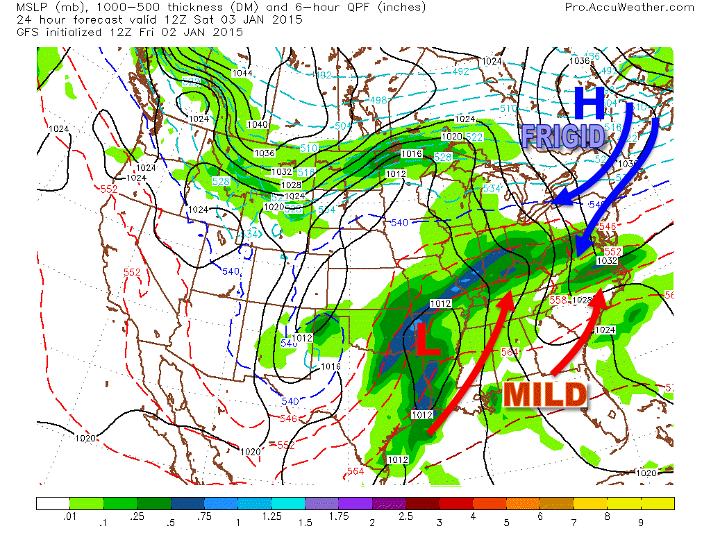
The high pressure to the north and the northerly winds it brings will lock in the cold air over the area. While the developing low will try really, really hard to push warm air into the region, it will have a very hard time succeeding especially at the surface. A few thousand feet up is another story.

There is no high pressure at 850mb (5,000 feet) so warm air can stream into the region unimpeded. This warm layer will result in a period of ice across inland areas. The mountains see ice too but only after the heaviest precip moves out. Onshore winds at the coast should warm things up enough for just rain but at least a little ice is expected there too.

The NAM, while notorious for dropping obscene snowfall and generally being useless, does have its strengths. It takes a model with resolution as high as the NAM to pick up on small features that the low resolution models can’t see.
The one feature in here that I want to elaborate on is the mesolow. This is an idea that the models have generally dropped although makes sense due to the triple point (the point at which the warm, cold, and occluded fronts meet) passing over the area and pockets of 500mb vorticy hanging out in the area as well. While the effect of the mesolow probably won’t be that big, it’s worth a mention due to the potential it has to help lock in the cold air at the surface.
Now, let’s look at each impact specifically.
Snow
Everyone starts out as snow for several hours Saturday Night. Snow will be heavy at times even at the coast and by early Sunday morning, everyone should see a few inches on the ground. Warm air will work into the region Sunday morning and we gradually flip to mixed precip and then rain.
Snow will become very heavy early Sunday morning with snowfall rates right around 1″ per hour. Steady precip goes from around 10-11PM Saturday to 11AM-1PM Sunday with the heaviest precip falling between Midnight and 6AM. Who gets how much snow depends on how much of these time windows they spend with precip falling as snow.
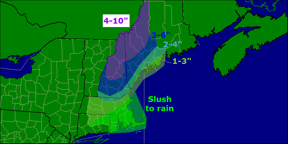
Here’s my first call on snow accumulations before the changeover. Areas in either shade of green see most of their snow melt away while areas in purple see little to no reduction of totals since the changeover will happen after the steadiest precip moves out.
ICE
Everyone will see at least a little ice, that’s for sure. As warm air moves in aloft but cold air hangs tough at the surface, snow will fall from the clouds, melt, then refreeze when it hits the ground. Inland areas stand the greatest chance for ice accumulation since cold air at the surface will hold on long enough for the warm air aloft to arrive.

Here is my first call on ice accumulations.

RAIN
Almost everyone sees rain at some point except for the Maine and New Hampshire mountains. Rain will be heavy at times across southern areas with parts of SE MA, CT, and RI seeing an inch of rain. Rainfall amounts taper off farther north as frozen precip takes up some of the QPF. Snow will move into Southern New England Saturday afternoon and quickly turn to rain before tapering off Sunday morning.
I’ll have another update at some point tomorrow afternoon or evening on the storm.
-Jack
