Today will feature light snow along with temps that will feel absolutely balmy after this past week. Snow is already widespread across the area with some bands of moderate snow moving in from the SW. Expect light to moderate snow to continue throughout the day tapering off this afternoon. Highs will generally be around freezing so this will be a heavier snow compared to what we have seen recently.
If today makes you miss the cold, don’t worry, it will come roaring back tonight and tomorrow with plunging temps and bitter winds. Another mild shot is possible this weekend.
Today will feature a period of light snow in the morning followed by a mainly cloudy afternoon. Light snow is currently falling over far western ME, and all of NH with some bands of moderate snow back across NY and MA. The snow is moving ENE for the most part and should reach the coast in about an hour or two. Accumulations are generally going to be on the light side today with a widespread coating-2″ possible. Not a lot by any means but its timing is unfortunate for commuters.
Snow clears out by 1 this afternoon, sooner as you head SW. Clouds will remain this afternoon for the most part though coastal areas should see a little bit of sun as downsloping dries out the atmosphere. A disorganized series of cold fronts will pass through tonight bringing more fresh cold air in from Canada. No significant storms are in sight.
Today will feature cold conditions as an arctic front races eastward across the area. Ahead of it, expect calm, but still cold, conditions with many areas actually above 0 this morning. When it arrives, the chance for heavy snow squalls exists which not everyone will see but could be enough to drop a coating to an inch or two in some areas. The areas with the greatest chance of accumulation are the mountains and the midcoast where an inverted trough is currently causing flakes to fly.
Winds will start blasting out of the west after the front has passed along with tumbling temps along with some more snow squalls. Wind chills will fall to dangerous levels this evening and wind chill warnings are up for the Maine and New Hampshire mountains/foothills. The rest of the area is under a wind chill advisory. Both go into effect at 5PM tonight.
Today will feature cold temps across the area with current readings in the single digits on either side of zero, even to the coast. Yesterday’s winds have tapered off as high pressure has put a plug in the wind stream so to speak, for now. However, with such cold actual temps, any breath of wind will make it feel a lot colder. Wind chill warnings/advisories are in effect for the Maine and New Hampshire mountains/foothills for this morning due to the combination of cold temps and winds.
A weak clipper system moving to our south will bring light snow/snow showers to the area this afternoon. Widespread snow shower activity is likely even outside the mountains. Since moisture is extremely limited with this system, no accumulations are expected but some flakes will by flying for sure.
Come tomorrow, we open the floodgates to even colder air so expect winds similar to yesterday’s, just with colder actual temps. Snow squalls will be widespread tomorrow with a widespread inch or so of accumulation even outside the mountains. Signals are strong for briefly white out conditions in the heavier squalls so be prepared for that as you’re out and about tomorrow. Some models have indicated a Norlun trough could bring enhanced snow to some areas tomorrow and should that happen an extra few inches is possible where it sets up. More details on that potential in tomorrow morning’s update.
Cold temps and strong winds will make today feel dangerously cold in some areas especially this afternoon. For full details, check out my update for Western Maine Weather.
While this is a pretty run of the mill storm for the area, that’s not to say it’s not without impacts. Precip is moving into the region from the west right now and a significant amount of virga is showing up on radar. Virga is the technical term for precip that evaporates before reaching the ground because of dry air.
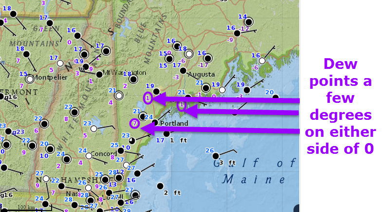
Temperatures (Blue numbers) and Dew Points (purple numbers) showing very dry air across the area this evening. Observations current as of 4:15 PM.
With such dry air in place, we’ll have to be a little patient before the first flakes will fall. By 7PM, everyone will be seeing precip with RI/CT rain, MA rain and snow, and NH/ME snow.
With such bitter cold the past few days, the temperatures on the road surfaces are well below freezing so when snow starts, we won’t have to wait long before travel becomes hazardous. With only two to three hours of snow, areas of MA and CT are already seeing very bad road conditions with snow piling up. Expect the snow and the poor road conditions to move north the next few hours.
This image looks very confusing but it boils down to how much air is moving up in the atmosphere as well as how fast it is moving up. The more air that moves up, and the more quickly it does so, the heavier the precip will be. This image shows well the potential for a very heavy band of snow/sleet/rain late tonight and very early tomorrow morning.
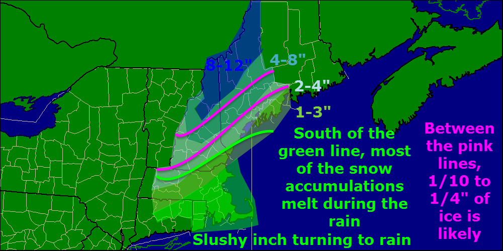
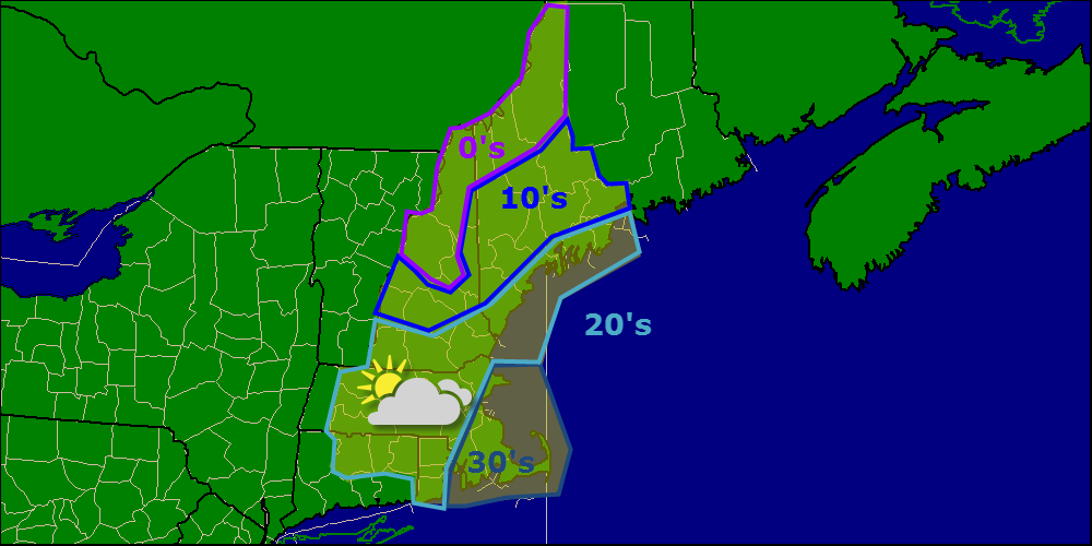
Here is the updated snow map with a few important changes. First, I have increased the mountains to 8-12 because precip wraps up around 7AM and I do not see the warm air making it up there in time for a changeover to mixed precip. I also backed off on the areal extent of the ice since mixed precip in the foothills will be more of a mix of sleet and freezing rain rather than just freezing rain.
I reduced amounts slightly for the very immediate coast since the proximity to the ocean should aid in the transition fro snow to rain. that being said, even an hour extra of snow would deliver an extra 1-2″ of snow while an hour earlier in the changeover would do the opposite. This is a fairly uncertain forecast for the coast so be prepared for a little more and know that there is the possibility for a little less.
One important feature I should make note of which is a little bit of a wild card is a low pressure area that is developing off the Carolina coast. This is developing a little farther south and a little more quickly than anticipated which could have significant consequences down the road. This low will help turn winds more northerly and will thus help lock in the cold air across the region at least at the lower levels of the atmosphere.
As far as timing goes, some light snowflakes are being reported around the area now with heavier snow back towards MA/CT/RI. Expect snow to develop quickly from here on out and become steady and moderate. The recent cold has left roads and sidewalks very chilly so as soon as snow starts falling expect slick roads. We have seen very bad road conditions in this snow band across MA and CT. As the band moves northeast, expect the bad road conditions to as well.
The heaviest snow will occur between 10PM and 4AM tapering off as we get closer to dawn. Scattered drizzle, both liquid and frozen, will last a little longer before finally dissipating midday tomorrow. Temps will warm right up tomorrow as we sit in the warm sector of the low so expect highs in the 30’s and 40’s. Temps crash Monday with brutal cold returning next week. The coldest day looks to be thursday with highs struggling to get above 5 degrees. The mountains of ME and NH look to see highs remaining below zero. More details on that in the coming days.
Today will be a cold one especially this morning Temps right now are in the single digits on either side of zero across ME and NH with a few low 10’s along the coast. 10’s and low 20’s are widespread in SNE this morning which means we have plenty of cold air to work with. Highs today will range from roughly 5 to 36 under some high clouds.
I’ll have a more detailed update on the storm this evening.
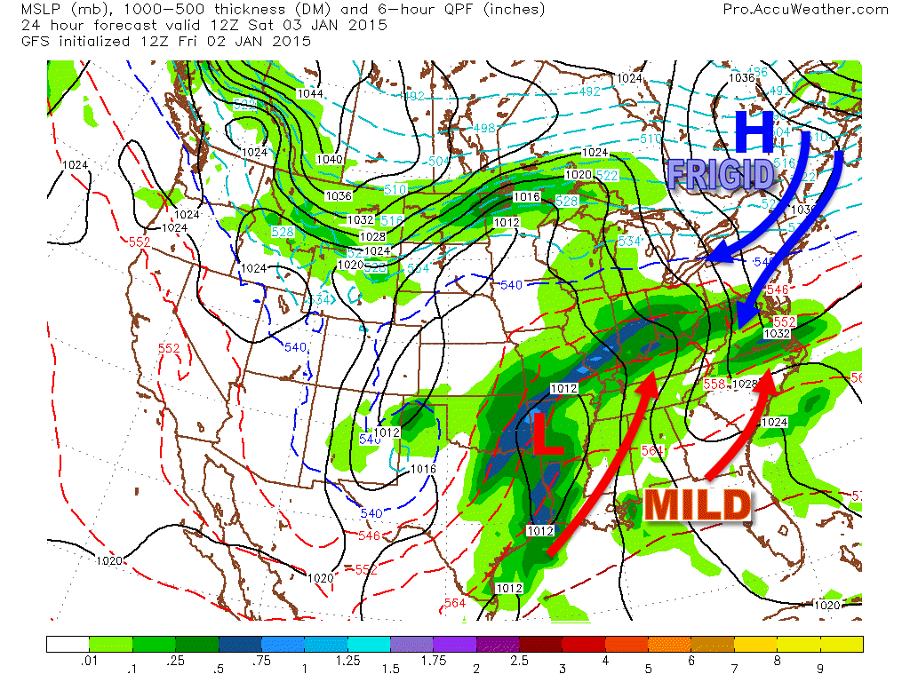
I hope everyone has had a wonderful holiday season this year! Sorry for the lack of posing the past week, I decided to take some time off and spend time with family while the weather was quiet. Well the weather is quiet no more as low pressure moves up the Ohio Valley bringing rain, ice, and snow to the region this weekend.
The storm will track to the west of us this weekend which usually means flat-out rain for all. However, a sprawling high pressure system and deeply entrenched Arctic air has other ideas…
12Z GFS Valid 7 AM Tomorrow Morning Showing The Arctic High Locking In Cold Air Over The Region.
The high pressure to the north and the northerly winds it brings will lock in the cold air over the area. While the developing low will try really, really hard to push warm air into the region, it will have a very hard time succeeding especially at the surface. A few thousand feet up is another story.
12Z GFS Valid 7 AM Sunday Showing Warm Air Streaming Into The Region At 5,000 Feet
There is no high pressure at 850mb (5,000 feet) so warm air can stream into the region unimpeded. This warm layer will result in a period of ice across inland areas. The mountains see ice too but only after the heaviest precip moves out. Onshore winds at the coast should warm things up enough for just rain but at least a little ice is expected there too.
12Z NAM Valid 7AM Sunday Showing Various Wind Features That Will Determine Local Precip Types.
The NAM, while notorious for dropping obscene snowfall and generally being useless, does have its strengths. It takes a model with resolution as high as the NAM to pick up on small features that the low resolution models can’t see.
The one feature in here that I want to elaborate on is the mesolow. This is an idea that the models have generally dropped although makes sense due to the triple point (the point at which the warm, cold, and occluded fronts meet) passing over the area and pockets of 500mb vorticy hanging out in the area as well. While the effect of the mesolow probably won’t be that big, it’s worth a mention due to the potential it has to help lock in the cold air at the surface.
Now, let’s look at each impact specifically.
Snow
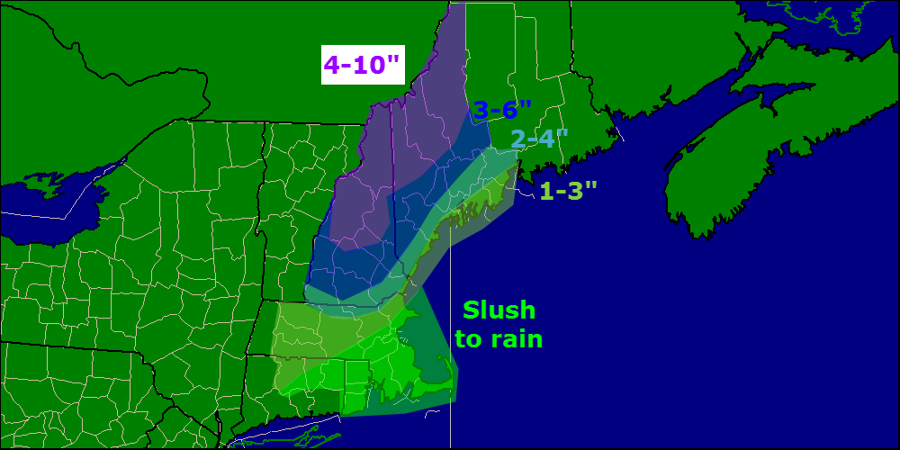
Everyone starts out as snow for several hours Saturday Night. Snow will be heavy at times even at the coast and by early Sunday morning, everyone should see a few inches on the ground. Warm air will work into the region Sunday morning and we gradually flip to mixed precip and then rain.
Snow will become very heavy early Sunday morning with snowfall rates right around 1″ per hour. Steady precip goes from around 10-11PM Saturday to 11AM-1PM Sunday with the heaviest precip falling between Midnight and 6AM. Who gets how much snow depends on how much of these time windows they spend with precip falling as snow.
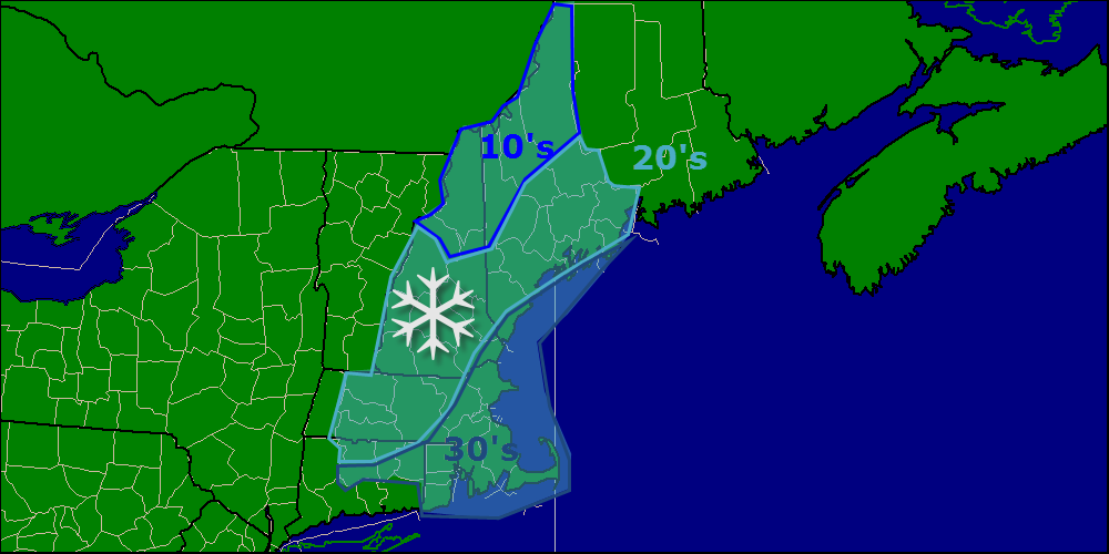
Here’s my first call on snow accumulations before the changeover. Areas in either shade of green see most of their snow melt away while areas in purple see little to no reduction of totals since the changeover will happen after the steadiest precip moves out.
ICE
Everyone will see at least a little ice, that’s for sure. As warm air moves in aloft but cold air hangs tough at the surface, snow will fall from the clouds, melt, then refreeze when it hits the ground. Inland areas stand the greatest chance for ice accumulation since cold air at the surface will hold on long enough for the warm air aloft to arrive.
Here is a quick explanation of freezing rain. The image is from the NAM for Rumford Maine Valid 7AM Sunday.
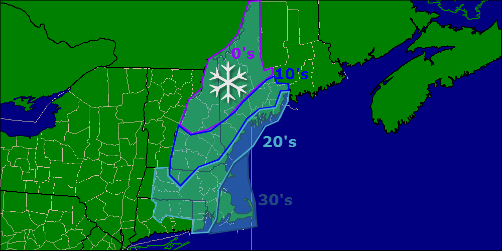
Here is my first call on ice accumulations.
RAIN
Almost everyone sees rain at some point except for the Maine and New Hampshire mountains. Rain will be heavy at times across southern areas with parts of SE MA, CT, and RI seeing an inch of rain. Rainfall amounts taper off farther north as frozen precip takes up some of the QPF. Snow will move into Southern New England Saturday afternoon and quickly turn to rain before tapering off Sunday morning.
I’ll have another update at some point tomorrow afternoon or evening on the storm.