
Hello everyone!
Not much has changed from earlier updates regarding the incoming round of snow. Still a tricky forecast as whoever sits under the band the longest sees quite a bit of snow while everyone else sees much less accumulation. The storm will have two basic phases, the trough then the low. Let’s look at the trough first.
The first phase of our storm will involve the development of an inverted trough. While this is similar to a Norlun trough, a true Norlun event would involve a stationary band of snow whereas this band will likely move slowly east with time. Therefore it will be referred to as an inverted trough for this event.
Snow has already broken out across Southern Coastal ME with the bulk of the activity being across York County as of now. This will likely continue through this evening before activity shifts NE tonight. Snowfall rates will be very high in this band with 1-3″ per hour likely in the heaviest snow. The band will continue to develop this evening over York and Cumberland Counties before expanding inland and eastward through the morning. Midday tomorrow is when the next phase of the storm starts.

Once again, we look to the upper air map to tell us a lot about the storm. Let’s start with the dark blue circle over upstate NY/Southern Ontario. This is the closed upper low (note little black circle). This will add a snow squall dimension to the forecast especially over the mountains tomorrow. By snow squall, I really mean pockets of heavy snow as the trough should extend far enough inland to bring everyone some snow.
Next let’s focus on the green dashed line and green arrows. As a vigorous pocket of energy rounds the base of the trough tonight (yellow circle, has other implications later), the trough axis will be oriented from NW to SE, known in the meteorology world as a negative tilt which will turn the winds aloft out ahead of it to the SE (green arrows). When there are SE winds aloft, Atlantic moisture begins to become wrapped into the storm and more widespread snow soon follows. For this reason, even areas that don’t see the inverted trough band will see decent accumulations. Just a quick note, the light pink line over Maine shows the energy left over from the trough as it weakens and moves east.
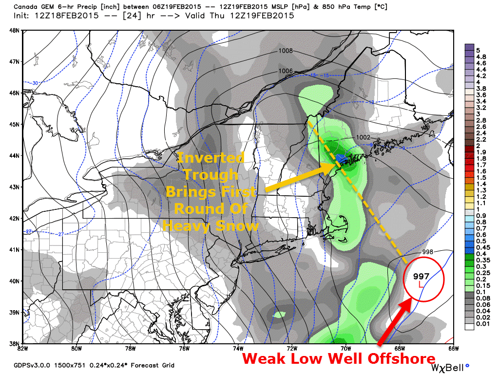
The yellow circle off the coast is the final feature that I will point out on the map. Notice all the purple/white inside that circle. This is the vigorous energy that a. tilts the trough negative and b. forms a new storm off the coast. This is the second phase of our storm.

Once the new low forms offshore, intense upward motion will begin across areas NE of Portland Thursday afternoon. How far west the precip builds back is still questionable though it shouldn’t get past Portland. This part of the storm will most severely impact the midcoast as the low passes east. Winds will pick up as well as the storm strengthens so watch for even more blowing and drifting Thursday afternoon and evening.
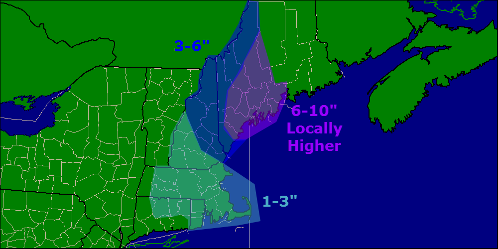
Here is my snow map, uncertainty still exists but I think someone along the midcoast sees a foot maybe a little bit more.
I’ll have another update tomorrow morning.
-Jack

