
Hello everyone!
Clouds will be on the increase today as yet another storm approaches from the west. Expect a very chilly start with most areas seeing double digits below zero this morning. However, temps will warm swiftly during the day as light southerly winds bring in warmer air. Most of us will end the day in the 10’s to low 20’s.
Snow will begin in the afternoon hours and will spread east during the evening. Expect a light snow for most areas with some moderate bands working their way in along the coast in the evening hours. Inland areas see mainly a dry and fluffy snow though some wetter snow is possible early tomorrow morning. Coastal areas see heavy wet snow and then have a shot at some rain too. This combined with the snow we’ve already had this winter will put a tremendous load on roofs so please shovel your roofs off today.

By evening, everyone is seeing snow, moderate at times, with temps slowly rising through the 20’s. It will be a race between the departing precip and the warming temps to see who gets rain. Most of the precip is out of here by midmorning tomorrow and only the islands/peninsulas should see rain by then.
Almost everyone goes above freezing for the first time in quite a while tomorrow afternoon after the ‘cold’ front comes through and shifts winds to the west. This will act to mix out the cold air that is in place and thus cause temps to rise. This is because the cold air that is in place during the storm is allowed to be in place because the air is not all that turbulent. The air from 10,000 feet is not going down to 5,000 feet and vise versa. Only when the front comes through and the air is moving up and down as well as horizontally can you bust open the cold dome that is in place.
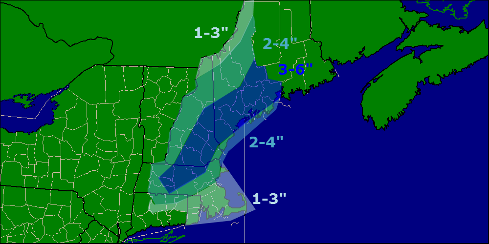
Here is my thinking as to snowfall accumulations. On the south side of the 3-6″ zone accumulations will be limited by mixing with rain/freezing rain. It should be noted that since ground temps are so cold, any rain that falls will freeze on exposed surfaces like plowed roads or driveways so beware of icy spots if rain falls.
-Jack
