Looking Ahead To Yet Another Large Storm

Hello everyone!

Today will be a quiet one with mainly clear skies, Rather cold temps, and breezy but not extreme winds. Expect highs in the single digits above or below zero in the northern mountains and 10’s in the south. Winds will make it feel even colder and expect subzero wind chills all around for the duration of the day today.

Tomorrow will start out very cold. Low temps will be in the single digits below 0 right at the immediate coast and will drop into the 10’s below 0 only a few miles inland. 20 below 0 readings are likely to make an appearance in the mountains. Winds should be lighter at this time so wind chills will not be as much of an issue. Clouds will be on the increase tomorrow and light snow should begin in the early afternoon.

0Z GFS Showing Very Highs Winds Along The Coast. Note, Map Wind Values Are Just One Model Idea And They Are Also In Knots. Credit: Accuweather.

Snow increases in intensity tomorrow all around with bands of 1-3″ per hour likely by sundown. Winds will begin to crank as well when the storm begins to bomb out tomorrow night. The very strong winds will cause two problems, first lots of blowing snow. Remember, we have a 24-36″+ snowpack already in place. This means that many of the shrubs and grasses that usually stop the blowing snow in its tracks are now buried thus increasing the blowing snow potential significantly.

The other problem the wind creates is wind chill. Temps will be very cold during the storm – between 0 and 10 degrees – so add some 40-50 MPH+ wind gusts and you get really cold wind chills. Should you decide you need to go out Sunday (not advised) beware dangerous cold will be present. The good news is that the cold brings light and fluffy snow which is easier to shovel.

I’ll have a full update on the storm tomorrow.

-Jack

Light Snow Today, Not So Light Snow Looking More Likely Sunday

Hello everyone!

Today will feature increasing clouds in the morning followed by some light snow in the afternoon. Expect minimal accumulations in the coating-2″ range with the highest amounts along the coast. Snow will be steadiest in the afternoon and evening hours so the PM commute is when some slick spots are likely to be found. Snow wraps up later tonight before the sun makes an appearance tomorrow. Highs today will be in the 10’s to low 20’s.

Tomorrow will feature clearing out along with some NW wind gusts and falling temps. Highs will be in the 10’s for most with some single digits possible in the mountains. Wind chills will drop below that however making it feel a lot colder.

0Z GFS Showing Brutal Cold Satuday Morning. Image Credit: Weatherbell
0Z GFS Showing Brutal Cold Saturday Morning. Image Credit: Weatherbell

Saturday will start out extremely cold with lows below 0 for all and wind chills well below that. Wind chill advisories have been issued for the mountains so be sure to bundle up should you venture out Saturday morning. By later in the day Saturday, clouds will be on the increase and some snow could start to break out in advance of our not-so-light snow event.

There is a lot of uncertainty with our next storm however things are coming more into focus. Some sort of storm looks very likely and a significant storm is certainly possible. While it is too early for exact amounts, there is a very high likelihood of 6″+ with 12″+ not unreasonable. Both the GFS and the Euro give big storms with the Euro probably a tad overdone. I’ll have more details on this threat as it gets closer but I wanted to put it out there as our next major threat.

Yet another storm is looking more and more likely for the middle of next week which has the capability to bring even more snow.

-Jack

Chilly but not snowy today

Hello everyone!

Today will feature conditions a lot like yesterday – sunny, not snowy, and reasonably warm – with the one difference being temps about 10 degrees colder. Highs will be in the 10’s for most with 20’s south under full sun. Some clouds may start to sneak in this afternoon but the bulk of the overcast looks to hold off until tonight.

Those clouds coming in tonight are in advance of our next storm which will bring more snow but not a lot. Expect a general 1-3″ which will hardly be noticeable compared to some of our previous storms. Despite the low numbers, this will wrap up right around the AM commute Friday so watch for some slick spots on the roads then. Our next threat arrives Saturday into Sunday with another threat Tuesday into Wednesday. More details on those later.

-Jack

Clearing Out Today, Getting Colder Too

Hello everyone!

Today will feature clearing skies as our storm from the past several days moves out. Expect the day to start with clouds and some snow along the coast before the sun makes an appearance for all. Snow should end pretty early this morning while the sun will lag behind a little bit taking until midday to make an appearance. Highs will be toasty by recent standards reaching 20 in the north and 30 in the south. Winds will be mainly light out of the north though a few gusts around 20 are possible mainly at the coast which could lead to some isolated blowing and drifting.

Looking ahead, ready for more? Pick your model, pick your storm. GFS – Thursday, Euro – Sunday. More details on those later.

-Jack

Snow Moves Out This Morning, Cold Air Moves In

Hello everyone!

Today will feature morning snows with some accumulations expected however it will be a drop in the bucket compared to last week’s epic blitz. 3-6″ are expected along the coast with lesser amounts inland. Snow moves out later on this morning as another cold front pushes through.

Behind the front, NW winds will pick up bringing more cold air into the region and this morning’s mild temps (hey! we’re up to 30!) will quickly tumble back down into the single digits and lower 10’s by dusk. Gusty winds will continue as well bringing wind chill values back below 0. Dangerous wind chills on the order of 30 below or colder are expected in the moutnains so watch out for those if you’re heading north this evening.

Sun should also make an appearance this afternoon with clearing occuring around noon from NW to SE. Lows tonight will range from 25 below in the valleys up north to 5 below at the coast. No more significant storms are in sight though more light snow is possible early next week. More details on that later.

-Jack

More Snow On The Way Tonight Into Tomorrow

Hello everyone!

Special brief update this evening to cover the next shot of snow that will be impacting the region through tomorrow morning. A few flurries fell today,  as expected, in association with an arctic front that will set the stage for tonight’s steadier snow. Flurries will continue to hang around tonight so some locally slick roads are possible with most of the activity being focused over southern, coastal areas.

snow map 2-4

My thinking as to accumulations has not changed since this morning so the map remains the same. A wave of low pressure will ride up the front tonight bringing steady light to moderate snow lasting until mid-morning tomorrow. Snow activity will be focused along the coast and eastern areas where 3-6″ will likely fall compared to the mountains which should escape with nothing more than a dusting.

As for the next storm threat, it comes Sunday into Monday and all options are on the table from a big storm to cold and clear. More details on that as we get closer.

-Jack

Active Pattern Continues – More Flakes Set To Fly This Week

Hello everyone!

Tired of snow? That could be a problem as we have several storm threats lined up for the next few days that all have the chance to bring accumulating snow to the region. Our first threat, is today into tomorrow.

Today will feature some snow showers/flurries as a weak front moves through. Very little accumulation is expected with a coating to an inch expected under the heaviest of showers. Expect much warmer temps today with inland areas in the 20’s and the coast making a run at the freezing mark (the islands and the peninsulas should get there).

However, all good things must come to an end and as the arctic front pushes offshore, much colder air moves in which sets the stage for our next snow event tomorrow morning. A wave of low pressure will develop to our south and ride NE along the front, wherever the front may be. If the front is slower and stalls farther west, the storm tracks farther west and we get more snow. The opposite would happen if the front moved through a little faster and the storm shifted farther east.

snow map 2-4

Here is what I expect snowfall totals will be when this storm wraps up midday tomorrow. The heaviest snow will fall during the AM commute which could cause some traffic problems. This will be a wetter snow than most of our recent events and some raindrops could mix in on the outer parts of the peninsulas. Otherwise, this is another all snow event.

Our next threat is already lined up for Sunday into Monday. Still way too early for details but there is some serious potential as cold air will be in place and moisture will be organizing to our south. Stay tuned for later updates regarding that threat.

-Jack


Calm But Cold Today

Hello everyone!

Today will be calm and quiet as far as the weather goes with clearing skies and highs in the single digits north to teens south.  In addition to cold temps, there will be some wind and NW winds will keep wind chill values well below zero throughout the day. Some residual blowing/drifting is possible as the winds combine with yesterday’s snow so watch for some slick spots and some patchy reduced visibility.

-Jack

More Snow And Wind Today

Hello everyone!

Today will feature yet another snowstorm across the area with widespread heavy falling and blowing snow. Last night’s forecast remains very much on track as snow begins to overspread the region this morning. Check back there for the detailed impact-by-impact breakdown as well as timing. All the thoughts there still ring true this morning.

snow map 2-1

Expected snowfall through tomorrow morning.

-Jack

Yet Another Winter Storm Set To Roll In Tomorrow

Hello everyone!

Yet another winter storm is headed our way so it is again time to break it down, impact by impact. Below I’ll take a look at some of the factors driving the storm and what these factors mean for the forecast.

2015-02-01_18-59-55

Lets start with a look at the current radar showing the storm across the Great Lakes. Snow is already getting close to NYC which is right on track. Snow should arrive here in Maine early tomorrow morning. More details on the timing below the impacts section

Snow

There are several important factors I want to go over before putting out the snow map. I hope this will help you to understand some of the factors at play here and why this is a pretty tricky forecast for many areas.

0

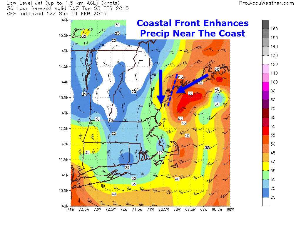
Here is the GFS Low Level Jet map (courtesy of Accuweather) which helps to illustrate one of the factors that goes into the snowfall forecast and that is the coastal front. We get coastal fronts in most of our winter storms and they are basically a boundary between E/SE winds (warmer air) and N/NE winds (colder air). When winds collide like this (see map for wind arrows), the air has to go up and when air goes up, it snows harder. For this reason, higher totals are expected along the coastal front as this is one area to watch for mesoscale band development.

00

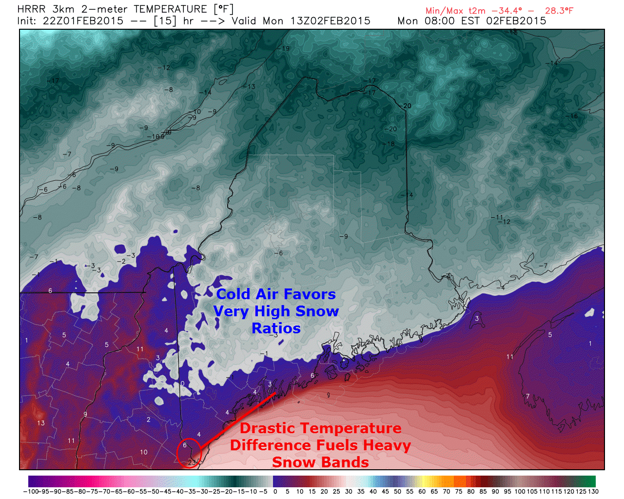
The HRRR temperature map for 8AM tomorrow (courtesy Weatherbell) illustrates two very important factors to consider when figuring out snowfall. First off is our coastal front I talked about earlier. Notice the extreme temperature gradient all along the coast. This thermal gradient is one of the important pieces of the coastal front and will likely drive heavy snow bands along the coast.

The other piece of the puzzle the temp map shows is the very cold temperatures across the area. This very cold air supports very high snow ratios on the order of 18:1-24:1 which is extremely fluffy. For reference, the blizzard brought widespread 20:1 snow ratios and the storm on Friday brought snow ratios closer to 10:1. Even though not a whole lot of liquid will fall, the snow ratios should more than make up for it.

It should be noted temperatures are not the only factor behind snow ratios, one could go into great detail about crystal type and snow growth (which by the way is excellent) among other things but temperatures are the main factor that drives fluffy snow vs wet snow.

snow map 2-1


Here is the snow map. Watch out for isolated 14-20″ amounts in the purple are, hence the + sign.

Wind

000

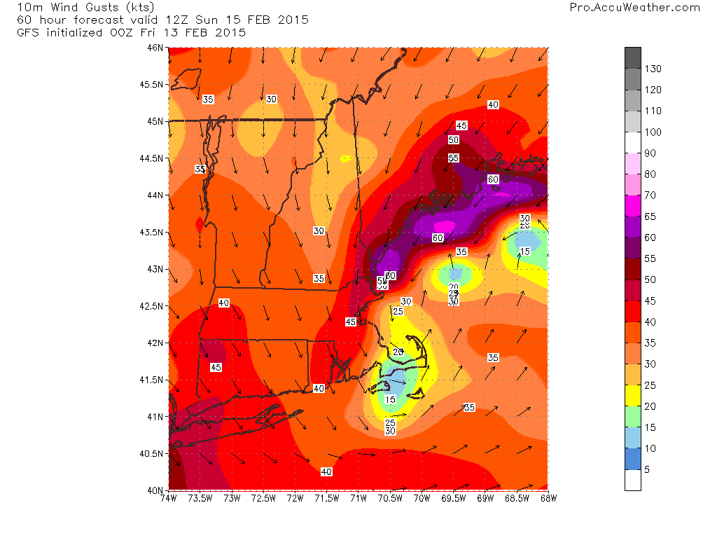
As with any coastal storm, wind will be a factor tomorrow. Winds will mainly be from the N/NE and could gust over 45mph at times along the coast. The map shown is the GFS wind gust map (Courtesy Accuweather) showing the highest winds zoned in on the coast. Keep in mind the numbers here are in knots so MPH values will be slightly higher.

High winds + dry fluffy snow = blowing and drifting. We’ve been here before and while no conditions experienced in tomorrow’s storm will rival that of the blizzard’s, localized whiteouts are possible especially along the coast where the highest winds are expected.

No sleet or freezing rain is expected to make it up here into Maine though areas south of the mass pike are at risk for sleet and ice which will keep totals down slightly. Cape Cod will mix with rain for a period of time as well so totals will be a good deal lower out there.

Normally coastal flooding would be an issue however the peak surge will occur during low tide so any coastal flooding impacts will be limited to isolated splashover/beach erosion.

Timing

Tonight: Increasing clouds, no snow yet. Travel impacts: None.

Tomorrow Morning: Developing Snow becoming moderate to heavy by midmorning. Winds will be picking up as well which will start the blowing and drifting. Travel impacts: Moderate/Major.

Tomorrow Afternoon: Moderate/heavy snow and wind. Travel impacts: Major.

Tomorrow Night: Snow winding down and tapering to flurries across SW areas. Moderate snow continues across NE areas. Travel impacts: Moderate/Major.

Tuesday Morning: Snow tapers to flurries everywhere, NW winds continue blowing/drifting. Travel impacts: Minor/Moderate.

All in all, nothing spectacular but it will make the snowbanks that much higher and the skiing that much better. More snow is possible Wednesday, more details on that in later updates.

-Jack