Today will feature mainly cloudy skies and warmer temps as an Arctic front approaches the area. Another storm is passing to our south and could bring a few flakes to the midcoast region. Highs today will be mild by comparison to recent days reaching the 30’s region-wide. It won’t last long however as the Arctic front will bring another blast of bitter air for tomorrow along with, you guessed it, more wind. This round of wind will not be anything like the one we saw earlier this week but it will still drop the wind chills down to levels that will be far from comfortable.
No significant storm threats are in sight as of now.
More clouds are on tap for today as a storm brushes by to our south. Precipitation associated with the storm will impact southern New England where a coating to 2″ of snow is expected. North of Portsmouth, no precip is expected and a cold and cloudy day is anticipated. Temps this morning are extremely chilly with some subzero readings in the mountains and single digits making it all the way to the coast. Temps will however warm up quite nicely into the upper 20’s north and low to mid 30’s south.
No significant storms are on the horizon as of now.
Today will feature conditions similar to yesterday with one exception: much less wind. That being said, winds will still be busy this morning but will relax this afternoon as high pressure moves in. Skies will once again be sunny and temps will once again be chilly with highs ranging from around 15 in the mountains to around freezing at the coast. Despite the continued cold, it will feel much warmer today as winds die down and the wind chill becomes less of a factor.
No significant weather events are in the forecast for the forseeable future.
While Astronomical Spring is just 2 days away, it sure will feel like winter out there today. Winds have been up out of the northwest all night with many areas gusting over 40 MPH. Winds will continue at that force throughout the day today as cold air continues to push in. Highs today will also be brutally cold as temps struggle into the single digits in the mountains and 10’s inland. The coast gets lucky here as downsloping warms them up into the mid to upper 20’s.
HRRR Model Showing Bitterly Cold Wind Chills This Morning. Credit: Weatherbell
Wind chills will also be a factor this morning as bitterly cold temps combine with strong winds. Bundle up if heading outside today!
Today will feature rain or snow showers depending on your location as an Arctic front pushes through the area. Expect snow showers turning to rain showers along the coast and in the foothills while the mountains stay snowy. The front itself will push through late this morning and behind it NW winds will begin to blast the region full force as more cold air moves in. An area of low pressure will develop to our SE along the front and intensify as it moves towards Atlantic Canada. Eastern areas will see some light snow out of this however the main impact will be the strong winds that will continue through tomorrow.
As for temps, today will be a warm one ahead of the front with coastal and inland areas rising into the 40’s and the mountains making it all the way into the low 30’s. Behind the front, temps will tumble into the 10’s and single digits tonight with a strong wind making it feel much colder. Wind chill values will likely dip into the 20 below range in the mountains while the coast sees wind chills in the single digits below zero tomorrow morning. Welcome back to winter!
Today will feature beautiful weather region wide as NW winds help the coast and foothills warm into the 40’s under full sun. The mountains will see a mix of sun and clouds though the trend even there should be on the sunnier side as low level moisture is severely limited. We will see a few high clouds by afternoon though as our next frontal system moves in. As for temps in the mountains, low to mid 30’s are expected.
Tomorrow looks to be a nice day as well ahead of our next front though Wednesday looks to be a bit cooler. No significant storms are in sight.
Our storm is moving out this morning and most of the accumulations are done with the exception of NE areas where heavy snow bands will continue for another few hours. For the rest of us, some dry air at around 10,000 feet is causing precip to shut off and thus most of southern Maine is now dry.
That’s not to say precip is completely done, the upper low is only just beginning the process of moving through the area and everyone will likely see another round of snow this afternoon as it finishes its crossing.
HRRR Model Simulated Radar Animation. Credit: Weatherbell
Here is the HRRR model showing one more round of snow this afternoon before the storm moves out for good. Expect these snow showers/squalls to be heaviest between 1 and 6 PM this evening before moving out around 8 or 9 PM tonight.
Temps will be falling today starting in the 30’s this morning and crashing through the 20’s this evening. The mountains will likely see readings in the 10’s while the coast likely stays in the 20’s.
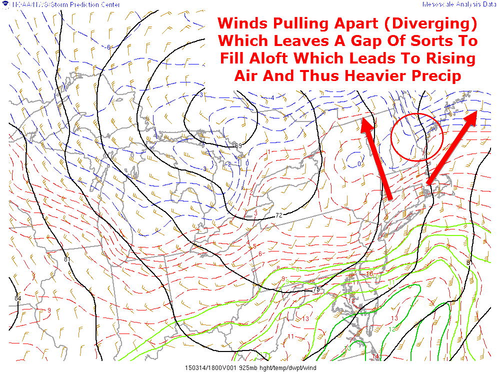
Precip is already falling across much of the area as our next storm moves in. Expect snow to flip quickly to freezing rain/rain along the coast but remain all snow inland this evening. Currently, some weak divergence aloft is causing a heavy snow band to move through Cumberland County on its way NE.
925mb Analysis Showing Divergence Aloft Over Southern Maine/New Hampshire
This divergence is causing a brief heavy snow burst which, despite warm temps, is accumulating on some of the roads so use caution if you happen to be driving this afternoon.
3:30 PM Radar Showing A Heavy Burst Of Snow Moving NE Across Coastal Areas
Warmer air will continue to flood into coastal regions this afternoon though after looking at data from a special sounding (vertical profile of the atmosphere) from the NWS in Gray, models appear to have had a warm bias with this event and thus a tad more frozen precip is expected especially away from the immediate coast.
HRRR Model Simulated Rader Animation. Credit: Weatherbell
Here is the HRRR model’s take on what the first phase of our storm will look like through the wee hours of tomorrow morning. This model does a good job showing the rain/snow line advancing this evening with heavy snow across the interior and rain across coastal areas. I would advise taking this model with a grain of salt however as it shoots the rain line past Lewiston. When accounting for the warm bias of the models for this event, the rain line should approach the Lewiston area but is not likely to pass it especially considering the snowpack we still have on the ground.
12Z GFS Upper Level Energy Map. Credit: Weatherbell
The second phase of the storm occurs tomorrow when a strong upper low crosses the area. Expect temps to crash tonight as NW winds behind a developing secondary low move cold air into the region. As a result, tomorrow’s part of the storm will be an mostly snow event which is where the coast picks up their accumulation. There is still some debate as to if/when/where an inverted trough might setup to help focus the precip so uncertainty still remains. Precip looks to move out tomorrow evening from west to east.
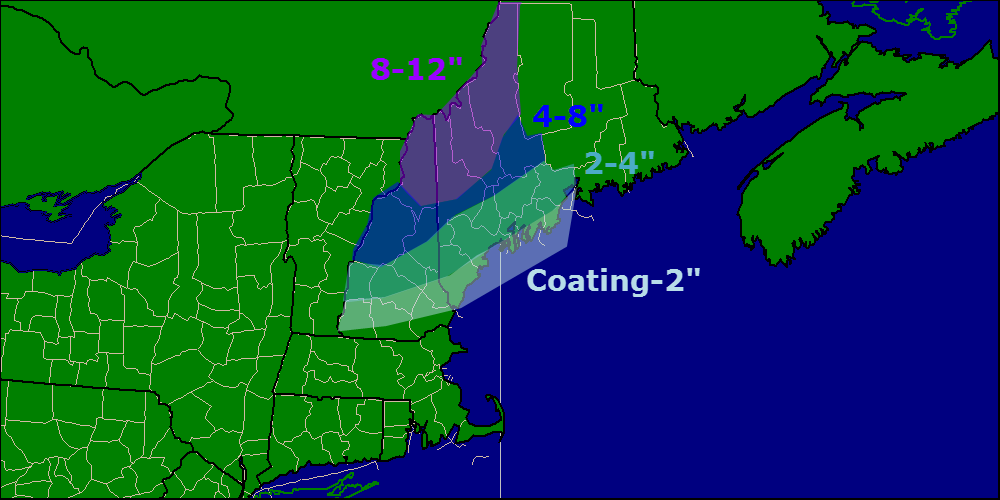
Here is the latest snowfall forecast showing the coast escaping with little more than a dusting while the mountains see the jackpot with 8-12″. Due to warmer temps, this will be a wet and heavy snow so watch for a few isolated power outages as trees sag under the weight of the snow.
Quickie update this morning with a few minor changes to the forecast. Clouds are already in place across the area along with a few spotty flakes here and there as precip tries, and for the most part fails, to break through some very dry air. Precip should finally break through the dry air early this afternoon with snow breaking out from SW to NE between 12 and 3 PM. Precip will be rain at the immediate coast all the way until the secondary low gets going this evening. For full details on the storm forecast, check out last night’s post.
Another storm is on the way this weekend and while much of the Northeast US sees rain and 40’s for this storm, we lucky Northern New Englanders will likely be seeing more snow. While this will not be a big storm by any means, especially compared to others this winter, it will put a temporary pause on the arrival of Spring.
Water Vapor Image From This Afternoon Showing The Two Features That Will Bring Snow To The Area This Weekend. Credit: SSEC
Looking at the setup for our weekend system, two main features present themselves: a plume of moisture and warm air heading north from the Gulf Of Mexico and an Arctic disturbance racing SE to meet the moisture. How much cold makes it south and how far it gets will be crucial to determining how much snow falls.
12Z GFS Valid At 1 PM Tomorrow Showing Warm Air Streaming In At 2500 Feet. Credit: Accuweather
Before precip even starts, SW winds aloft will be allowing warm air to stream into southern parts of the region resulting in very little snow on the front side of the storm. Winds aloft are far weaker inland and thus above freezing air should be mainly a coastal issue with the foothills briefly getting in on the action tomorrow afternoon.
12Z NAM Showing Warm Air Working In Aloft But Staying Firm At The Surface. Vertical Temp Profile For Augusta, Valid At Midnight Tomorrow. The Red Line Indicates The Temperature.
Warm air will also be working in at the surface but with 1-3′ of snowpack still on the ground, warming aloft may outpace the warming at the surface tomorrow morning so a brief period of sleet/freezing rain is possible along the coast and just inland as well. While this doesn’t look like a major concern, watch out for some extra slick spots tomorrow morning.
12Z GFS Showing A Lack Of Intense Upward Motion Resulting In A Lack Of Heavy Precip. Image Credit: Accuweather
Another key difference between this storm and others this season will be that precip this time around will be a lot more on the steady side rather than extremely heavy. The GFS vertical velocity map above shows this well. Notice the lack of pinks/reds and the introduction of more gentle oranges. This translates to light to moderate precip rather than heavy precip.
Expected Precipitation Type For This Storm
By tomorrow afternoon, the warm air will have made its farthest push inland with temps both above freezing both aloft and at the surface all the way into the foothills. During the heaviest rain, flooding could be an issue along the coast where rain and snowmelt could combine to cause some minor street flooding Saturday afternoon/evening. Any impacts from flooding should be minor but it is something to watch for especially along the coast.
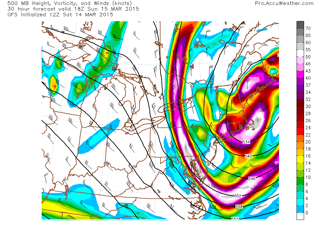
12Z GFS Showing A Strong Upper Low That Will Help To Extend Snow Well Into Sunday. Credit: Accuweather
The final phase of the storm will come Sunday as an upper low dives SE across the area. This will help to continue snow across the area on Sunday which is when coastal areas see most of their accumulations. Flakes will be flying as far south as SE MA but no accumulation is expected south of Boston.
12Z Canadian Model Showing Snow Lingering Into Sunday Afternoon. Map Valid 1 PM Sunday. Credit: Weatherbell
Snow on Sunday will be lighter and more showery in nature but it will help to keep roads slick and flakes falling for most of another day.
Taking a look at accumulations, the highest totals will be in the mountains where the cold air will hang tough the whole way through. Amounts drop off towards the coast with Southern New England seeing no accumulation at all.