Warm and Wet Today

Hello everyone!

A cold front is approaching from the west today so expect mild temps out ahead of it today as well as some showers which are currently fairly widespread mainly across the eastern half of the region. Expect showers to mainly clear out by noon or a little before with scattered sprinkles hanging around after that mainly in the mountains. Highs will rise up into the 50’s north and 60’s south.

HRRR Model IDEA On How Rain Evolves Over The Area Today. Credit: Weatherbell

-Jack

Fading Sun Today

Hello everyone!

Today will feature a chilly start under sunny skies but temps rebound a bit this afternoon as clouds move in. Said clouds will likely limit daytime highs a bit by blocking the heating effect of the sun so highs this afternoon look to be around 50 cooler up north and at the immediate coast where an onshore wind will act to cool things down. Clouds move in around noon at the coast and later in the afternoon inland.

-Jack

Cold and Windy Today

Hello everyone!

Today will feature breezy NW winds which will pile on to already chilly temps to create wind chills that feel more like late November than late October. Actual highs will struggle to 50 along the coast with upper 30’s to low 40’s inland. Wind chills however will make things feel like anywhere from the upper 20’s north to the upper 30’s south. The moral of the story: bundle up. On the bright side, the sun will be shining!

-Jack

Cool With A Chance Of Showers

Hello everyone!

Today will feature mainly cloudy skies as a cold front nears and crosses the region. Expect some showers along with that this morning and highs highly location dependant, near 50 up north but getting up to 60 down south.

-Jack

Cooler Than Yesterday But Still Nice

Hello everyone!

Yesterday morning’s front has shifted south and high pressure is poised to build in from the north. Expect a varying degree of sun today with more sun north and less as you go south. While southern areas do look to see a fair amount of clouds, precip is unlikely. Winds will be out of the NE today so as a result, cooler temps look to be found along the immediate coast with some more clouds and the outside chance for some drizzle as well mainly across peninsulas and islands. Highs will range from the mid to upper 40’s northeast to mid 50’s west with temps around 50 for most.

-Jack

Warm But At The Price Of Clouds And AM Rain

Hello everyone!

After a chilly weekend, many I know were hoping for a rise in temps, and wish granted! Temps rise into the 50’s and 60’s today with warmest temps SW but we’ll have to put up with some showers first. Most showers have already exited off the coast but scattered precip mainly of the rain variety is still lined up to our west. Rain will be light in intensity and should let up by 9 AM or so. Clouds will still rule the day in the afternoon though some sunny breaks are likely south and west. Winds will be breezy today out of the south/south-west.

-Jack

Cool Clear And Calm Today

Hello everyone!

Today will feature cool clear and calm conditions for most of the area as high pressure builds in. Expect temps this morning to be very chilly starting out in the teens north to twenties south and getting up to around 40 north and around 50 south. Mainly sunny skies will dominate today but do expect some clouds north and west later in the day as a front approaches.

For those who may be interested, check out yesterday’s post on Virga which nearly everyone saw yesterday. It’s a pretty cool phenomenon that is actually quite common in Maine during the winter!

-Jack

Neat Weather Tidbit – Virga, The Mysterious Vanishing Snow

Hello everyone!

Back again this evening with another neat tidbit about Maine weather, this time: the term/phenomenon Virga.

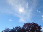
I tweeted this afternoon about a neat phenomenon I observed known to the weather community as virga. Very cold air aloft and some slight daytime heating at the surface combined to create some instability clouds/showers today across the area. Many areas saw their first flakes today but here in Yarmouth, extremely dry air at the surface prevented any flakes from making it to the ground though plenty were seen falling high above.

2015-10-18_17-35-06

Virga occurs when precipitation falls out of a cloud into a very dry atmosphere below the cloud. The precip then evaporates leading to a dry surface while a healthy shower occurs above. This phenomenon creates a neat visual effect similar to a paintbrush running out of paint mid stroke as the precip gradually fades away.

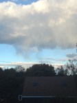
Here are some more pictures of the Virga here in Yarmouth.

Another chilly night is on the way so keep fragile plants indoors through tomorrow.

-Jack

Chilly Fall Day Today

Hello everyone! 

Today starts off chilly as just about everyone is below freezing and many are in the 20’s. Highs will rebound some but not much with upper 30’s north and mid 40’s south. Skies will be sunny for most though some afternoon clouds are likely north where upslope snow showers are also expected.

-Jack 

A nice cool fall day

Hello everyone! 

Another nice day on tap today with cool calm conditions expected. Highs look to range through the 50’s coolest north under mainly sunny skies south, mainly cloudy skies north.

-Jack