Today will feature mainly cloudy skies and some showers as a cold front rolls through. Expect highs to be seasonably warm again today around 60 south and low to mid 50’s north. Showers will be most likely in the mountains this morning though everyone is at risk for some raindrops through the afternoon.
Enjoy the warmth while it lasts, some snow is likely in the mountains this weekend with chilly temps everywhere.
Today will feature cool conditions with temps this morning starting off in the upper 20’s north and west and lower 30’s south and east. Temps recover reasonably but not crazily with highs expected to top out in the 50’s region wide closer to 50 north and closer to 60 south. Skies will feature a mix of sun and clouds with the scale tipping closer to clouds north and west.
Today will feature mainly cloudy conditions as a cold front approaches from the west. Out ahead of that cold front though temps will be pretty mild with highs ranging from the mid 50’s up north to the mid 60’s south. Some showers are possible in the mountains in association with the cold front but they will be hit or miss and not everyone is likely to get one. There is a better chance of precip the farther north you go.
Enjoy the warmth while it lasts, by the weekend we will likely be talking about snowflakes!
Today will feature showers possible in the morning with drizzle and fog likely as a storm passes offshore. A cold front will cross the area this afternoon bringing the chance for thunderstorms. Highs in the 60’s.
A pretty straightforward weather day today as high pressure remains just to our east and warm air funnels around the backside. Expect mainly sunny skies with highs in the upper 60’s north to mid 70’s south. This is likely the last time we get this warm until spring so enjoy!
Today will feature warmer conditions as high pressure slides east and winds turn Southwesterly. Expect mainly sunny skies with temps rising into the 60’s in most areas. Tomorrow looks just as nice but even warmer in the 70’s! For those warm lovers out there, cover your ears now because a pretty significant cold shot looks to end out the month and tomorrow is likely the last time we get this warm until Spring.
Back to straightforward weather today with chilly and breezy conditions expected. Highs look chilly in the 50’s under sunny skies and breezy winds. Winds will decrease as the day goes on.
It’s that time of year again – pumpkin everything, beautiful foliage, frolicking in the leaves, and of course the good old fashioned chilly rain. That’s what we get the pleasure of dealing with today.
8Z HRRR Model IDEA Of How Rain Evolves Over The Area Today. Credit: Weatherbell
Rain looks to overspread the area west to east this morning with everyone seeing raindrops by around 8:30 or 9 AM. Rain will be light to moderate for the most part but any southern areas that poke into the warm sector stand the chance for some thunderstorms and thus heavier rain. Gusty winds are also likely with this storm with the greatest risk south in any thunderstorms. Heavier downpours are the mirror mechanism that reflects the strong winds aloft down towards the surface so in any heavier showers region wide, gusty winds are a possibility.
A total of a half inch to an inch of rain is likely with the highest amounts up north on the south facing slopes. Winds could gust to 30mph in the strongest showers. Temps will be in the low to mid 50’s for most with areas south of Kittery seeing low to mid 60’s as they will be in the warm sector thus seeing the most rain.
Today will feature sunny skies, light but not nonexistent NW winds, and cool temps as high pressure remains in control. Expect highs ranging through the 50’s coolest north. Enjoy the nice weather because rain is incoming tomorrow.
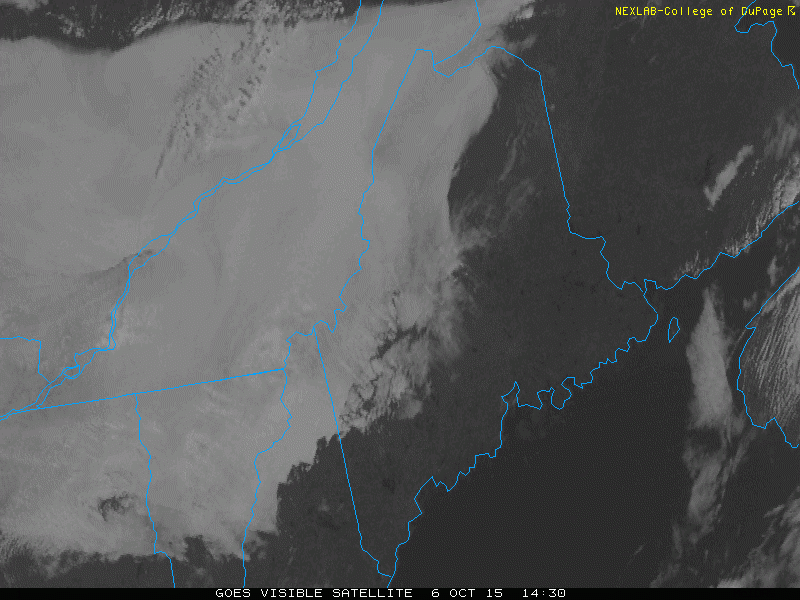
I tweeted yesterday about a neat weather phenomenon I saw on the visible satellite imagery yesterday afternoon featuring a low cloud dam built by the mountains.
Today the mesoscale effects of the mountains joined up to block low level moisture from pushing S pretty neat! #MEwxhttp://t.co/Q5i9QDZ2v9— Jack Sillin (@JackSillin) October 06, 2015
As you can see, areas NW of the mountains saw a dreary day due to low level moisture causing low clouds and fog depending on the elevation. Areas SE of the mountains though saw a stunning cloudless day. Why such a sharp contrast?
Moisture was limited to the very low levels of the atmosphere and when the moisture encountered the mountains, its instinct was to rise. It was able to do this somewhat but it was also limited in this endeavor due to a sharp low level inversion which put a strong cap on the ability of air to rise up and over the mountains. The morning weather balloon data from Gray showed this well.
12Z Weather Balloon Data From Gray Showing The Low Level Inversion
When the moisture found the mountains, it wanted to rise but couldn’t due to the inversion so as a result, most of the moisture was left stuck in place resulting in a dreary day NW of the mountains and a lovely day SE since the mountains blocked the moisture.
Here is a super awesome timelapse from the summit of Mt Washington showing the moisture trying to pass over the White mountains over in NH. Notice how the clouds are barely able to rise over the passes and how the inversion immediately shunts them down into the SE facing valleys where they sink and warm, thus dissipating and creating beautiful weather for most of ME and NH.
Even during times of relative quiet, New England weather never fails to impress!
Look up tonight to have a shot at seeing the northern lights as a moderately strong geomagnetic storm is ongoing at the moment. Best chance is in northern areas and everyone should look to the northern horizon for the best chance to catch a glimpse. While some clouds are likely to obscure viewing in NW areas, most of the area should have mainly clear skies.

 8Z HRRR Model IDEA Of How Rain Evolves Over The Area Today. Credit: Weatherbell