
Hello everyone!
A quick update tonight on the next messy storm in the lineup which arrives Wednesday. This one looks to be a fairly simple storm with mountain snow/mix, inland snow/mix/rain and coastal mix/rain. The challenge, as always, will be to pinpoint exactly where those transition spots will set up. The actual storm looks to track right over us and any nudge in the track would result in big changes to the forecast.

Low pressure that passed north of the region today left a cold front behind and that is currently sitting across the region this evening. Low pressure will develop along the front to our SW tomorrow and will move into our area overnight Wednesday. The low currently looks to track right over the area which means that we get the best of both worlds depending on location. The low passes south of the mountains so they get mainly snow with some respectable amounts possible especially the farther NW you go. The low looks to pass over the foothills so they get the full house of snow, sleet, ice, and rain. The low passes NW of the coast so they get the warm rain treatment. The exact lines between these zones are still blurry and will remain that way until things start playing out Wednesday morning.

The trick to this forecast will be temps aloft. The mid level low will track over the mountains which should let them stay mostly snow. Farther south, even the foothills are on the warm side of the low which means that the stage is set for mixed precip likely in the form of freezing rain. Significant accumulations are not expected but there will likely be widespread slick spots away from the coast Wednesday. Should the track of the mid level low shift to the north, even the mountains mix and less snow falls. If it shifts to the south, the mainly snow area could shift down towards the foothills. Both options are on the table at this point.
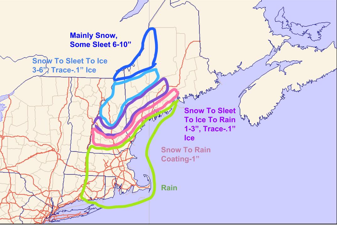
Here is what I’m thinking in terms of accumulation for various precip types. The only area that could get a significant storm looks to be the northern mountains. Everyone else mixes with an assortment of precip types.
A coastal storm misses south late week and then a ridge builds into the east coast which leaves us with building heat heading into next week.
Next winter will be better.
-Jack
