A Temperate Rest Between Snows

Hello everyone!

Today will feature temperate conditions, not too cold, not too warm, just right. Look for mainly sunny skies with the exception being the mountains where a few more clouds are possible. Highs will rise into the upper 20’s north and low to maybe even mid 30’s south. All in all, a lovely day for cleaning up after yesterday’s storm.

Ready for more storminess? We have not one, not two, but three threats for substantial snow in the coming week and each is likely to bring at least light snow. I’ll have more updates on each threat (Monday, Tuesday/Wednesday, and Friday) as they become clearer.

-Jack

Snow Arrives This Morning, Continues This Afternoon

Hello everyone!

Light rain is currently moving into the area and will quickly change to snow this morning as temps crash. Temps are currently in the mid to upper 30’s however Dew Points are in the mid to upper 20’s. As precip begins to fall, the air becomes saturated and the temperature crashes to the Dew Point. In case that was a little too technical, when the precip starts, the temp falls.

hrrr_2016020508_ref_15min_neng

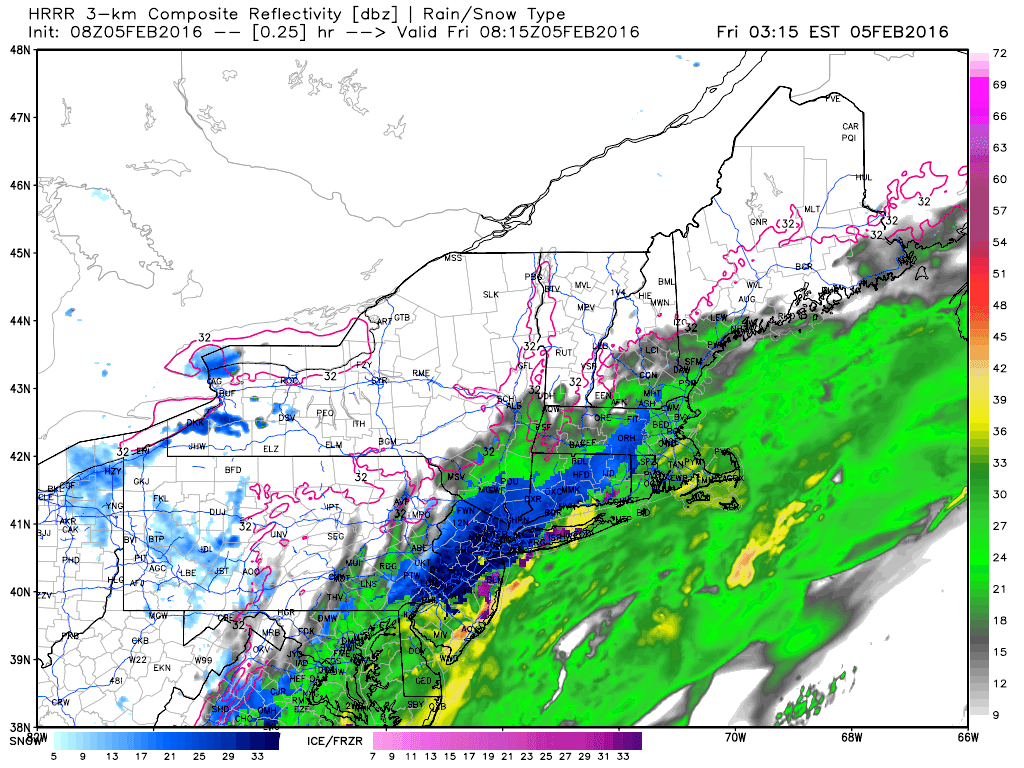
This is the HRRR model showing the evolution of the storm from light rain  this morning through heavy snow later this morning through the early afternoon and then light snow tapering to flurries by early evening. Credit: Weatherbell.

Temps will be on the warm side today, generally in the low 30’s so this will be a heavy, wet snow. Winds could kick up a bit this afternoon so a scattered power outage or two wouldn’t be shocking though I think that risk is low.

2016-02-05_6-12-05

In terms of amounts, look for 3-6″ along the coast with 4-8″ along the midcoast. The foothills likely see 2-4″ with the mountains getting only a coating-2″.

Snow tapers off this evening setting the stage for cooler air tomorrow. An arctic front blasts through on Sunday which sets up a potentially significant storm early next week. I’ll have more on that as we get closer.

-Jack

Sneaky Snow Event Tomorrow

Hello everyone!

As much as I would LOVE to have a full blog update out right now, school commitments got in the way. In place of the normal update, I did a video update which you can find below. I’ll have a full update tomorrow morning as it would’ve normally appeared tonight. Please watch through to the end for accumulations, I want to explain the factors and the setup before I explain accumulations.

-Jack

Warmth Sticks Around Today One Last Time

Hello everyone!

Today will feature spring’s last stand (for now) as a cold front moves offshore. Behind the front, winds will turn westerly and downslope off the mountains leading to warming temps and sunny skies (for more on that, check out my article in the December issue of UpPortland). Look for highs in the 50’s south and 40’s north. An ocean storm develops to our south and moves NE tonight bringing a period of light to moderate snow at the coast, especially the farther east you go towards the midcoast. A general coating-2″ is expected along the coast with an isolated 3″ amount possible in the Camden Hills.

Cold air and many a storm threat arrive next week, this is winter after all!

-Jack

Warm, Windy, And Rainy Today With A Dash Of Winter Up North

Hello everyone!

Today will feature rain for most, especially SE, while northern areas see a mix of snow, sleet, and freezing rain before switching briefly to rain. Highs down south will rise into the 40’s to near 50 while highs in the north will remain trapped around 35. Snow near Sugarloaf could accumulate to around 6″ with lesser amounts to the south. Up to a quarter inch of freezing rain is also possible before brief rain. Down south, everything looks to fall as rain with a half to one and a half inches expected.

Don’t worry winter lovers, this is the slightly misplaced vanguard for what looks to be a sizeable arctic assault next week. This is winter in Maine after all!

-Jack

Just A Bit Cooler Today

Hello everyone!

Today will feature partly to mainly sunny skies along with slightly cooler temps. Look for highs in the upper 30’s to low 40’s with the chance for a stray mountain flurry. There will be more clouds up north and thus temps look a bit cooler, in the low to mid 30’s.

-Jack

Toasty Today

Hello everyone!

Low pressure will pass to our west today and that will leave us on the warm side of things as warm air drives northward on southerly winds. Look for a mix of sun and clouds with morning lows in the 30’s rebounding into the 40’s north and low 50’s south. Light precip this morning could fall into pockets of subfreezing air in the foothills and mountains so watch for isolated slick spots there.

-Jack