Morning clouds and showers are giving way to party to mostly cloudy skies with some sun possible especially along the coast by this afternoon. Gusty NW downsloping winds will aid in clearing out the coast. This sun will destabilize the atmosphere enough to allow for some popup shower activity this evening along the coast with a rumble of thunder and a few small hailstones possible. Highs will be cooler, in the 40’s north and low 50’s south.
Clouds make a comeback today along with some showers, especially in the afternoon hours. Look for temps to be a bit cooler, mainly in the upper 50’s to low 60’s south and upper 40’s to low 50’s north. Chances for precip increase through the day and most should see a drop or two by sundown. Steady rain arrives overnight but should be mainly gone by tomorrow morning.
Today will feature warm temps, light winds, and sunny skies as high pressure builds in. Look for temps to rise into the 60’s for most with low 70’s in southern areas away from the coast where a sea breeze will likely develop this afternoon.
Weather wise, yesterday is forecast to happen again today with temps rising into the 50’s and low 60’s under sunny skies and moderate northerly winds. This combo will again lead to enhanced fire danger so please be cautious of that. We had two fairly large wildfires in Maine yesterday that threatened houses so lets not repeat that if we can. Thankfully, I do not believe anyone was hurt yesterday. A Fire Weather Warning (Red Flag Warning) is up for coastal areas again today due to this threat.
Apologies for no post yesterday morning, I had one all written out but the whole posting part seemed not to work out too well in the mind of the computer. In any case, if you remember yesterday’s weather, than you know the forecast for today with just a few changes. The most noticeable will be the winds which will be fairly significant today, gusting to near 30 mph along the midcoast and 25 mph farther west. The warm, dry, and windy conditions are exceedingly favorable for wildfires and a red flag warning is up for areas outside of the mountains today. Try not to set anything on fire if you can help it. Temps rise into the low 50’s north and mid 50’s south and will be a degree or two above yesterday’s highs.
The cold front that brought rain yesterday is now well offshore leaving cool and dry conditions in place for today. Highs will get up into the low 40’s north and upper 40’s to low 50’s south. Sunny skies will dominate today as light NW breezes continue to dry the air.
Along with increasing temps comes increasing rain chances and increasing SW breezes both of which will be on display today. Expect dry conditions this morning to give way to rain on and off through the day. Rain should be moving out by the mid afternoon hours from NW to SE. SW winds are likely to gust over 20mph. Temps rise into the mid to upper 40’s north and mid to upper 50’s south.
Many are seeing snowflakes this morning as warm air moves in aloft. This will continue through the early to mid morning hours before tapering off and changing to rain. Rain showers will be on and off today. While it won’t be a deluge, most everyone should see some drops at some point. Temps start out in the low 30’s this morning and will slowly be climbing into the mid/upper 40’s by this evening. Some areas in far SW ME could touch 50 this evening.
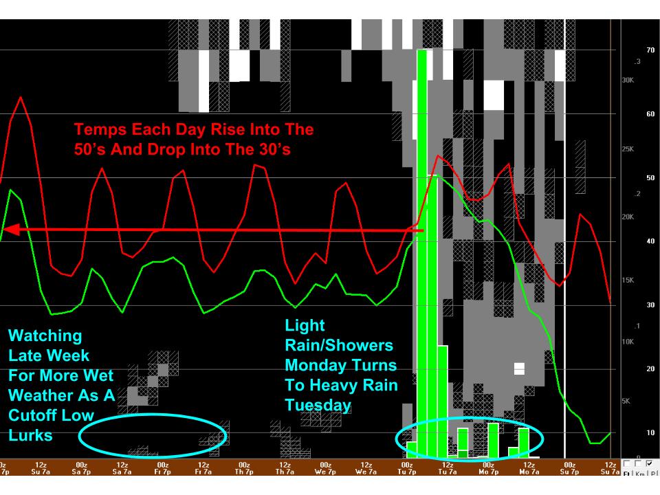
Here’s a quick look at the upcoming week of weather for Southern/Western Maine. Unfortunately I don’t have the time to fully dive into all the cool weather this week but here’s the quick overview to give an idea of what’s to come.
The week likely is bookended by rain events, one coming tomorrow into Tuesday and the other Friday-TBD. The late week rain is brought to you by a cutoff retrograding low. This means that it is cut off from the westerly winds aloft that usually push storms along quickly. The long and the short of it is that after a dry and pleasant midweek, the late week period into next weekend looks wet and cool as low pressure lingers nearby. The GFS model I use for these graphics holds the low just offshore but based on the block over Greenland, I think we get at least some rain from this. More updates (hopefully, depending on the schedule) this week.
Today will feature mainly sunny skies, calming winds, and cool temps. Highs climb into the 30’s north and low 40’s south today under mainly sunny skies though a few high clouds could work in toward the evening hours. Wet weather arrives tomorrow.