
Hello everyone!
All our players are in place for a moderate snow event for most of the area tomorrow. Snow is already falling across SW NH, as was forecast last evening, and is making slow but steady progress NE. By midnight, everyone in the area should be seeing flakes (or raindrops along the York County coastline, far SE NH, and the tips of the midcoast peninsulas) with snow beginning in the Portland area around or a little after 9.

We have all the players on the field so to speak with cold air streaming south out of the north ahead of the storm. Our primary low is dissipating over the Great Lakes while the secondary low begins to emerge over northern Virginia. As the secondary low slides ENE, the coastal front along the ME and NH coastlines will sharpen up, changing any raindrops at the onset over to flakes fairly quickly. Wet bulbing will also help with this as latent heat energy is lost from the atmosphere during evaporation. Notice also the relatively warm airmass following the storm. This is part of the ‘winter halftime’ and while temps for most will be below freezing, there’s no punishing cold behind this system. We’ll save that for the pattern change that’s been widely advertised for February. I talked a little about that last evening.

Here’s a visualization of that coastal front. Warm marine air will attempt to push inland and will run into strong cold air damming associated with high pressure to the north. This high will feed cold air south and will be the driving force behind the mainly snow nature of this event. The exact placement of the front will determine who sees rain and who sees snow but I think the model has a pretty good handle on its placement. The NH seacoast, the coastline of York County, and the tips of the Midcoast peninsulas will be at greatest risk for raindrops though some snow accumulation is likely there too.

The other important factor the coastal front brings to the table is a focus for lift and enhancement of precip. The warm marine air being forced to rise over the low-level cold dome will produce lift and will help to wring out the moisture in an otherwise weak system. In terms of overall QPF (quantitative precipitation forecast), about .5 to .75″ of liquid is expected across most of SW ME (areas in blue are where the model thinks >.5″ will fall). Farther NE, amounts will drop off as less moisture is available. How much snow does that equate to? The answer will lie in the snow to liquid ratios, to be determined by lift and moisture within the dendritic growth zone.

Note the two different areas of lift in the vertical profile of upward motion (z component to the wind). The component that will produce the best snow growth will be associated with a burst of warm air advection in the mid levels. This is a process driven by the weakening primary low and thus won’t be super strong. The stronger lift will be closer to the surface and driven more by the coastal front dynamics. This process will not be co-located with the DGZ. As a result of the modest snow growth and fairly warm surface/near surface temps (just below freezing), look for this to be a heavier/wetter low ratio snow rather than the fluffy stuff that piles up much more efficiently. Look for snow:water ratios of right around 10:1 compared to the usual 12:1 or the fluffy 20:1 we sometimes see.

Here’s the latest snowfall forecast. Most areas will see 3-6″ with rain holding down accumulations along the seacoast of NH, coastal York County, and the midcoast peninsula tips. A lack of lift/moisture will keep accumulations down to the NE while the jackpot is likely to be across NH and extreme western Maine.

Here’s a look at how things evolve tonight and tomorrow. Snow will be light to moderate for most and will taper off to flurries for most by tomorrow mid morning. The steadier snow will hang on the longest at the coast where the coastal front will continue to enhance lift as discussed above. After the snow moves out mid day, residual moisture in the low levels will create a freezing drizzle hazard through the evening hours. As a result, use caution traveling tomorrow even if the flakes aren’t actively falling.
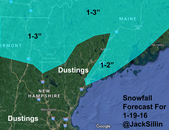
More snow is expected as a disturbance passes overhead Thursday morning. The best chance for a couple of inches will be in the mountains though some ocean moisture could enhance things just enough along the coast to squeeze out an inch or two. The rest of the area will see flurries with a dusting possible.
More precip is likely by the time we get to the upcoming weekend but it’s too soon to say if we’ll see rain, snow, or a mix of both.
-Jack

