Today will feature some classic tundra weather (the motto for this week’s weather) as low pressure develops well offshore. Some coastal flurries are possible this morning so don’t be shocked if a few flakes are drifting down this morning but any accumulation will be limited to a very light dusting and most areas won’t even see that. Skies will feature more clouds than sun in the morning and more sun than clouds in the afternoon as north winds pick up. Gusts to 20mph are possible out of the north this afternoon which will make chilly temps feel even chillier. As far as temps go, look for highs ranging from 15 in the north to 25 along the coast.
More flurries are possible Saturday night with another coastal storm that just grazes us with the fringe of its fury.
Today will feature mainly sunny skies along with gusty NW winds and falling temps. What you step outside to this morning is likely the warmest temp you’ll feel for the day as much colder air is flooding in from Canada. Along with the colder temps, you’ll notice gusty winds which will make the chill feel even chillier. Temps are beginning in the low 20’s north and upper 20’s south this morning and will be falling to the low 10’s north and upper 10’s south by nightfall. NW winds will be gusting to 25/30 mph. No precip is forecast though snow showers in the favored upslope regions can’t be ruled out.
For more details on the upcoming week of weather, check out last evening’s post.
With all the chatter out there about a storm this weekend, I wanted to give a quick fact based, no-nonsense rundown and analysis of the potential snow event. There certainly is potential for some flakes to fly but several notable inhibitors will likely prevent a major storm. I also wanted to highlight the pattern for the coming week or so which will feature “tundra weather” aka cold and dry.
18Z NAM Showing Coastal Flurries Friday Morning. Image Credit: Weatherbell
Our first chance for flakes will be Friday morning as a storm zooms by offshore. Only the coast will be at risk for some flurries which won’t amount to more than a dusting. Any steadier snow will be limited to SE MA, RI, SE CT, and E LI. The mountains of our area will remain dry. The best shot for some coastal flakes will be from 6-11 AM Friday morning with snow lasting a little longer in the aforementioned areas of SNE.
12Z GFS Upper Level Energy Map For Friday Midday. Image Credit: Accuweather
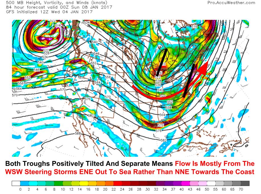
This storm will be weak and remain well to our SE because of the orientation of the 500mb trough. Notice that the trough is shallow, weak, and positively tilted (from NE to SW). This means that the dominant steering winds are from the WSW which will understandably keep the storm moving ENE. Also notice the two disturbances highlighted back to the west. These are the building blocks of any potential weekend storm and their interactions will determine whether the coast will see a plowable snowfall or if we remain locked in the cold, dry pattern that arrives after tonight’s cold front.
12Z GFS Upper Level Energy Map Showing Why The Storm Is Likely To Remain Mostly OTS. Image Credit: Accuweather
There is continued disagreement among model guidance regarding the interaction of the two disturbances. The GFS shown to the left keeps both systems separate and positively tilted. This means that the situation would be setup similarly to the event Friday morning with limited impacts. The Euro digs the steering disturbance (the one farther NW over the Great Lakes) deeper and phases both disturbances into one system that turns negatively tilted. This would result in a more significant storm capable of bringing plowable snow to the coast.
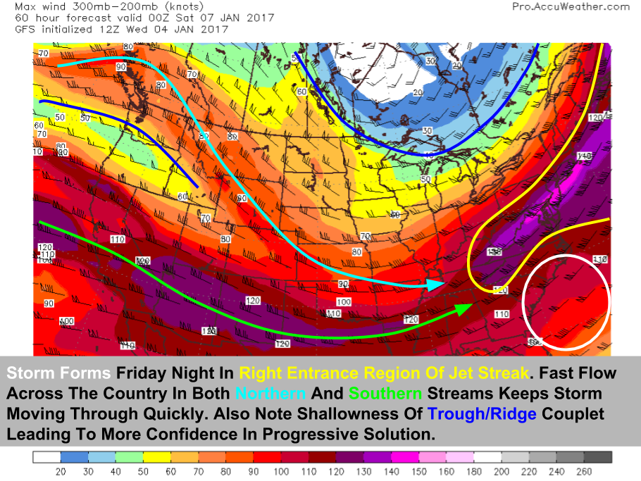
12Z GFS Jet Stream Map Showing A Setup Not Conducive For A Large Storm. Image Credit: Accuweather
Looking at the jet stream, the setup in the upper levels continues to point towards a weaker system that slides farther east. Notice the low amplitude (flat) flow with only a very shallow ridge over the west coast and trough over Hudson Bay. Our storm will be developing in a favorable right entrance region but it will be embedded in extremely fast flow moving across the country. It also won’t have the benefit of a coupled jet streak setup where the left exit region of one jet overlaps with the right entrance of another.
12Z GFS Showing Cold And Mostly Dry Weather For The Upcoming Week
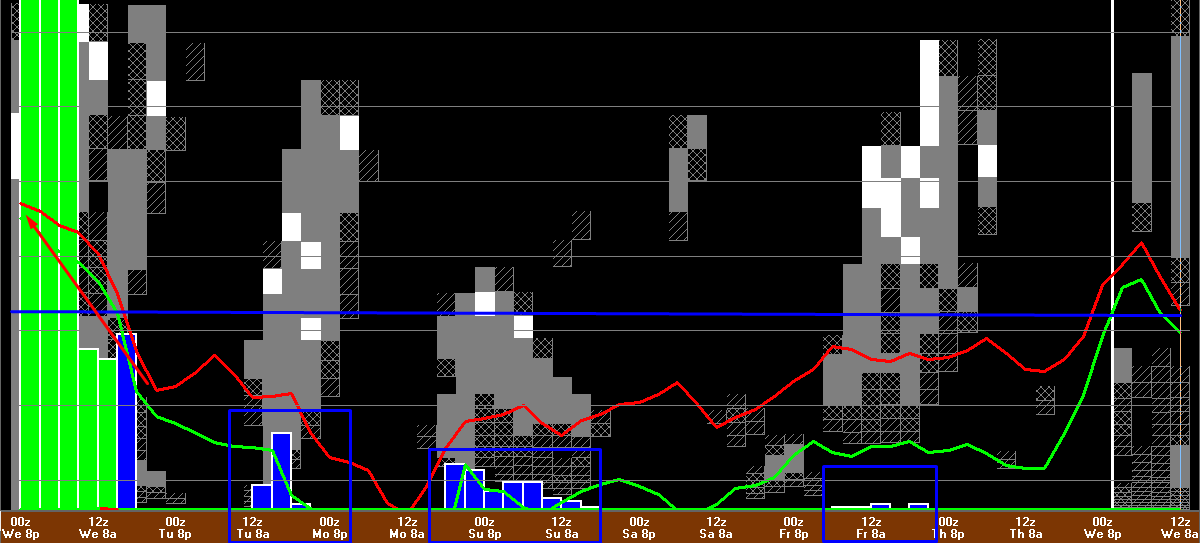
Taking a quick look at the next 7 days, you can see how the term “tundra weather” would be apt. Temps will fall below freezing tonight and likely won’t rise back up to that mark until a week from today at the earliest. This graph is for Portland so expect that temps inland will be even colder and in the mountains, the next thaw might not be for several weeks as Arctic high pressure systems are only briefly punctuated by warmer clipper systems.
12Z GEM Showing A Weak Clipper Approaching The Region Monday Evening. Credit: Weatherbell
Our next chance for snow looks like a clipper sometime on Monday or Tuesday. After that, any details are lost to the mists of time but signals are showing up for an inland runner type system in roughly a week’s time. In the meantime, bundle up and throw some sand on that driveway because any ice tomorrow morning isn’t likely to melt off in a hurry!
Today will feature mainly cloudy skies along with morning precip and mild temps. Inland areas are still below freezing so this morning’s precipitation is likely of the sleet/freezing rain variety. Precip will move out later this morning and will leave mainly cloudy skies for the rest of the day. Despite the clouds, temps will be fairly mild with highs in the mid 30’s for most, upper 30’s along the coast. Some breaks of sun are possible in NH/far W ME before sundown but they will be fleeting. Sunnier but cooler weather is in store for tomorrow.
Freezing drizzle is already falling across parts of the area with some snow showers up in the northern mountains. This is part of a strong cold air damming event that is now ongoing. Mixed precip will continue through the day with very slick roads expected to develop especially away from the immediate coast. Precip for most of the day will be light but this evening steadier precip will arrive and by tonight, some heavier bands could develop as low pressure develops offshore.
The mountains will see snow occasionally mixing with sleet today accumulating 4-8″. Temps will be in the 20’s.
The foothills will see a mix of snow/sleet/freezing rain with 2-4″ of snow and a glaze to a quarter inch of ice in the most sheltered valleys. Temps in the 20’s to low 30’s.
The coastal plain will see mainly freezing rain with a coating-2″ of snow possible and up to a tenth of an inch of ice. Temps 28-32.
The immediate coast will see freezing rain changing to plain rain with a glaze of ice possible. Temps 30-35.
Colder and drier weather looks to follow this system for a while.
Today will feature mainly sunny skies along with mild temps and light winds as high pressure builds in right overhead. Other than a few afternoon or evening clouds, expect plenty of sunshine today with mild temps topping out a little below freezing in the north and a little above freezing in the south. No precip is expected through this evening as tomorrow’s storm remains well SW of the region. Winds will be light as high pressure builds overhead.
Tomorrow will feature the return of wintry precipitation in various forms with snow, sleet, freezing rain, and rain expected for different parts of the area. For all the details on this, click on over to last evening’s update where I outline the setup and potential impacts. Depending on my schedule today, I may have another update this evening.
With the new year comes new opportunities for interesting weather here in Maine and no time will be wasted in setting up an interesting pattern to start off the incoming year. The main event this post will focus on will be a mixed precipitation event forecast to move into the area Tuesday. Low pressure will approach from the west while high pressure will dig in to the NE. To add some extra fun to the mix, coastal low pressure is forecast to develop as energy is transferred across the Appalachians which will drag in colder air and possibly introduce some heavy precip Tuesday night into Wednesday morning.
500mb Analysis Shows Large Scale Pattern Ripe For Cold Air To Move South Across North America. Image Credit: University of Wyoming
To understand the weather in our corner of the world, you often need to zoom out. A lot. This is why I’ll begin with the entire northern hemisphere. The pattern is set up for cold air to move south due to high latitude blocking over the North Pacific and the North Atlantic. This means that the bubble of cold air surrounding the north pole is being pinched (think of pressing in on a balloon from opposite sides). When the cold pool is pinched, parts of it are forced to spill south and that is exactly what we’re seeing with a pocket of cold air centered over James Bay, Canada. This combined with tonight’s cold front and attendant shortwave energy (little wiggle in lines near New England) means that cold air will be in place in advance of our next storm system.
18Z GFS Showing Very Cold Air In Place Tuesday Morning. Credit: Weatherbell
Sure enough, model data shows the cold locked in Tuesday morning. Notice the subzero temps inland and the sharp gradient associated with a coastal front. Remember the last time we had a sharp coastal front set up ahead of a developing coastal storm? I strongly believe that all model guidance warms temps too quickly during the day on Tuesday. While the immediate shorelines are likely to go above freezing before substantial precip arrives, anyone NW of route 1 needs to expect a period of mixed precipitation Tuesday night.
12Z GEFS Showing The Setup For Tuesday’s Event. Image Credit: Weatherbell
Here’s the synoptic scale setup early Tuesday afternoon as precip begins to arrive in the area. Cold high pressure is locked in over Quebec (not over Bermuda like other recent events) and a storm is transferring its energy across the Appalachian mountains to secondary low pressure off the Mid Atlantic coast. This setup screams Cold Air Damming that lasts. Other events have lacked the big cold high to the north and the coastal redevelopment. For more on how CAD works, check out one of last winter’s UpPortland columns that explains how that works.
18Z 3km NAM Showing Mixed Precip Impacting The Area Tuesday Night. Image Credit: Tropical Tidbits
Now that we know the Hemispheric scale pattern, and the synoptic scale pattern across the entire east coast, let’s focus in on New England for the mesoscale patterns. High res guidance does show mixed precip over the mountains Tuesday night but I believe the rain/mix line will be considerably farther SE than modeled. You can see the difference in the graphic. This line will begin moving SE as the developing coastal storm draws in colder air. Some bands of heavier precip may develop and act to speed cooling but the dynamics that we enjoyed Thursday night are not likely to be present with this event. This is due to the fact that the energy aloft for this upcoming event will be nowhere near as strong as it was on Thursday. Despite that, the low is forecast to deepen at a reasonably quick rate and thus we will have to worry about the possibility of some heavier bands working in early Wednesday morning.
12Z GFS Showing A Moderately Supportive Upper Air Pattern Tuesday Night. Image Credit: Accuweather
The upper air situation will not be conducive for explosive deepening of the coastal low. The northern and southern stream disturbances will remain separate and unphased meaning that they can’t join forces to become a powerful storm like Thursday night. We also will get the pleasure of dealing with the southern disturbance which is the one with the warmth and the moisture and being more or less cut off from the northern disturbance which has the cold air supply. Despite this, some cold will be around before the storm as we saw with the temps Tuesday morning and that cold will likely hang around long enough to cause some issues inland.
My Forecast For Precipitation Type Tuesday Night Into Wednesday Morning.
Here’s what I think will be falling from the sky Tuesday afternoon through Wednesday morning. Almost everyone will see some frozen precipitation at the beginning and after a fairly short period of time, the immediate coast and CT river valley are likely to go over to rain. Most of the coastal plain will continue as freezing rain for much of the event while the mountains start and end with some snow. Exact accumulations are still uncertain but snowfall is unlikely to exceed 6″ even in the northernmost mountain towns. Ice amounts could get close to .25″ in the typical foothill areas that keep the ice around longer but most areas will see between a trace and .1″ of ice.
Precip moves out Wednesday morning before colder air invades for the second half of the week. Threats of a coastal storm late week appear to have diminished as the pattern becomes less amplified though it’s still worth keeping an eye on if you have plans for Friday as the low could easily drift back in our direction.
Last night’s rain and snow is on its way out and will be replaced by milder and sunnier weather for the daylight hours today. Look for clearing skies outside of the mountains where snow showers and squalls are ongoing this morning. A few flurries could make it to the coast but any quick coatings will be limited to the foothills and mountains. Those squalls will dry up this afternoon and clouds will eventually break up in the mountains by sundown as high pressure builds in. Temps will range from 30 in the north to 40 along the coast with light westerly winds.
A plethora of precip types will return for Tuesday with snow, rain, sleet, and ice all likely to be seen somewhere in the region by the time the storm moves out Wednesday. More details on that as we know more in the next day or two.