Today will feature the beginning of the 7th inning stretch of our winter. We’ve had lots of fun and there’s more to come, but we’re taking a break before the final push. We have about a week of mild and calm weather ahead before winter’s final push in early March. Today will feature partly to mostly sunny skies along with a NW breeze and dry conditions. Look for highs in the mid 20’s north and low to mid 30’s at the coast.
Dry and warm weather will continue through the weekend.
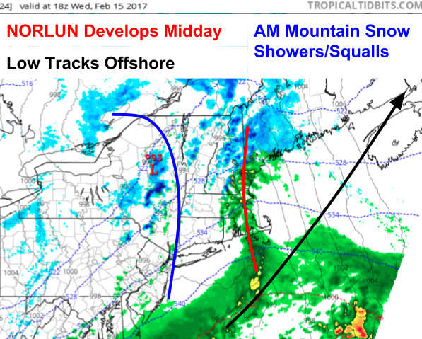
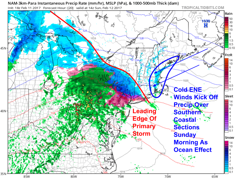
Our next storm is already here across the mountains this morning as low pressure approaches from the west. Look for snow to continue through the day in the mountains while a mix of snow and rain develops towards the coast. Temps will range from the 20’s up north to the 30’s along the coast. Temps fall this evening and change everyone over to snow which is likely to be heavy at times as a Norlun trough combines with a storm offshore to bring intense bands of snow to the area.
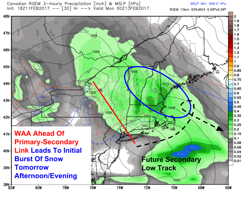
More snow is on the way! A clipper system will approach the region tonight before capturing and pulling a storm from the SE US up the coast in our direction. Precip will start tomorrow morning in the form of snow across the mountains. As the cold front associated with the clipper approaches, some of that snow may be squally in nature. Then, the real fun begins tomorrow mid day as a norlun trough sets up in SW Maine. Moisture will be funneled west along this trough and it will produce a band of very heavy snow. As the coastal low pressure system develops offshore, more bands of heavy snow could rotate into the region before the storm moves offshore Thursday morning.
18Z 3km NAM Showing Our System Getting Into Place Tomorrow Mid Day. Image Credit: Tropical Tidbits
Here’s a look at one model’s depiction of the weather map tomorrow afternoon at 1 PM. Note the Norlun trough developing along the New England coastline as moisture from the offshore storm is funneled back into the region. This process is a sure bet, where exactly it sets up and what the temperature is along the coast while it’s going on isn’t. Right now it looks like locations near Portland will start with a light rain/snow mix before going over to snow in the early evening. Exactly when this transition happens will be crucial in determining how much snow falls.
18Z NAM Showing Upper Level Dynamics Favorable For A Storm. Image Credit: Accuweather
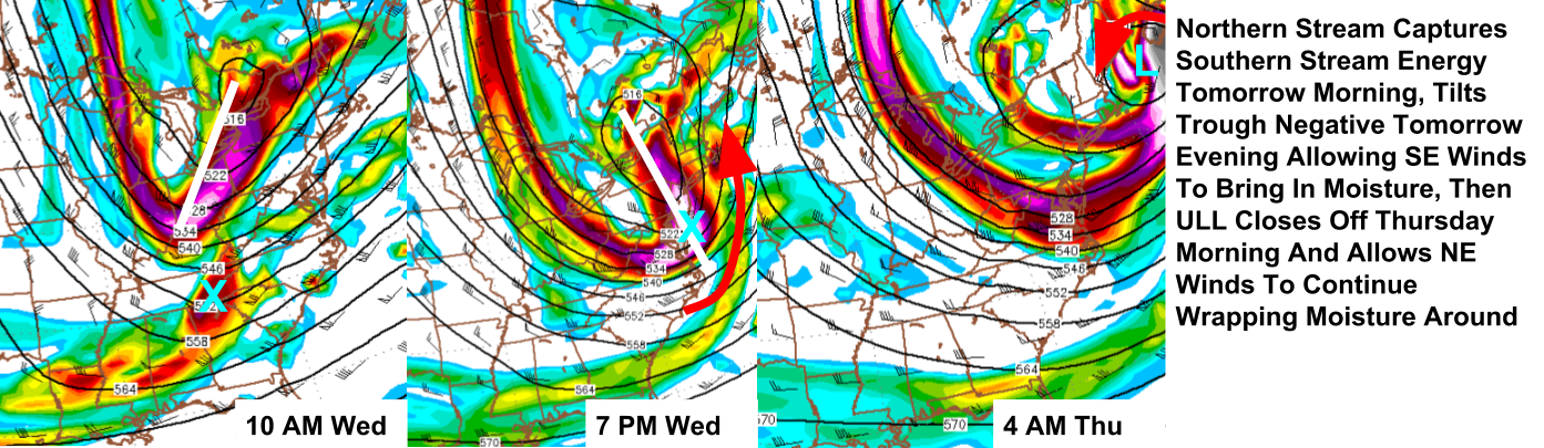
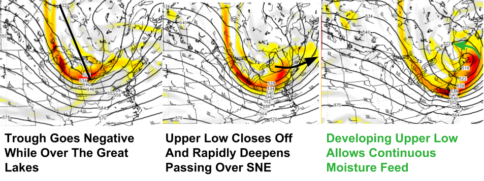
The Norlun trough will then become just another band on the west side of a coastal low due to upper level dynamics favorable for cyclogenesis offshore. A trough is diving SE out of the Great Lakes this evening and will ingest a disturbance currently moving through Oklahoma. The OK disturbance will tilt the trough negative tomorrow evening allowing for moisture to stream into the region. The upper level low will then close off to our south helping to keep precip going by wrapping in moisture and precip from the NE.
18Z NAM Showing Marginal Temps As Precip Arrives Tomorrow Afternoon. Image Credit: Weatherbell
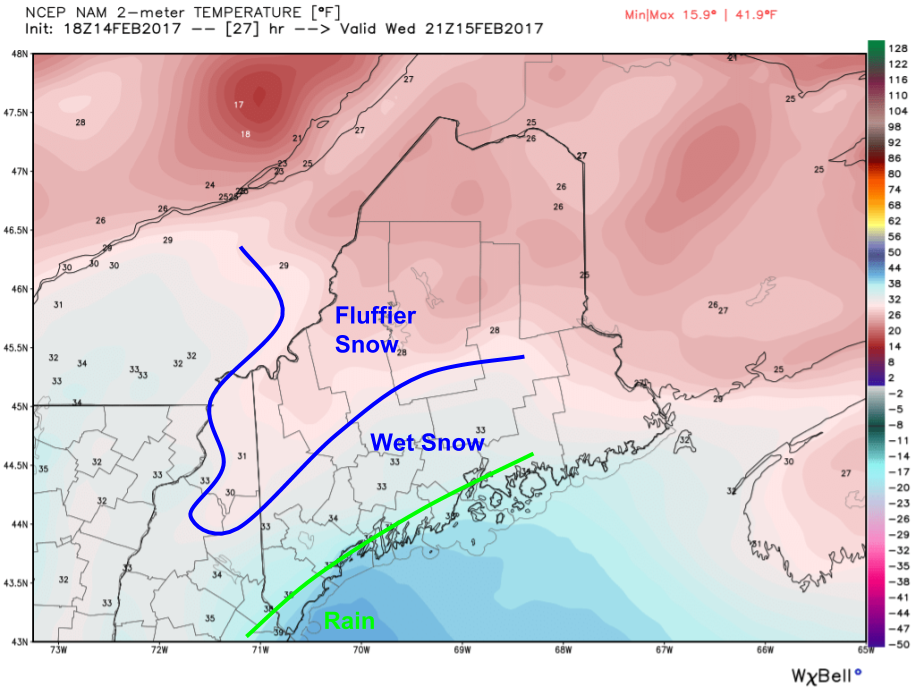
As precip gets going tomorrow afternoon, the biggest limiting factor will be surface temps. In the mountains, things will be plenty cold enough for a fluffy snow. More pow for the ski areas! Along the immediate coast, precip will start as rain. In between, a wet snow will fall. Exactly where the rain/snow line sets up and how fast it collapses SE will determine if the coast gets 6 or 16″ of snow. Any coastal rain will quickly turn to snow as cold air moves in later in the evening tomorrow.
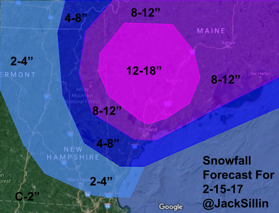
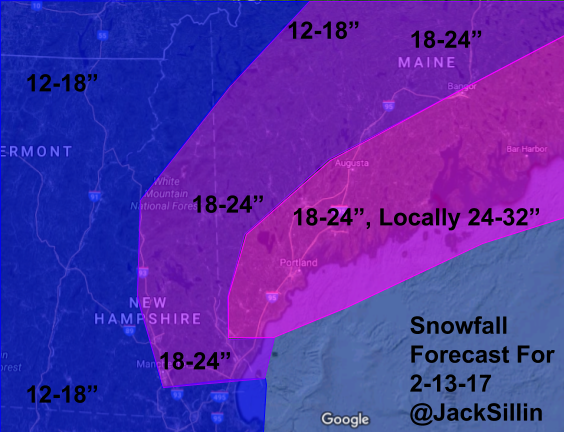
Snowfall Forecast Through Thursday Afternoon
Here’s what I’m thinking with regards to snowfall amounts. There will be a sharp gradient in NH as it’s a little uncertain how far west the heavier bands get. I’ll update this tomorrow when I know more. The snow in the mountains will be of the fluffy variety and of the wet/heavy along the coast. With all the recent snow, be mindful that loads on roofs will be getting very heavy so be sure to clear off as much as you can!
If you’re getting annoyed at this pattern, do know that a thaw is coming next week. If that thought makes you sad, winter will likely return to kick off March.
Today will feature quiet weather as high pressure builds overhead. Look for a mix of sun and clouds, light winds, and dry conditions. Temps will rise into the mid 20’s north and the low 30’s south. We have one more storm in the pipeline tomorrow into Thursday before we’re back to January’s mild and boring pattern.
Our blizzard is here and ongoing across Maine this morning. Precip has moved out of western NH but is still going strong over ME as bands rotate in around our ocean storm. Winds are only beginning to wind up as our storm intensifies so expect continuing deterioration of visibility even as snow begins to lighten up. From the looks of it, an additional 4-8″ can be expected from Portland to Augusta and points NE. 2-4″ more is likely from Kittery-Fryeburg and NE while NH is likely only to see another coating-2″ on top of what’s already fallen. Winds will gust in the 40-50mph+ range along the coast and in the 20-40mph range inland which will blow around all the light/fluffy snow resulting in very low visibility. Winds could also be enough to bring down some trees which could result in power outages.
HRRR Model Showing Heavy Snow Departing Today. Credit: Weatherbell
Snow will wind down from W to E during the day with snow already nearly done in the CT river valley and snow continuing into the early evening along the midcoast. The HRRR Model shown above gives a good visualization of this trend. Temps will linger in the 20’s for most today as daytime heating is balanced out by colder air being drawn into the storm from the north.
More snow is possible Wednesday into Thursday with some folks likely seeing another foot and possibly more. More details forthcoming!
We are all systems go for a major blizzard tonight and into tomorrow morning. Low pressure now forming S of Washington DC will move NE over Cape Cod and into the Gulf of Maine by early tomorrow morning. As it does this, a powerful upper level disturbance will drive explosive development of the storm, pulling it west and stalling it out for a brief time tomorrow morning over the Gulf of Maine. The storm will then slide SE offshore tomorrow during the day. Now that snow is beginning to fall over NH and SW ME, we can rely less on model guidance and more on observations to determine if we need to change the forecast at all.
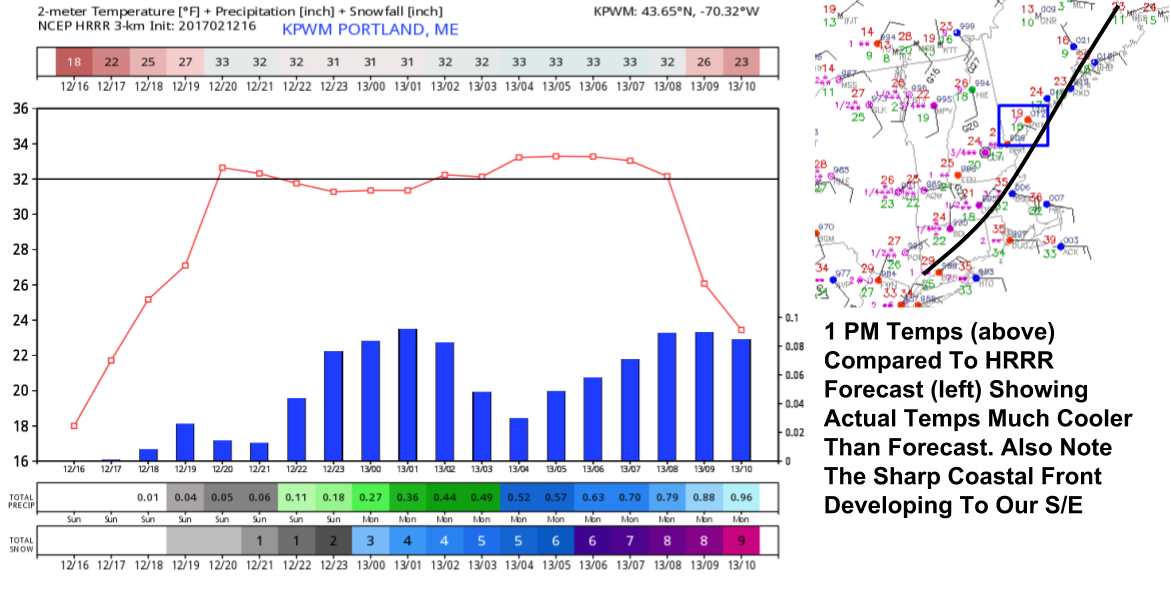
1 PM Verification Of HRRR Model For Temps In PWM. Images From Weatherbell And Aviation Weather Center.
Model guidance has pretty much locked in the amount of liquid equivalent that will fall (around an inch in the mountains and between 1.5 and 2″ along the coast) so now the snow forecast goes over to ratios. Will the snow pile up quickly with very high snow:liquid ratios or will it be sludge that hardly accumulates at all with low snow to liquid ratios? Given strong snow growth dynamics (see last night’s post), this will largely come down to surface temps. As the above image shows, temps are currently well below model forecasts across the coasts (by around 5 degrees) meaning that a drier, fluffier snow is looking likely.
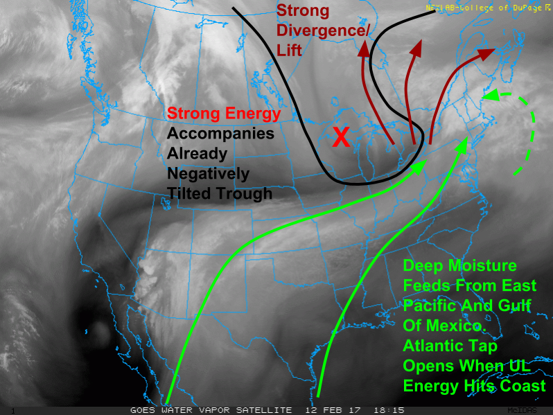
WV Satellite Imagery Showing Everything Coming Together For A Major Snowstorm. Image Credit: COD
In the upper levels, the water vapor satellite tells the story. Powerful energy is racing SE across the Great Lakes with abundant lift and moisture ahead of it. As soon as that upper level energy hits the coast, the storm will explode and snow will intensify as moisture is dawn in from the Atlantic. The upper level trough is already weakly negative and well on its way to becoming very negative as the energy works east. This is the mechanism behind the explosive strengthening of our storm.
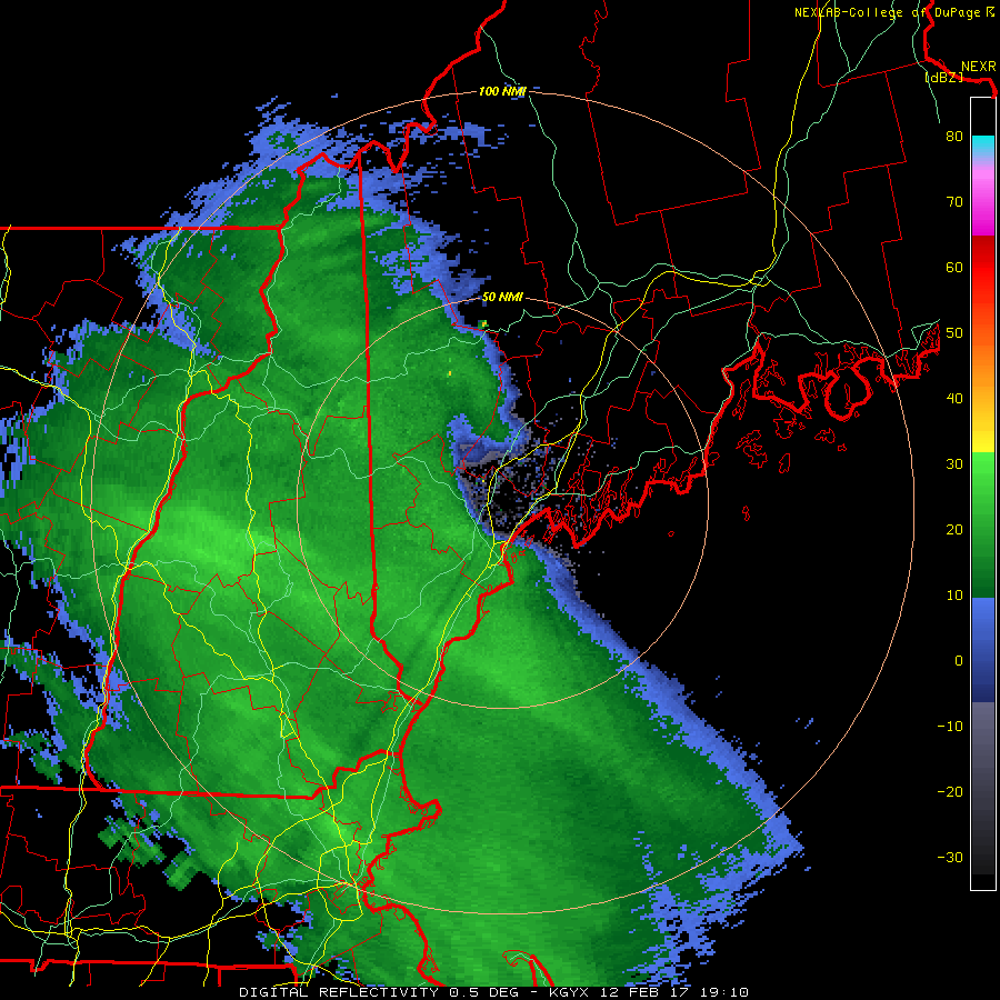
Radar this afternoon is showing bands of moderate snow working into the area from SW to NE. These will eventually overspread the entire area this evening and will continue through the overnight hours. During that time, the storm offshore will really get going and bands of snow will begin moving in off the ocean. As the storm stalls and slides out to sea, those bands will stall and then collapse SE with it. Where exactly these bands stall out tomorrow morning will determine who gets the jackpot totals. Under the heaviest bands, 30″ totals are a distinct possibility though only a few towns will see those so the general 18-24″ forecast stands.
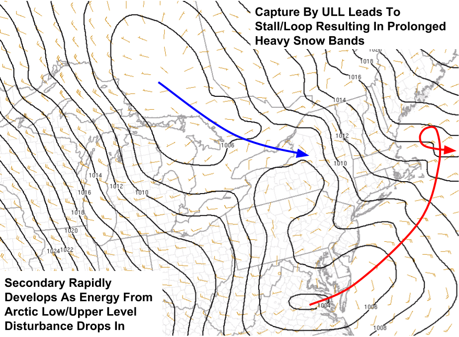
Surface Map Showing Low Pressure Just Developing Over Virginia. Image Credit: SPC
Here’s the surface analysis from 2 PM this afternoon showing our storm beginning as a benign 1004mb low pressure system embedded within 80F temps in Virginia. From its humble origins, it will turn into an all out blizzard as it loops off the MA coast tomorrow morning. This loop/stall will be a result of the upper level low capturing the storm and pulling it west underneath the upper level low. Once the storm is “stacked” its intensification will halt as its source of energy is removed and the entire system will slide SE into the North Atlantic. This will occur midday tomorrow.
The explosively developing storm will result in very strong winds which, combined with the dry/fluffy snow will result in blizzard conditions along the coast tomorrow morning. Winds could gust to 50mph along the coast resulting in near zero visibility. For more details on the wind threat, check out last night’s post.
Updated Snowfall Forecast
Here’s my latest snowfall forecast. I expanded the 18-24″ zone farther NW into the mountains as a very high fluff factor is forecast there and models have been hinting at a strong band setting up there. I took the coast down to a blanket 18-24″ as latest guidance has trimmed QPF back slightly though I left the potential in for up to 30/32″ in any of the heaviest bands that set up. For more on how mesoscale bands set up and why they have such an impact on snowfall, check out my post from our last major snowstorm just a few days ago!
Don’t look yet but another snowstorm is becoming more likely for Thursday. At the moment it looks like a Norlun trough type event which are notoriously hard to predict. Stay tuned for more info tomorrow and through the week!
Today will feature the beginning of our major winter storm/blizzard set to slam the region tonight into tomorrow morning. Look for cold and cloudy conditions this morning to give way to snow by around noon. SW coastal areas will see light ocean effect before then and it may take until the early afternoon for NE sections to get into the snow. Snow will quickly become moderate to heavy as we get into the evening hours. Strong WAA forcing will result in bands of heavy snow before the real storm even develops offshore. We’ll have to wait until the early morning hours tomorrow for the real show to get on the road as the coastal low bombs out offshore.
I’ll have updated analysis and forecasts for the blizzard this afternoon as more observations come in. Until then, check out my post from last night for all the details.
Our active pattern is about to go into overdrive as a storm will approach from the west tomorrow before rapidly intensifying off the MA coast tomorrow night and into Monday morning. Light ocean effect snow will arrive tomorrow morning along the southern coast before moderate bands of snow arrive tomorrow afternoon associated with the primary storm. It won’t be until late tomorrow night into Monday morning that the secondary low cranks offshore bringing heavy snow, gusty winds, whiteout conditions, and potentially even thundersnow.
18Z 3km NAM Showing Light Ocean Effect Snow Ahead Of The Main Event Sunday Morning. Image Credit: Tropical Tidbits
As cold high pressure noses in from the north tonight and tomorrow morning, winds will turn east-northeasterly resulting in some ocean effect snows along the coast SW of the midcoast. These will be fairly light and should only amount to an inch or two through the morning hours. The first part of the main event arrives a little later in the morning as the primary low pressure system approaches from the west.
The first impactful round of snow will arrive from SW to NE tomorrow midday. It will be associated with the warm air advection aloft ahead of the primary low pressure system that will be weakening as it moves through NY state. The warm air overrunning the low-level cold air will produce moderate bands of snow for the entire area. Several inches of accumulation are likely to be associated with this. At this time, the secondary low will be in its infancy over the waters S of Long Island.
12Z GFS Progression Of 500mb Vorticity From Sunday Evening Through Monday Morning. Image Credit: Accuweather
The real show begins when upper level energy diving SE through the midwest arrives at the coast and enables the secondary storm to explosively deepen. Model guidance suggests the low could deepen 28mb in 12 hours as it moves across Cape Cod and into the Gulf of Maine overnight Sunday and into Monday Morning. It’s during this phase that the real show occurs.
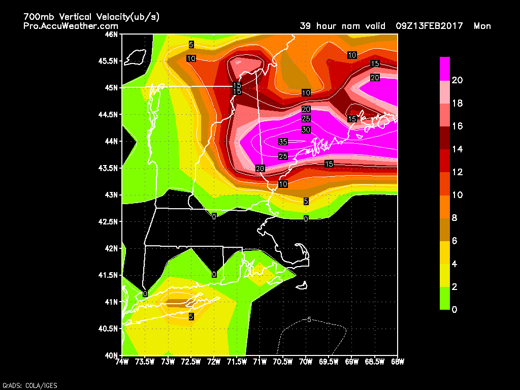
When storms deepen that explosively, a number of really cool things happens. First, it snows really hard. This map from the 18Z NAM shows a band of absolutely insane upward motion on Monday morning. Look for snowfall rates on the order of 2-4″/hour or more in the heaviest mesoscale bands. It’s important to note that it’s impossible to predict where these bands will set up more than a few hours in advance. At the moment, coastal Maine looks like the best bet for one of these bands though it’s far too early to say exactly which towns end up under it. For the science behind mesoscale banding, be sure to check out my post on the matter from our last storm only a couple of days ago!
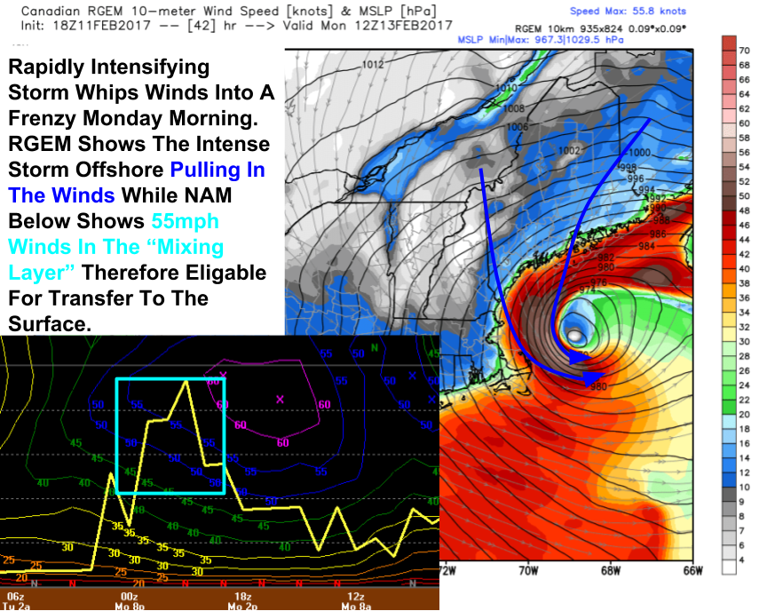
18Z NAM And RGEM Models Showing Intense Winds Monday. Images From BUFKIT and Weatherbell
The second cool thing that happens is that it gets really windy. As the pressure gradient tightens between a low that has the same pressure as a category 2 hurricane and a strong high pressure system nearby, the winds will take off Monday morning. Look for gusts along the coast in the 50-60mph range with 30-45mph winds away from the coast. Just be thankful the storm isn’t another 50 miles west or we’d be getting into the hurricane force winds lurking just offshore. Not a good day to be out on the water! Winds this strong plus the threat for heavier/wetter snow along the coast will mean power outages are likely Monday for coastal communities. If you’re especially vulnerable to power outages, be prepared to be in the dark Monday night!
The other impact of the winds is that they’ll be blowing around the snow both from today and from the storm. Look for visibilities to approach zero Monday morning as the winds develop. The result will be blizzard conditions and a blizzard watch is out for the coast for Monday. Only travel Monday morning if it’s an absolute emergency!
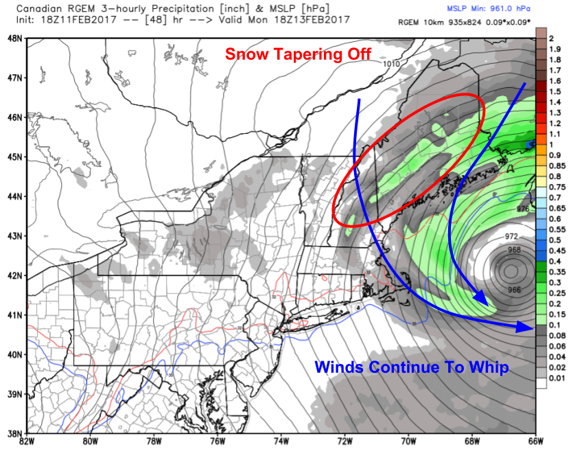
Snow will wind down Monday afternoon as the storm pulls away to the east. While snow will diminish in intensity and eventually taper off, winds will still be going strong resulting in continued low visibility/blizzard conditions through the evening hours Monday. Winds will calm down Monday night into Tuesday morning.
While coastal flooding is always a concern with storms this strong, winds will be mostly out of the north and will probably push more water offshore than onshore in most areas. However, the intense winds will generate very large waves which will likely cause beach erosion and even some minor splashover in the typical spots. High tides to watch will be 12 AM and PM Monday.
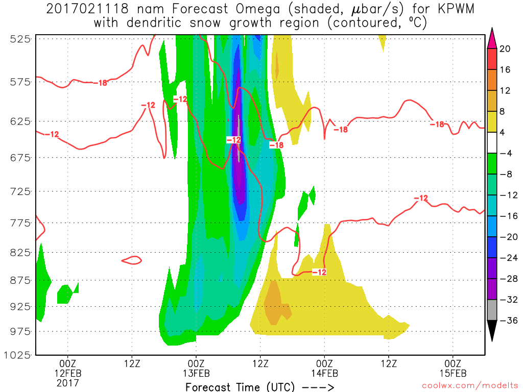
18Z NAM Showing Intense Upward Motion Through The Dendritic Growth Zone Monday Morning. Image Credit: Coolwx.com
So will this snow be cement or fluff? The answer is, for most, fluff, and for some along the coast, a mix. To get fluffy snow, you need cold temps, strong lift through the snowflake production zone (-12C to -18C, wherever in the atmosphere that happens to be) and you need the snowflake production zone (aka dendritic growth zone) to be full of moisture. We have all the ingredients for fluff away from the coast. However, at the immediate coast, temps will begin on the warmer side and as a result, some heavier/wetter snow could kick things off Sunday evening resulting in the threat for power outages there.
18Z NAM Showing Different Dynamics Monday
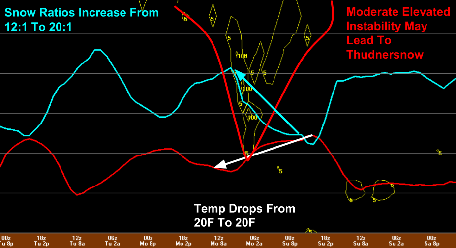
Here’s a plot from the 18Z NAM showing various parameters for Portland through time (which moves forward from right to left along the x-axis). Notice the sharp increase in snow ratios (light blue line) going from a typically heavy 10:1 ratio to a very fluffy 20:1 ratio as temps cool from 30F to 20F. Also notice the presence of instability aloft. That combined with tremendous upward motion means we could be woken up by claps of thunder Monday morning. Hopefully we’ll get the continuous thundersnow parts of CT saw with the storm Thursday but even one strike would be cool! Keep your eyes and ears open!
Total Snowfall Forecast Through Monday Evening
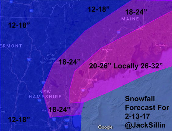
Here’s how much snow I think will fall. QPF values (liquid equivalent) range from a little under an inch north to over 2″ on the coast. Given fluffy ratios away from the coast, that inch could quickly turn into 18 or even 20 but confidence in the full inch falling is low enough for a 12-18″ forecast for the mountains. Along the coast, around 2″ of QPF is forecast but some of that will fall at lower ratios (or else we’d be looking at over 3 feet!) which means amounts will be held back to right around the 2 foot mark. In a band or two near the midcoast, I wouldn’t be shocked to see a 30″ report based on the fluff factor that will begin to set in as the storm wears on. I’ll adjust these numbers with any new data tomorrow morning!
More updates tomorrow both here and on twitter @JackSillin.
Quick update this evening as I’m at the USM track for an indoor track meet. I’ll focus this update on the light to moderate snow tomorrow, leaving our Monday blizzard for when I have more time.
18Z NAM Showing Light To Moderate Snow Tomorrow Afternoon. Image Credit: Weatherbell
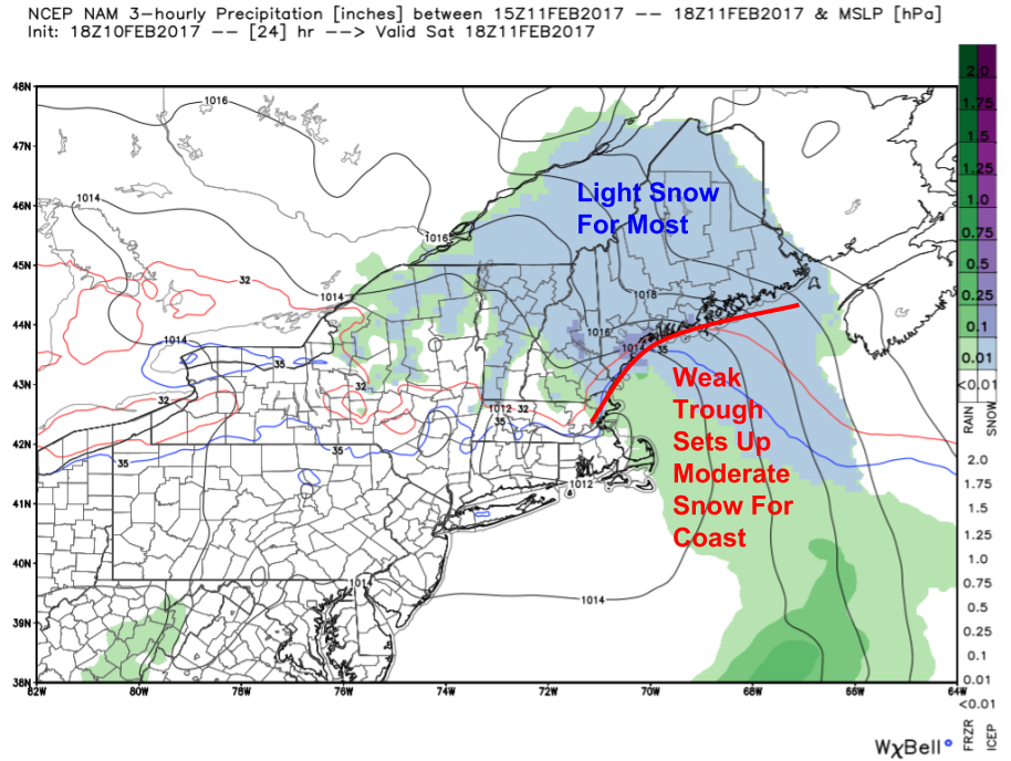
Light snow will develop early tomorrow morning for most. Light snow will continue through the day away from the coast where moderate snow will develop in the early afternoon as a coastal front sharpens up just offshore. Temps will rise slowly into the mid 20’s north and the low 30’s south. The precip should remain all snow and it should be of the fluffier nature.
12Z GFS Showing Weak Energy Approaching Tomorrow With Stronger Energy Over The NW Plains For Monday. Image Credit: Accuweather
The weak nature of the precip will be a result of the weak nature of the energy aloft. Notice the lack of deep reds/oranges along with only a weak dip in the height lines. This indicates forcing for precip will be limited at best and most of it will come outside the dendritic growth zone in the lower levels. So how much snow should we expect?
Snowfall Forecast Through Tomorrow Evening
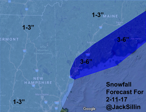
Here’s the current forecast. The heaviest amounts will be across the midcoast where a few 5 or 6″ amounts are possible. Most will see 1-3″ with 4-5″ amounts along the coast NE of Portland.
Our next storm will arrive Sunday afternoon and crank away into Monday. An early look at amounts shows 1-2 feet are likely for many with a few midcoast spots possibly eclipsing the 2 foot mark. I’ll refine and explain these amounts tomorrow evening. In addition to the snow, winds will crank up behind the low pressure system resulting in blizzard conditions along the coast. Another storm could bring significant snow to the region again late in the week. Welcome to winter!
After several days of fairly active and interesting weather, we’ll get a day (and only a day) off today. Skies will be party sunny, temps will be very cold, and winds will keep blowing the snow around but for the first time since Monday and the last time until Tuesday, we won’t be adding to our snowpack. Look for highs in the low single digits above zero north and in the high single digits to low 10s in the south. Winds will be zooming out of the NW towards our developing storm at 30mph this afternoon so the wind chill will make things feel even colder. The winds will also blow around our new fluffy snow resulting in more slick spots and occasional low visibility.
Our next little storm will arrive late tonight into tomorrow and our next potentially big storm will roll in Sunday night.