Our recent upslope/downslope pattern will still be going strong today as westerly winds drive our weather. Up in the mountains, look for cool temps, more clouds than sun, and the chance for a flurry or two. Highs in the mountains will be in the mid to upper 10’s. Along the coast, more sun than clouds is expected along with dry conditions and milder temps. Highs along the coast are expected to top out right around freezing.
Some light snow is possible in spots tomorrow before heavier snow/sleet/ice moves in Tuesday into Wednesday.
We’ll continue our stretch of weather being governed by W/NW winds today as light breezes continue behind a cold front that passed through yesterday. Some colder air moved into the region behind that front and as a result, highs today look to be a bit cooler than they have been in recent days. Look for temps to top out just shy of 20 in the north and just shy of 30 in the south. Skies will feature a mix of sun and clouds with more clouds than sun up in the mountains and vice versa along the coast. Mountain snow showers will continue today but will be lighter and less widespread as the moisture supply gradually dries up.
More interesting weather is on tap for early next week.
Today will feature moderate temps, a mix of sun and clouds, and the chance for snow showers or squalls as a cold front moves through. Look for highs to range from the low 20’s north to just above freezing in the south. A passing cold front will bring more snow showers and squalls to the region beginning in the mountains around noon and ending up on the coastal plain by 3 or 4 PM. They’ll move offshore by sundown. They’ll bring low visibility and a quick coating to possibly an inch of snow so look out if traveling this afternoon.
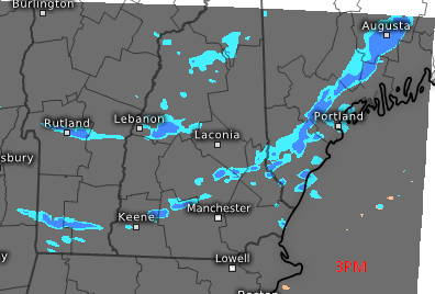
Kachelmann Swiss Model Showing Snow Squalls Approaching The Coast This Afternoon. Credit: Kachelmann
Here’s a visualization of the snow squalls. Not everyone will get one but many will, especially in Maine. It might be a little touchier in NH.
Some more light snow is possible Sunday before a larger storm of unknown impact next week.
Today will feature light snow this morning followed by partial clearing in the afternoon. Look for a general 1-3″ of snow with a few 4″ amounts possible along the coast. Light snow will continue through around noon when it will taper off to snow showers from SW to NE. Most areas should be dry and starting to catch glimpses of the sun by 3 or 4 in the afternoon. These glimpses will be most likely in the SW where they are expected to bring temps a little above freezing for highs. Farther NE, the clouds will keep the cold air in place and thus temps will be a bit cooler in the 23-28 range.