All posts by Jack Sillin

I’m a third-year atmospheric science student at Cornell University who has been blogging about the weather since 2011. While I’m not officially a meteorologist, I have accumulated a bit of experience forecasting both local weather (in western Maine and New Hampshire) as well as national/international weather during my time writing for weather.us and weathermodels.com. I also have experience programming in Python, teaching concepts in weather forecasting, and communicating forecast information to general audiences.

Much Warmer Today

Hello everyone!

Today will feature much warmer temps as southerly winds bring air from the tropics into the region. Look for highs a few degrees below 40 for most of the region, with SW NH enjoying temps a few degrees above 40. Skies will be overwhelmingly cloudy, with dense fog developing by this evening. As for precipitation, radar loops show some in progress this morning. A light mix of rain, sleet, and freezing rain will continue for another couple hours before generally dry conditions return.

More rain arrives tomorrow.

-Jack

Slightly Cooler Today

Hello everyone!

Our warming trend this week is a “two steps forward, one step back” type of situation, and today will fall under the “one step back” category. High pressure will move overhead, meaning that we’ll see sunny skies and light winds, but also cooler temps. Look for highs ranging from the mid 20’s in the north to around 30 in the south. Skies will feature more sun than clouds, and no precipitation is expected. Our upward temperature trend will continue tomorrow with rain arriving by Friday.

-Jack

Warm And Breezy Today As Our Warmup Continues

Hello everyone!

Today will feature warmer temps and breezy WNW winds as our warming trend continues. For the first time since Christmas Eve, 15 days ago, the coastal plain will see highs above freezing, even if it’s just by a couple degrees. Highs in the mountains will rise into the mid to upper 20’s. WNW winds will result in an upslope/downslope pattern for clouds and precip. Snow showers will continue with mainly cloudy skies in the mountains, while the coast will see a mix of sun and clouds with only the slight chance for a brief flurry.

Enjoy the warmth, more of it is on the way for Thursday and Friday before a potential freezing rain event Saturday.

Jack

Much Warmer With Light Snow Today

Hello everyone!

Today will feature much warmer temperatures along with light snow as a front approaches from the west. One round of snow has already moved through the area early this morning, and the next round of widespread snow will arrive this afternoon. In between, scattered light snow showers are expected in the south, with steadier snow in the north. Snow totals will range from a dusting in SE NH to 3″ in the mountains of NW ME. Highs today will feel downright tropical compared to the past two weeks, ranging from 20 in the north to 30 along the coast. This warm air will be thanks to southwest winds that will be breezy at times today.

-Jack

One Last Day In The Deep Freeze

Hello everyone!

The Arctic airmass that has been with us since December 25th is saying goodbye today. High pressure is about to move to our south instead of to our northeast, and as a result, southwesterly winds will begin the process of warming us up starting tomorrow. Meanwhile though, today will be another day of bitter cold across the area. Highs will range from zero in the north to +10 in the south which, while cold, will be a noticeable improvement from lows this morning which were as cold as -30. Skies will start sunny today, but become cloudy this evening as our next weak storm system approaches from the west. This system will bring a quick 1-3″ of snow to the area tomorrow.

-Jack

Falling Temps Today As Arctic Air Pours In Behind Our Departed Blizzard

Hello everyone!

Hope you enjoyed yesterday’s balmy conditions! Tropical air surged up the coast associated with our storm, boosting the temp in Portland to a toast 30 degrees! The last time we saw temps that high was Christmas. The warmth is ending today due to gusty NW winds that will set up a nonstop pipeline directly from the Arctic Circle. Temps are in the single digits north and low teens south this morning. By evening, all but the immediate coastline will be below zero, with temps dropping towards -15 in the mountains. Wind gusts of 30-45 mph will make those temps feel even colder. Additionally, the gusty winds will continue to blow snow around today so you may find snow covered roads even though the sun will be peeking through the clouds more and more as the day goes on. Snow has long since moved out into the Canadian Maritimes, so a dry day will remain for most of us, though snow accumulations will continue in the favored upslope areas of the mountains.

Even colder weather is en route for tomorrow. Bundle up!

-Jack

The Calm Before A Powerful Storm Today

Hello everyone!

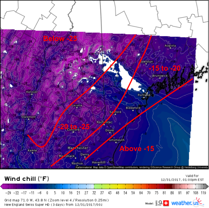
Today will feature the calm before the storm here in Northern New England as we have about 24 hours to go until snow begins to crank up in advance of an ocean low moving up the coast. Temps today will be much warmer than recent days, with highs soaring into the 10’s for most, and even getting into the low 20’s for SE NH. There will be a mix of sun and clouds today, with clouds slowly taking over as we head into the evening.

Our storm will rapidly intensify off the Florida coast this afternoon before racing NNE tonight. Expect snow to begin in the early morning hours in Southern NH with Portland seeing flakes by 7 or 8. By 10 AM, everyone should be seeing at least light snow. As we move towards noon, intense bands of snow will rotate in off the ocean, bringing 2-4″ per hour snowfall rates, wind gusts to 65 mph along the coast, and blizzard conditions. These bands will continue to impact mainly eastern parts of the region through the evening, before snow tapers off overnight.

Here’s an animation showing the 24 hour evolution of our storm from tonight through tomorrow night according to one model’s forecast. While I don’t have faith in the model’s placement of any given band, it does do a good job highlighting the overall setup. The animation is from weathermodels.com, our new subscription service from weather.us. Try it out for free until January 25th if you’re interested!

For a full breakdown of the storm and its impacts, check out my latest two weather.us blog posts. The first one (from 1/1) discusses the overall setup and some of the meteorology behind the storm itself. The second one (from yesterday) discusses each of the storm’s impacts from freezing rain in Florida to our blizzard here in Maine, along of course with some analysis of what’s driving each impact and why I’m expecting what I am.

-Jack

Arctic Airmass Remains In Place Today

Hello everyone!

Today will feature the continued presence of our amazingly persistent Arctic airmass. This is the last day of the first part of the bitter cold as we’re in for a two day reprieve tomorrow and Thursday. Miss the subzero temps? You won’t have to wait long as an even colder shot of Arctic air blasts into the area Friday into Saturday. Highs today will range from a relatively balmy 0 degrees in northeast areas to a toasty 10 above in SW NH. Satellite imagery shows a weak and moisture starved disturbance moving SE through Ontario this morning. This system will spread clouds across the area this afternoon, with a few snow showers expected in the mountains. Otherwise, you won’t notice much in the way of sensible weather changes as it passes through.

A significantly milder day is in store tomorrow with highs in the 10’s for nearly the entire region! This comes before the chance of a significant storm on Thursday, which I discussed in last night’s weather.us blog.

-Jack

More Bitter Cold Today

Hello everyone!

Today will feature another day of bitter cold as our Arctic airmass shows no signs of easing its grip on the region. Temperatures this morning range from 3 below in the warmest part of SE NH to 30 below in the coldest mountain valleys. Temps won’t recover much today, with highs once again ranging from around 10 below in the north to 5 above in the south. Skies will be mainly sunny as bone dry high pressure remains firmly in charge.

-Jack

Bitter Cold Returns Today

Hello everyone!

Yesterday was a nice respite from the worst of the deep freeze as temperatures made above zero for most, and even got to double digit readings for some parts of the coast. Today, a storm developing well to our southeast will bring a reinforcing shot of bitter cold, and we’ll be headed back to the brutally low temperatures of a few days ago. Highs will range from -10 in the north and mountains to +5 along the coast.  Most of the area will remain sunny and free of precipitation today, however upsloping NW winds will keep clouds and a few flurries in the mix for the mountains.

This map from the Swiss Super HD model shows wind chills bordering on dangerous this afternoon. Ignore the large swath of null values downwind of Mt. Washington where the model thinks that winds are calm or nearly calm due to the influence of the mountain. Wind chills in the Sebago region will be just as brutal as anywhere else, dropping below -20 for much of the day today.

Bundle up if your NYE plans take you outside tonight, even for a short period of time!

-Jack