All posts by Jack Sillin

I’m a third-year atmospheric science student at Cornell University who has been blogging about the weather since 2011. While I’m not officially a meteorologist, I have accumulated a bit of experience forecasting both local weather (in western Maine and New Hampshire) as well as national/international weather during my time writing for weather.us and weathermodels.com. I also have experience programming in Python, teaching concepts in weather forecasting, and communicating forecast information to general audiences.

Cool And Damp Today

Hello everyone!

Today’s weather will be your classic April Maine special. Look for onshore breezes along with cloudy skies, cool temps, and morning steady rain giving way to afternoon drizzle and fog. Highs will range from the mid 30’s north where some snowflakes could mix in to the low 40’s south. Rain will arrive in NE areas in the next couple of hours.

Looking for something to blame our dreary weather on? Check out this graphic I did a couple days ago about the pattern change from warm and dry to cool and wet.

-Jack

Drier And Slightly Warmer Today

Hello everyone!

Today will feature mainly cloudy skies along with the slight chance for a sprinkle/shower. Temps will be warmer than yesterday but still on the cooler side, ranging from 45 in the north to a little below 60 in the south. Skies will feature more clouds than sun though most folks should at least get a couple peeks of blue sky. We’ll be mainly dry though I can’t rule out a stray shower or sprinkle as there’s still a bit of moisture lingering around.

More rain tomorrow.

-Jack

Cool And Cloudy For Many Today

Hello everyone!

Today will feature cool temps, cloudy skies, and onshore winds as a cold front approaches the area. Look for highs ranging from 40 along the coast and in the mountains to 50 in SW NH. Skies will be overcast except possibly for a few sunny breaks in SW NH hence the warmer temps there. As for precip, showers will move in this evening falling as rain for most but possibly mixing with snow in the higher terrain/far northern towns.

More cool and cloudy weather for the rest of the week.

-Jack

Clouds Slowly Increase Today

Hello everyone!

Today will feature a mainly sunny and cool start before temps quickly rebound into the mid 50’s north and low to mid 60’s south. Clouds will slowly increase later this afternoon with a few showers possible by evening across northern and western areas. A sea breeze will develop this afternoon across coastal areas resulting in cooler temps there but otherwise, mild conditions are expected. One more day of warmth arrives tomorrow before we head into a more prolonged colder stretch.

-Jack

Clear And Cool Today

Hello everyone!

Today will feature mainly sunny skies along with cool temps as we sit in one of our little cooler stretches. Look for highs ranging from a little above 40 in the north to a little below 60 in the south. Clear skies are expected with no precip to speak of. Enjoy the nice spring weather! More warmth is en route for the weekend but precip will accompany it so watch for a few raindrops if you have plans this weekend.

-Jack

Cooler But Sunnier Today

Hello everyone!

Today will feature a NW flow pattern where the mountains will see clouds along with light sprinkles/flurries and the coast will see mainly sunny skies along with dry conditions. Look for highs to range from just below 50 in the north to just above 60 in the south. NW winds will be breezy today, occasionally gusting over 30mph. Warmth returns for the weekend, especially Sunday. Remember the 3 on 3 off pattern that I talked about yesterday!

-Jack

Cooler And Cloudier With Showers Today

Hello everyone!

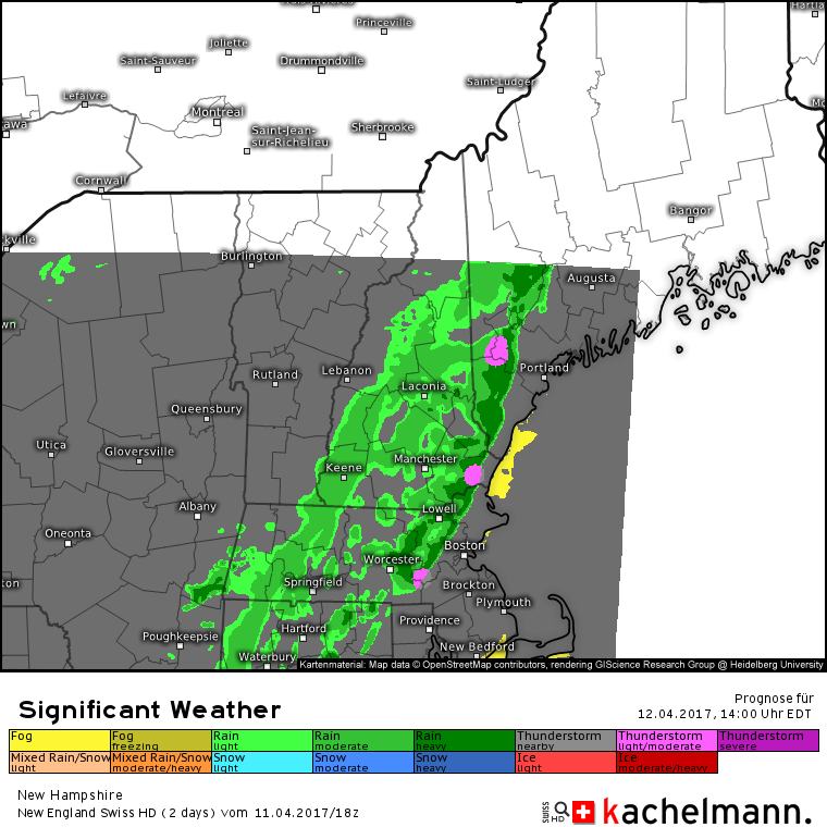
Today will feature a mix of sun and clouds with coastal areas seeing the most sun and the mountains likely remaining overcast for much of the area. The cold front struggling to motivate to make its way over in our direction yesterday is still trying, albeit not that hard, to make it to the coast. Despite its laziness, its goal will be achieved in the early evening tonight with a line of showers and possibly a rumble of thunder accompanying it. The showers will be brief and will arrive between 2 and 4 PM along the coastal plain. The mountains will be closer to the front this morning and thus will have off and on showers all day.

Here’s one depiction of the line of showers with an isolated rumble (pink) according to the Swiss model. If you’re interested, feel free to check out some of the other Swiss model data here https://kachelmannwetter.com/de/modellkarten/newengland/new-hampshire/significant-weather/20170412-1800z.html

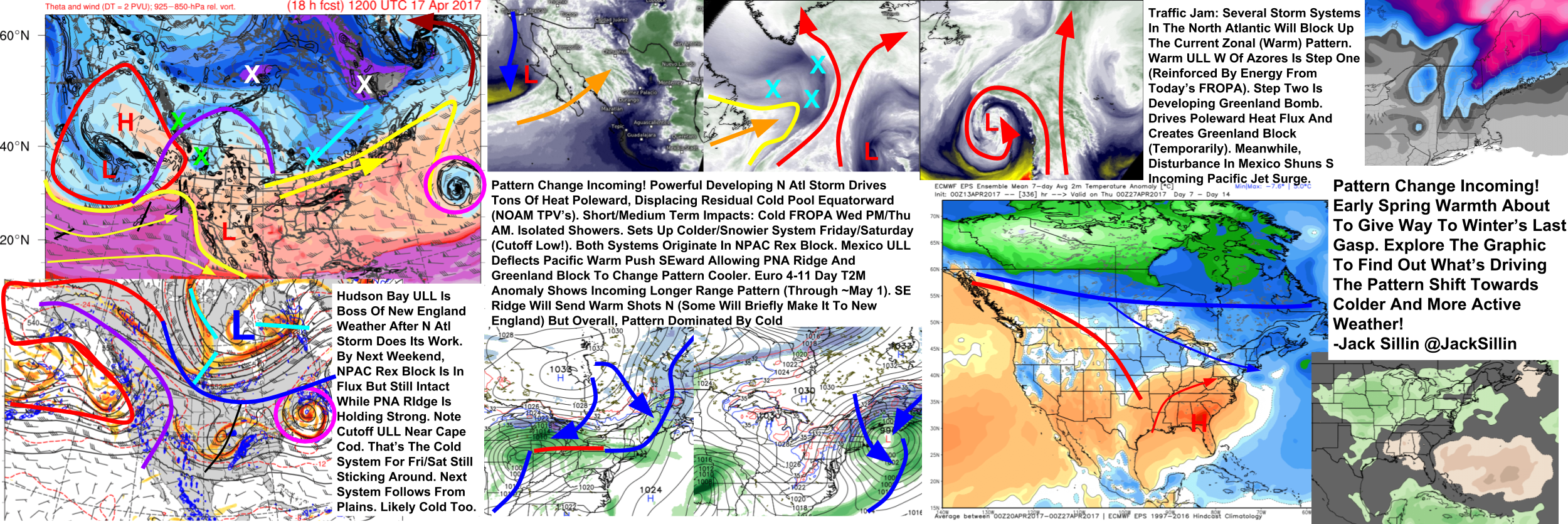
We’re entering into a pattern of oscillating temperatures with a ~3 day return period. We’ve had 3 days of warm weather (Sunday, Monday, Tuesday) and now we’re about to have 3 days of cooler weather (Wednesday, Thursday, Friday) before another ~3 day warm stretch (Saturday, Sunday, maybe Monday). Expect the 3 day rule to continue to hold fairly true as we head into the second half of April with the balance of warm/cool slowly shifting in favor of the warmth as we get towards May.

-Jack

Balmy Spring Weather Today

Hello everyone!

Today will feature very warm temps, fairly sunny skies, and mostly dry conditions. A cold front is slowly drifting in our direction though it’s moving with the haste of an overtired teenager on a Saturday morning so we can expect a pretty nice day before it finally gets around to showing up. Look for temps to rise up to 55 in the north behind the cold front and under considerable cloud cover while highs in the south will likely touch 80 in a few of the SW interior warm spots. The coast will be cooler due to a sea breeze which will develop this afternoon and keep temps in the 60’s.

-Jack

More Spring Warmth Today

Hello everyone!

Today will feature mainly sunny skies, light winds, and warm temps as our spring warm stretch continues. Look for highs to range from 65 along the coast and in the mountains to 75 in interior SW NH. A sea breeze will be the culprit behind the coastal cool temps as the Gulf of Maine is still in the 30’s! More warmth tomorrow before a cold front knocks temps back down Wednesday. There could be a few showers or storms associated with that boundary but no significant issues are expected.

-Jack

Sunny And Mild As Springy Stretch Begins

Hello everyone!

A shift in the pattern means that we’re set to kick off an amazing stretch of weather. Today, expect full sun with highs around 60 in the south and around 50 in the north. Tomorrow, those numbers go up 5 degrees or so. On Tuesday, we get another 5 degrees with highs around 60 in the north and a little over the 70 degree mark in the south. Full sun is expected for each of the three days with the exception of Tuesday when some clouds could pop up around the international border.

Enjoy the spring weather!

-Jack