I’m a third-year atmospheric science student at Cornell University who has been blogging about the weather since 2011. While I’m not officially a meteorologist, I have accumulated a bit of experience forecasting both local weather (in western Maine and New Hampshire) as well as national/international weather during my time writing for weather.us and weathermodels.com. I also have experience programming in Python, teaching concepts in weather forecasting, and communicating forecast information to general audiences.
Our unfortunate little warm stretch continues today as another warm front rolls overhead. Look for mainly cloudy skies with mild temps and mainly dry conditions though a morning shower is possible. Highs will again top out in the 40’s for most.
Today will feature more in the way if warmth as our little break from winter continues. Look for slowly fading sun to bring temps up to the 40 degree mark for most with mid to upper 30’s north. A few light sleet/freezing rain showers are possible late tonight into early tomorrow morning so use caution if heading out early tomorrow.
Today will feature temps that are much more reasonable for February however still on the warm side. Look for highs in the low to mid 30’s north and upper 30’s to low 40’s south. Skies will feature a mix of sun and clouds and no precip is expected.
Today will feature ridiculously mild weather as a cold front approaches from the north. Look for highs in the mid 40’s north and mid 50’s south under partly to mostly sunny skies.
Clouds this morning will give way to sunnier skies this afternoon as a weak disturbance drifts by overhead. Look for milder temps to continue as highs rise to freezing in the north and up to around 40 in the south. Winds will be noticeably lighter than yesterday. Watch for black ice this morning as any of yesterday’s melting refroze in last night’s cooler temps. This trend of melting/refreezing will continue through the week as daytime highs rise above freezing and nighttime lows sink below the 32 degree mark.
Today will feature the beginning of the 7th inning stretch of our winter. We’ve had lots of fun and there’s more to come, but we’re taking a break before the final push. We have about a week of mild and calm weather ahead before winter’s final push in early March. Today will feature partly to mostly sunny skies along with a NW breeze and dry conditions. Look for highs in the mid 20’s north and low to mid 30’s at the coast.
Dry and warm weather will continue through the weekend.
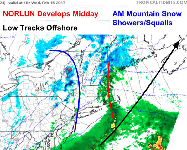
Our next storm is already here across the mountains this morning as low pressure approaches from the west. Look for snow to continue through the day in the mountains while a mix of snow and rain develops towards the coast. Temps will range from the 20’s up north to the 30’s along the coast. Temps fall this evening and change everyone over to snow which is likely to be heavy at times as a Norlun trough combines with a storm offshore to bring intense bands of snow to the area.
More snow is on the way! A clipper system will approach the region tonight before capturing and pulling a storm from the SE US up the coast in our direction. Precip will start tomorrow morning in the form of snow across the mountains. As the cold front associated with the clipper approaches, some of that snow may be squally in nature. Then, the real fun begins tomorrow mid day as a norlun trough sets up in SW Maine. Moisture will be funneled west along this trough and it will produce a band of very heavy snow. As the coastal low pressure system develops offshore, more bands of heavy snow could rotate into the region before the storm moves offshore Thursday morning.
18Z 3km NAM Showing Our System Getting Into Place Tomorrow Mid Day. Image Credit: Tropical Tidbits
Here’s a look at one model’s depiction of the weather map tomorrow afternoon at 1 PM. Note the Norlun trough developing along the New England coastline as moisture from the offshore storm is funneled back into the region. This process is a sure bet, where exactly it sets up and what the temperature is along the coast while it’s going on isn’t. Right now it looks like locations near Portland will start with a light rain/snow mix before going over to snow in the early evening. Exactly when this transition happens will be crucial in determining how much snow falls.
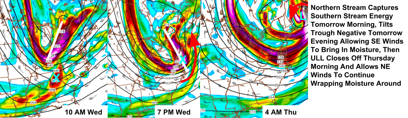
18Z NAM Showing Upper Level Dynamics Favorable For A Storm. Image Credit: Accuweather
The Norlun trough will then become just another band on the west side of a coastal low due to upper level dynamics favorable for cyclogenesis offshore. A trough is diving SE out of the Great Lakes this evening and will ingest a disturbance currently moving through Oklahoma. The OK disturbance will tilt the trough negative tomorrow evening allowing for moisture to stream into the region. The upper level low will then close off to our south helping to keep precip going by wrapping in moisture and precip from the NE.
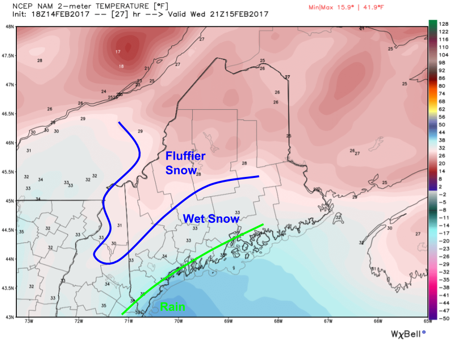
18Z NAM Showing Marginal Temps As Precip Arrives Tomorrow Afternoon. Image Credit: Weatherbell
As precip gets going tomorrow afternoon, the biggest limiting factor will be surface temps. In the mountains, things will be plenty cold enough for a fluffy snow. More pow for the ski areas! Along the immediate coast, precip will start as rain. In between, a wet snow will fall. Exactly where the rain/snow line sets up and how fast it collapses SE will determine if the coast gets 6 or 16″ of snow. Any coastal rain will quickly turn to snow as cold air moves in later in the evening tomorrow.
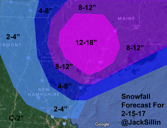
Snowfall Forecast Through Thursday Afternoon
Here’s what I’m thinking with regards to snowfall amounts. There will be a sharp gradient in NH as it’s a little uncertain how far west the heavier bands get. I’ll update this tomorrow when I know more. The snow in the mountains will be of the fluffy variety and of the wet/heavy along the coast. With all the recent snow, be mindful that loads on roofs will be getting very heavy so be sure to clear off as much as you can!
If you’re getting annoyed at this pattern, do know that a thaw is coming next week. If that thought makes you sad, winter will likely return to kick off March.
Today will feature quiet weather as high pressure builds overhead. Look for a mix of sun and clouds, light winds, and dry conditions. Temps will rise into the mid 20’s north and the low 30’s south. We have one more storm in the pipeline tomorrow into Thursday before we’re back to January’s mild and boring pattern.
Our blizzard is here and ongoing across Maine this morning. Precip has moved out of western NH but is still going strong over ME as bands rotate in around our ocean storm. Winds are only beginning to wind up as our storm intensifies so expect continuing deterioration of visibility even as snow begins to lighten up. From the looks of it, an additional 4-8″ can be expected from Portland to Augusta and points NE. 2-4″ more is likely from Kittery-Fryeburg and NE while NH is likely only to see another coating-2″ on top of what’s already fallen. Winds will gust in the 40-50mph+ range along the coast and in the 20-40mph range inland which will blow around all the light/fluffy snow resulting in very low visibility. Winds could also be enough to bring down some trees which could result in power outages.
HRRR Model Showing Heavy Snow Departing Today. Credit: Weatherbell
Snow will wind down from W to E during the day with snow already nearly done in the CT river valley and snow continuing into the early evening along the midcoast. The HRRR Model shown above gives a good visualization of this trend. Temps will linger in the 20’s for most today as daytime heating is balanced out by colder air being drawn into the storm from the north.
More snow is possible Wednesday into Thursday with some folks likely seeing another foot and possibly more. More details forthcoming!