Hello everyone!
Today will feature cool but not cold temps with highs in the 30’s south, 20’s north. These lovely temps can be enjoyed today under sunny skies and light winds.
-Jack

Hello everyone!
Today will feature cool but not cold temps with highs in the 30’s south, 20’s north. These lovely temps can be enjoyed today under sunny skies and light winds.
-Jack
Hello everyone!
Our cold front has moved through and now it’s time to experience the final season given to us by our storm: fall. Temps will be falling today and we’re currently starting a few degrees on either side of freezing depending on location. By the end of the day, we’ll be a few degrees on either side of 15 or so, colder north, warmer south. Skies will be mainly cloudy in the north where upsloping could keep a few snow showers around. In the south, downsloping will act to clear skies out resulting in mainly sunny conditions.
-Jack
Hello everyone!
Today will feature a wild day of weather as a decaying storm passes just to our west. Thunderstorms are cranking through the region this morning though they should clear the Midcoast by around 7AM. In the wake of these storms, some partial clearing is possible this morning before we get hit by the back side of the storm. Right now, it looks like this will feature mainly rain showers this afternoon and evening though snow will be mixing in from north to south. I have doubts as to whether the snow line can make it all the way to the coast before precip departs but the mountains will likely see a period of accumulating snow this afternoon/evening mainly in the higher terrain where a couple of inches are possible. The foothills could see a coating especially at elevation and especially in the northern areas while the coast likely escapes any snow. Rain and snow move out late tonight/early tomorrow morning.
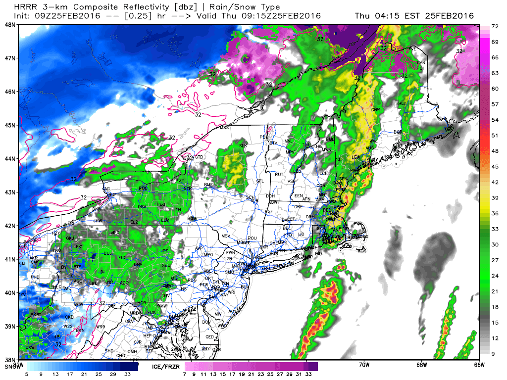
Here’s the HRRR model showing heavy precip moving out this morning followed by lighter precip this evening. Notice the mountains beginning to change to snow at the end of the loop. I expect snow to push as far south as the foothills before precip moves out. Little to no accumulation is expected outside of the higher elevations where upsloping will help enhance precip.
Surface observations indicate some sub-freezing holdouts in the foothills this morning with Bethel, Paris, and Livermore all reporting below freezing conditions. In those areas, watch for slick spots as some black ice is certainly possible. Any remaining pockets of could air could wash out in southerly flow this morning though the cold front is already just west of NYC and racing east so that window is closing. Farther south, record high temps have already been broken this morning as temps jumped into the 50’s. I could see a few more degrees of warming before the sun comes up but after the cold front passes later this morning, expect temps to slowly begin to cool.
-Jack
Hello everyone!
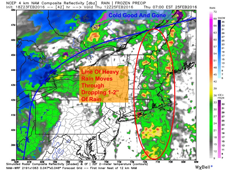
An absolute mess is occurring across the region with surface observations showing below freezing temps across much of the interior. With moderate to heavy rain falling, ice accretion remains a fairly significant concern. Freezing rain will slowly transition to rain this evening as warm air noses in from the east. This transition will be slow to occur especially over inland areas. Storm total ice is likely to be in the .25-.5″ range which is in line with my forecast from last night.
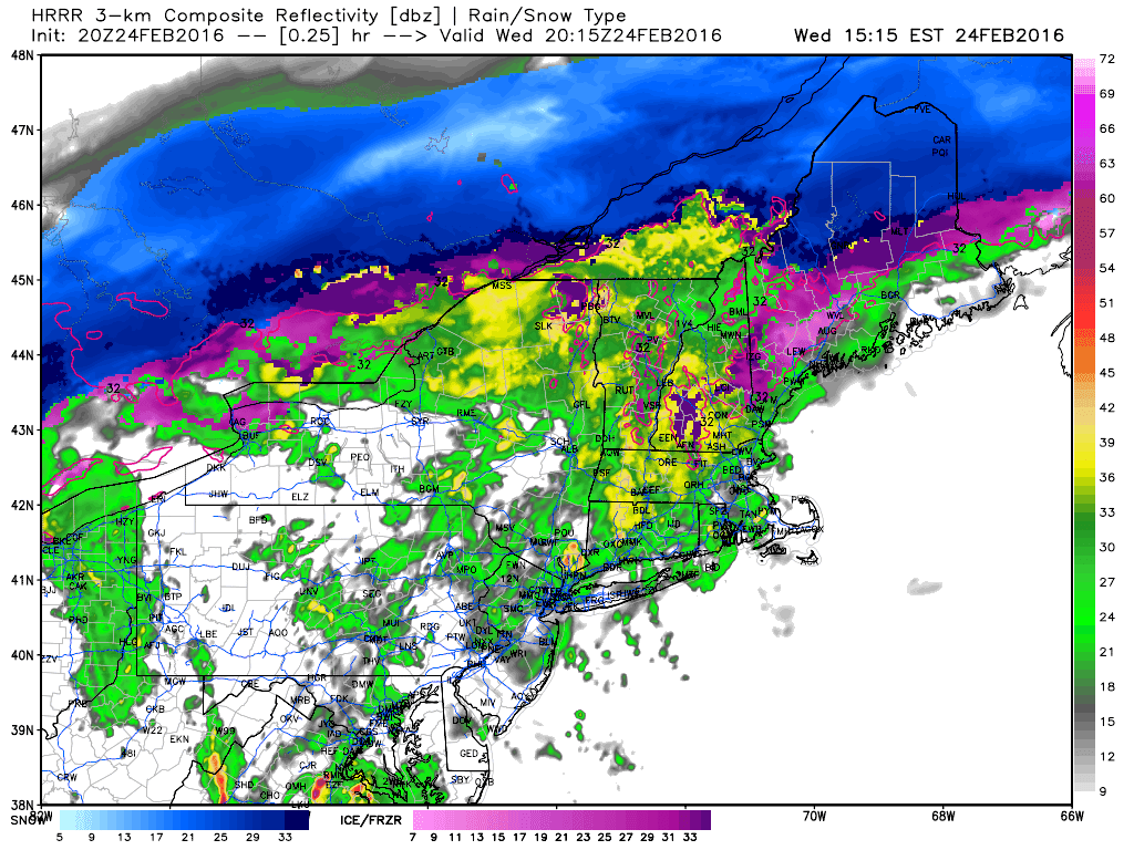
Rain will continue to increase in intensity this evening and the heaviest precip will arrive in the form of a line of showers and thunderstorms late tonight into early tomorrow morning. By this time, cold air should be pushed well to the north and no icing concerns are expected. The concern with this will be winds and heavy rain which could lead to power outages and some nuisance flooding respectively. Winds could gust to 45mph in the stronger storms.
Winds and rain move out Thursday afternoon with some breaks of sun possible. Clouds move back in Thursday evening and a little more snow is possible for the mountains as upsloping kicks in. Accumulations should remain under 3″ and will be confined to the higher elevations.
-Jack
Hello everyone!
Today will feature the first round of our messy storm as cold air tries to remain locked in this morning. Winds are out of the north-east at the surface and everyone, all the way down to the coast, is below freezing. Snow is falling across the area as of 5:30 but warm air is about to punch in aloft as winds at about 2,500 feet are out of the south-east. Warm air is just starting to punch into the midcoast at that level as of 5:30 and the rest of the coast will soon follow.
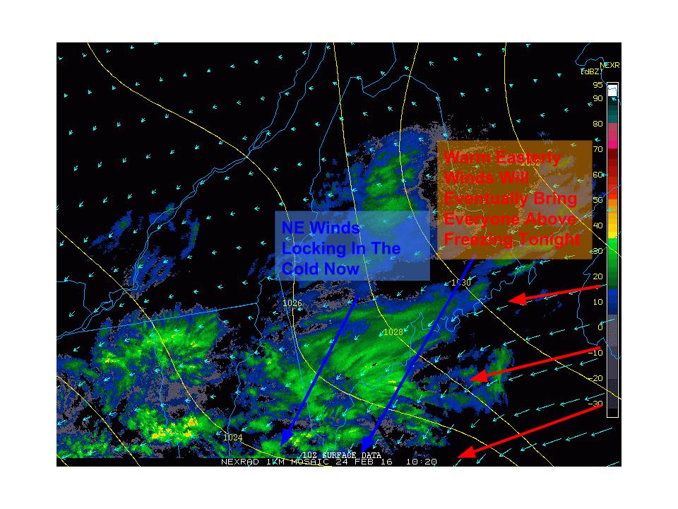
Taking a look at surface obs, NE winds are evident across the entire region which is helping to lock in the cold. This is expected to continue this morning even for the coast and a Winter Weather Advisory has been issued for the entire region which was just expanded to include the coast. Notice easterly winds over the Gulf of Maine. These are warm winds and will eventually cause temps to rise above freezing from SE to NW this evening.

Snow will slowly go over to freezing rain this morning which will slowly go over to rain this afternoon as shown above. Notice the pockets of freezing rain still holding on in the mountains even this evening. Some of the mountain valleys and some of the higher elevations of the coastal plain could hold onto the rain through around 7-9 PM this evening. In places still below 32 around that time, around a half inch of ice is possible which is more than enough to cause tree damage.
Heavy rain and wind move in tonight, I’ll have another update more focused on that this evening.
-Jack
Hello everyone!
Another storm is tracking up the Ohio River Valley this week and it will bring with it a mix of snow, sleet, freezing rain, and rain with the chance for a rumble or two of thunder. This storm is really two storms, one moving offshore tomorrow and another moving to our west Thursday. The first storm has the frozen precip while the second storm has the liquid precip. I’ll break down each and every impact below starting with some snow tonight into early tomorrow morning.
First Storm: Snow
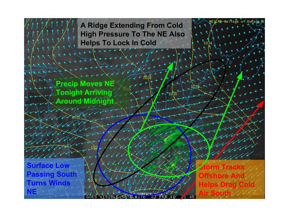
Low pressure is moving NE offshore this evening and will bring us a round of precip tonight into tomorrow morning. Due to a cold dry airmass out ahead of the storm, this precip will start out as snow tonight with a couple inches of accumulation. Warm air will be blasting in aloft and will change snow over to sleet and freezing rain for the AM commute tomorrow. Before the changeover, a few inches of snow are expected but accumulations should remain fairly light. The snow combined with the icy mix will make for a very slick AM commute so be sure to allow extra time for slow travel tomorrow morning.
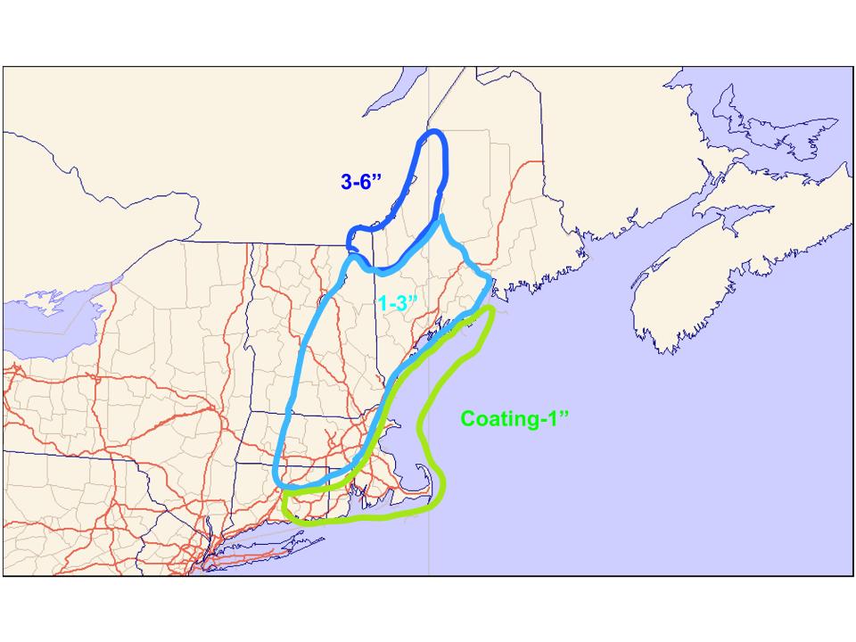
Here is what I expect for snowfall accumulations. The immediate coast could go over to rain fairly quickly so little accumulation is expected there. Most areas see 1-3″ but areas in the far north are likely looking at a good 3-6″ before warm air aloft finally gets up there mid day tomorrow.
First Storm: Ice

Warm air aloft will easily move in tomorrow morning. At the surface however, the cold will put up a solid fight. As a result, freezing rain is expected to be widespread tomorrow. This vertical profile of the atmosphere tomorrow afternoon near Rumford shows what I’m talking about. Snow will form and fall in the upper levels of the atmosphere which are below freezing (upper blue area). They will then fall into an above freezing layer which will feature temps near 5C (41F) and the snow will melt. Just before it falls to the surface, it will encounter more below freezing air. This won’t be cold enough for long enough to refreeze the rain back into sleet but it will be cold enough to allow the rain to freeze on whatever it hits. This is how we get freezing rain. As long as the lowest levels of the atmosphere stay below 32F, ice will continue to pile up. The greatest risk for solid ice accumulation is in the mountains and foothills where cold remains in place the longest. Closer to the coast, the very bottom of the atmosphere will warm faster but a sliver of below freezing air will remain between 500 and 1500 feet in elevation. If you live between those elevations anywhere in Maine, you are at risk for a fairly significant ice event.

Here are my thoughts on ice accumulation. Keep in mind, areas between 500 and 1500 feet in elevation run the risk of up to .5″ of ice even towards the coast. At lower elevations near the coast, less ice is expected and the immediate shorelines will likely escape the ice for the most part as temps quickly rise to above 32F. Also keep in mind that a half inch (.5″) of ice is enough to cause tree damage so power outages are definitely possible during this time in any areas that do get close to that half inch mark.
Second Storm: Rain
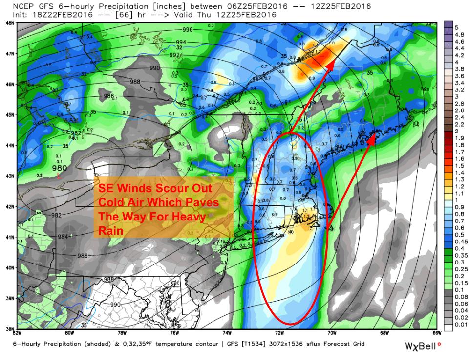
Strong southerly winds eventually get rid of any remaining holdouts of cold air. This will occur from SE to NW Wednesday evening into Wednesday night and the job won’t be completely done for the mountain valleys until the wee hours of the morning Thursday just before the heavy precip moves in. When the heavy stuff does move in, temps will be above freezing for all. While the frozen precip risk will be diminished at this point, we do still have two threats: rain and wind. Between 1 and 2″ of rain is expected for everyone across the area and this combined with warm temps could result in some minor drainage flooding. More impactful river flooding is unlikely though we do run the risk of ice jams on the bigger rivers which very well could cause problems. High winds will be possible with a line of heavy showers Thursday morning and a rumble of thunder cannot be ruled out. Heavy rain clears Thursday afternoon with just residual showers through Thursday evening. Gusty westerly winds will bring temps back below freezing Thursday night and an inch or two of upslope snow is likely during this time as well.
Second Storm: Wind

A band of strong winds aloft will be moving through at the same time the heavy rain will be and thus we run the risk of some of those winds being mixed down to the surface. While these winds could be strong, notice the lack of bright pink/purple we saw last week indicating these winds will be weaker. While I don’t expect any major issues with these winds, I am worried about scattered power outages especially in areas where ice from tomorrow has weakened trees. In terms of how strong I expect the winds to be, coastal areas could see gusts to 50 mph while the rest of the area sees gusts to 40 mph. Winds turn westerly Thursday afternoon and remain gusty but calm down into the 20-30 mph range which should limit any impacts after noon ish Thursday.
To recap, snow moves in tonight followed by ice tomorrow morning. Ice slowly changes to rain from SE to NW Wednesday night with everyone seeing rain by the time heavy precip arrives Thursday morning. Heavy rain will mix down some high winds Thursday morning causing scattered power outages especially in areas where ice on Wednesday has weakened trees. Rain and wind clears out Thursday afternoon as westerly winds bring in cooler and drier air. Upsloping will keep precip up and running in the mountains where an inch or two of snow is likely into Friday morning.
A cold front passes through Saturday night followed by a warm front Monday. Another cold front arrives Tuesday followed by colder temps.
Another update tomorrow morning.
-Jack
Hello everyone!
Today will feature mainly cloudy skies as low pressure moves north. Look for any morning sun to quickly fade to overcast skies and winds will turn northeasterly which will begin funneling cold air south. Highs will be cool today with temps expected to get into the upper 20’s north and lower 30’s south. For details on the upcoming storm, check out my update from last night. I’ll have more this evening.
-Jack
Hello everyone!
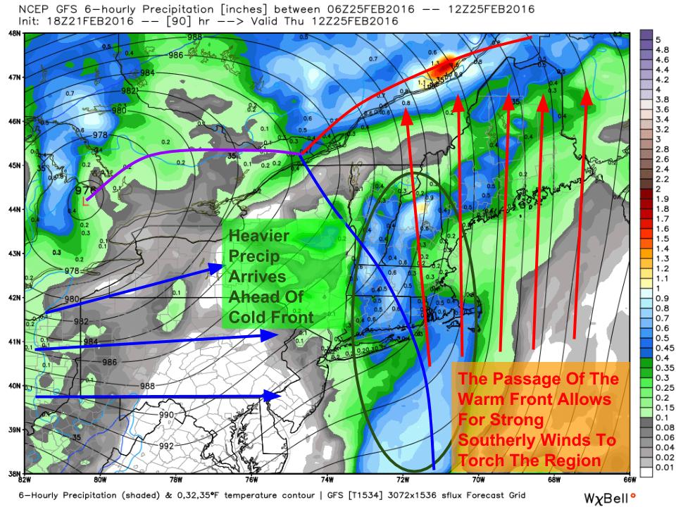
The forecast for Wednesday into Thursday remains on track this evening. As it is drawing nearer, I’ll elaborate a little on the expected impacts which include snow, sleet, freezing rain/ice, heavy rain, and wind. I’ll do a quick rundown of each threat. All in all, this will be a fairly typical inland runner and nothing out of the ordinary is expected for Maine. One wave of precip will arrive during the day Wednesday into Wednesday night while the second will arrive Thursday morning and continue through Thursday afternoon. A third wave is likely following that which will last into early Friday morning.
Wave One: Snow

Ahead of the storm, we have fairly cold air (step outside if you don’t believe me). As per usual, cold air leaves when it pleases and as warm air begins to move north, the first phase of the fight will feature snow Wednesday morning. A general 1-3″ is expected before warm air aloft moves in to turn things over to sleet and freezing rain. A bit more is expected in the mountains where I could see 2-4″. I also wouldn’t be surprised if coastal areas only saw a coating. This will fall overnight tomorrow into the early morning hours Wednesday. As dawn breaks Wednesday, warm air aloft will be gradually changing things over to sleet and freezing rain from south to north.
Wave One: Mix

While warm air will stream in unopposed aloft, the cold will put up a good fight at the surface. High pressure will be slowly sliding east across the Canadian Maritimes and I expect low level cold to hang on for a good long time. The map at left shows winds at the surface Wednesday evening. Notice NE winds still locking in cold air at the surface Wednesday night. The development of weak low pressure offshore will aid in this process. This wind will continue to cause problems even into the beginning of wave two which arrives Thursday morning just as this is beginning to erode. Several tenths of an inch of ice are possible and could lead to power outages especially if it doesn’t get a change to melt before the high winds associated with the cold front arrives.
Wave Two: Rain
Eventually, the cold air will be swept out of the way as SE winds pick up. A cold front will be approaching and ahead of it will be a line of heavy showers with some embedded thunder possible. A general inch to two inches of rain is likely which could lead to minor drainage/urban flooding. Despite that, no major issues are expected as we hardly have any snowpack to melt away.
Wave Two: Wind

As is usually the case with these storms, a band of strong winds will cross the area around the time of the heavy rain. The heavy rain will help mix some of those winds to the surface which could lead to scattered power outages. Notice the lack of bright pinks and purples in this map where we had them covering the entire region last week. Winds this week will be slightly weaker with 40-50 mph gusts most likely (last week we had 50-60 mph winds).
Wave Three: Light Mountain Rain/Snow

As cold air pours back into the area Thursday evening, an upper disturbance will pass overhead which will cause another batch of precip to move through. This will be most widespread in the mountains but everyone has a shot at a quick coating-2″ of snow as westerly winds bring the cold back in. This should move in late in the evening Thursday and should be out of here by dawn Friday.
More updates in the coming days.
-Jack
Hello everyone!
Today will feature mainly sunny skies along with cooler temps as high pressure moves in. Look for a light to moderate westerly/northwesterly breeze this morning but that will be settling down towards the afternoon as the high gets closer. Look for highs in the low to mid 20’s north and upper 20’s to low 30’s south.
-Jack
Hello everyone!
Yet another storm has decided to cut west this week as our pattern continues to disappoint for skiers and other winter enthusiasts. This storm will be a lot like our last storm and will, as with most inland runners, feature front end frozen precip, heavy rain, and high winds. Precip moves in Wednesday afternoon and moves out Thursday evening.

The storm will, as these storms usually do, take place in two stages. The first stage will be Wednesday afternoon into Wednesday evening with light snow changing to ice and rain. During this time, the warm front will be lifting north and cold high pressure will still rule with some weak Cold Air Damming in the mix as well. Accumulations will be on the light side, probably remaining under 3″ of snow though exact amounts are still yet to be determined.
A lull will occur Thursday morning as the warm front passes north. Winds will become strong out of the S/SE which will blast out any of the last cold pockets. Heavy rain associated with the cold front will approach and move into the area Thursday afternoon/evening and will bring with it the standard high wind/heavy rain threats with localized flooding and power outages possible. Exact winds are still to be determined but will likely be just a click below those of our last event which would indicate gusts to or around 50 mph along the coast with lighter winds inland.
Colder air moves in for next weekend along with another shot of snow currently centered around Saturday.
-Jack
